 MineArchive
Via Gellia Lead Mines
| Location | Via Gellia valley, between Cromford and Middleton-by-Wirksworth, Derbyshire — 53.1050, -1.5990 (approximate) |
|---|---|
| Commodity | Lead |
| Type | Metal |
| Worked | By 1750–c. 1886 |
| Maximum depth | At least 300 ft (Merry Tom workings, via linked winzes) |
| Operators | E.M. Wass (1860–1886) |
Overview
A dense field of small lead workings on the steep, wooded slopes of the Via Gellia valley between Cromford and Middleton-by-Wirksworth, worked along dozens of narrow, closely-spaced veins from at least 1750 until the lead price collapse of the early 1880s finally ended regular working. A 1970s survey of one enclosure alone here recorded 114 shafts.
History
The Via Gellia valley — named after the mock-Latin coinage of Philip Eyre Gell, who built the road along it around 1791-2 to haul lead ore and limestone from Hopton down to the smelters and canal wharf at Cromford — cuts through ground riddled with narrow lead veins on both its north and south sides, worked by a great many small, closely-spaced mines rather than one large concern. On the section immediately east of Hoptonwood Quarries alone, a 1973 Peak District Mines Historical Society survey of the old workings recorded 114 shafts, 37 of them already collapsed, spread across named veins including Thumper Sitch, Merry Tom (also called Trusty Friend), Doghole, the Spar Rakes, Backsettlements, Colliers Venture and Switcher Vein. Most veins were discovered high on the hillside and followed down towards the valley floor, worked by closely-spaced shallow shafts and, where it was judged economical, adits driven in from the scarp face; some shafts descended via linked winzes to considerable depth, at least 300 feet in the case of the Merry Tom workings. This mining field was well established by 1750 — Thumper Sitch was already being worked by 1754 under 'Isaac Spencer, alias Thumper' — and continued, under a changing cast of small local partnerships (the Doxey family from 1822, various Middleton ore-buyers and mineral agents thereafter), until the 1860s, when Edward Miller Wass began acquiring shares across the district. By his death in 1886, Wass held the majority interest in most of these mines, as well as the nearby Lea smelting works, giving him a near-complete monopoly of the lead trade in Middleton Liberty — but the mines were by then almost worked out, and the collapse in the price of lead after 1878 brought production to a standstill within five years. The sale of Wass's mining interests after his death is thought to have marked the effective end of regular working across the district. Other veins elsewhere along the valley, including the Goodluck Mine (driven in 1830, on the Middleton flats), and Spinney Level (also known as Anglo-Saxon Mine or Haslowfield Mine), continued to be worked into this same general period and survive today as some of the best-preserved and most-visited adits in the valley.
Geology
The veins here follow two intersecting joint sets in the Hoptonwood Limestones, ranging NW-SE and NE-SW, mostly under 3 feet wide; the NW-SE set shows slickensiding and has been worked far more extensively than the NE-SW set. The Matlock Lower Lava caps the higher ground, and the Great Gulph Fault, associated with the Taintor (Teantor) Tor and Upper Gulph veins, crosses the eastern part of the district but is barely mineralised and so was little worked.
Workings
Dozens of individually named shallow shafts and short adits along narrow, closely-spaced veins; a 1973 survey of a single enclosure recorded 114 shafts (37 collapsed). Surface remains include coes, hillocks, and stone-lined buddles; some workings, notably at Merry Tom, descend via linked winzes to considerable depth. The old Jaggers Road from Middleton-by-Wirksworth gives access across much of the surviving surface remains.
Closure
The lead price collapse after 1878 brought production to a standstill within five years; the sale of Edward Miller Wass's mining interests after his 1886 death is thought to have marked the effective end of regular working across the district, though isolated workings such as Goodluck Mine continued to be worked and are still accessible today.
What remains
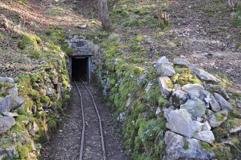
Extensive surface remains — shafts, hillocks, coes and buddles — survive across the wooded and open hillside, with the old Jaggers Road providing access. Several adits remain enterable and are regularly visited: Spinney Level, one of the valley's better-preserved workings, still floods seasonally at its entrance, and a 2022 exploration report describes surviving stone herring-bone roof supports and original wooden rails inside; the Goodluck Mine, driven in 1830, is maintained by a dedicated preservation group and still shows its adit and tramway.
Numerous shaft mounds, hillocks, coes and stone-lined buddles; several enterable adits including Spinney Level and Goodluck Mine.
Related mines
- Haslowfield Mine — Haslowfield is one of the lead levels and soughs of the Via Gellia, treated as a single group by the county record; it is named on the Via Gellia record.
Nearby mines
- Good Luck Mine — 0.1 miles (0.1 km) NW
- Slaley Sough — 0.4 miles (0.6 km) NE
- Bondog Hole Mine — 0.4 miles (0.7 km) SW
- Bonsall Leys Mines — 0.6 miles (1.0 km) N
- Hopton Wood Quarries and Middleton Mine — 0.7 miles (1.1 km) SE
Straight-line distance, within 9 miles (15 km). Show on the map.
Recorded claims
Individual factual claims, each attached to the source(s) that support it below. Where sources disagree, both are kept.
- A 1973 Peak District Mines Historical Society survey of just one enclosure east of Hoptonwood Quarries recorded 114 shafts, 37 of them already collapsed, along named veins including Thumper Sitch, Merry Tom, Doghole and several others. 1
- Thumper Sitch, one of the district's named veins, was already being worked by 1754 under 'Isaac Spencer, alias Thumper'; the wider field was well established by 1750. 1
- By his death in 1886, Edward Miller Wass held the majority interest across most of these mines as well as the nearby Lea smelting works; the collapse in lead prices after 1878 had already brought production to a standstill within five years, and the sale of his mining interests is thought to mark the effective end of regular working. 1
- The Merry Tom workings reached at least 300 feet via a series of linked winzes roughly 50 feet apart, descending from adit levels driven into the scarp face. 1
- Spinney Level, also known as Anglo-Saxon Mine or Haslowfield Mine, retains stone herring-bone roof supports and original wooden rails, though its entrance floods seasonally; the Goodluck Mine, driven in 1830, is maintained by a dedicated preservation group. 2,3
Photographs & further reading
A 2022 exploration report on Spinney Level, one of the valley's better-preserved adits, describing its stone herring-bone roof supports, wooden rails and seasonal flooding.
View sourceThe Peak District Mines Historical Society's own account of an underground trip into the Goodluck Mine, driven in 1830 and still maintained by a dedicated preservation group.
View sourceSources
- (primary) The Mines East of Hoptonwood Quarries, Via Gellia (Flindall & Hayes, 1973) — Peak District Mines Historical Society
- (observational) Spinney Level, Via Gellia, Matlock, Derbyshire, August 2022 — Derelict Places (urban exploration forum)
- (secondary) Goodluck Mine, Via Gellia — Derbyshire underground mine trip — Peak District Mines Historical Society
Record created: 2 September 2026 · Last researched: 3 September 2026