 MineArchive
Bonsall Leys Mines
| Also known as | Whitelow Mines |
|---|---|
| Location | Bonsall, near Matlock, Derbyshire — 53.1136, -1.6048 (exact) |
| Commodities | Lead, Barite, Fluorspar |
| Type | Metal |
| Worked | 1540s–19th century |
| Maximum depth | Shallow workings throughout -- surface rakes and shafts around 1.5 metres in diameter rather than a deep mine; shafts were left open until the 1980s, when they were capped with concrete railway sleepers for public safety. |
Overview
A scheduled lead-mining landscape on Bonsall Moor near Matlock, worked from at least the 1540s and thought to be nationally unparalleled in the complexity of its small-scale, intensive post-medieval lead extraction, followed later by fluorspar recovery from the same ground.
History
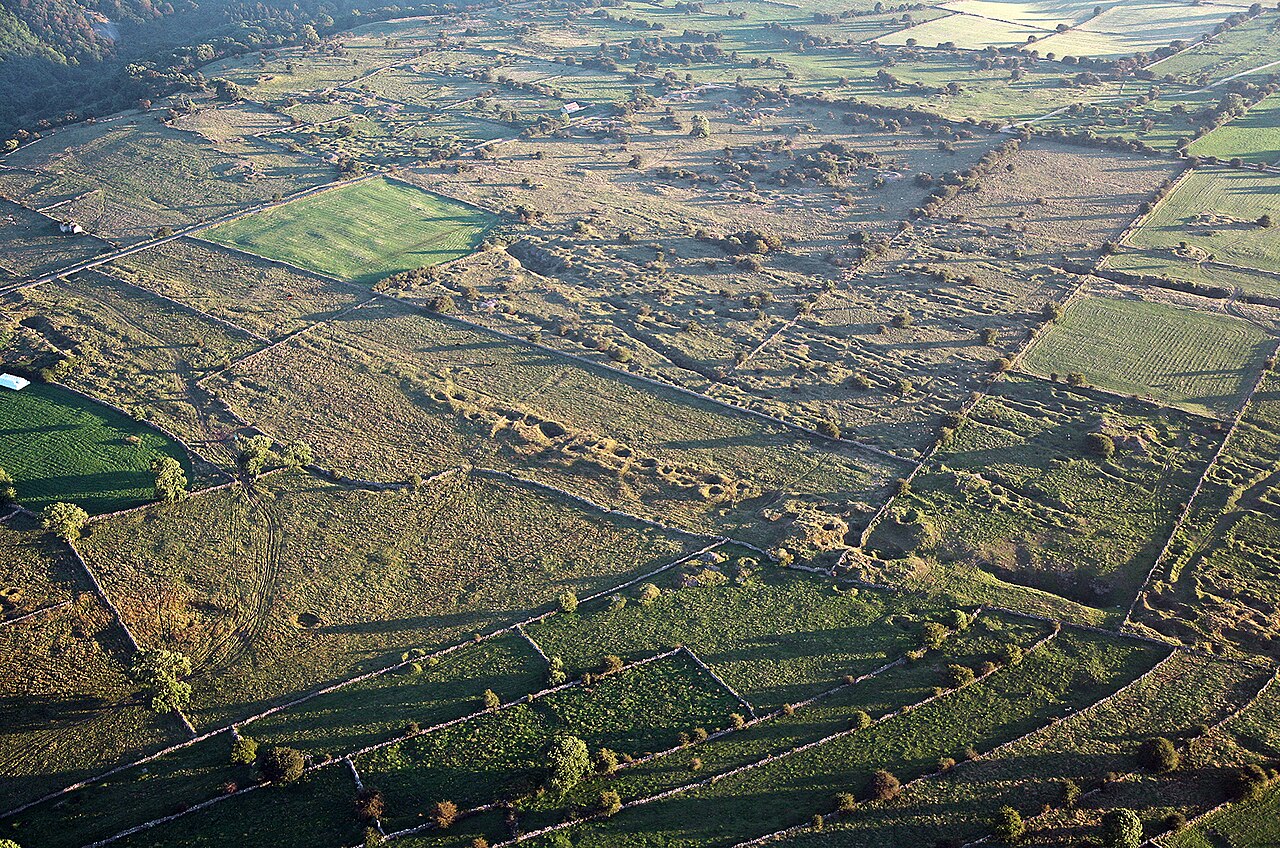
Lead mining at the site now known as Bonsall Leys is first documented in the 1540s under the name Whitelow mines, though the density and pattern of the surviving earthworks suggest the ground had probably been reworked many times already as mining and smelting techniques improved -- consistent with the wider Derbyshire lead field's roots in the Roman period. The main ore was galena, with fluorspar and baryte recovered as associated minerals; the site was worked by two methods, following veins along the surface in long rakes and sinking shallow shafts, each around 1.5 metres across and stone-lined, to reach and locate ore closer to the surface. Working continued through the 19th century, by which point the ground had been picked over so extensively that most of the spoil heaps were left devoid of any further recoverable mineral. A later phase of activity recovered fluorspar rather than lead from the same ground, evidenced today by two rusting cranes surviving among the earthworks. The shafts themselves were left open until the 1980s, when they were capped with concrete railway sleepers to protect the public, and the site was subsequently scheduled as a nationally important monument.
Geology
Lead of the Derbyshire orefield on Bonsall Moor. The ore was galena, with fluorspar and baryte recovered alongside it, and the veins were followed both along the surface in long rakes and by shallow stone-lined shafts about 1.5 metres across.
Workings
At least ten parallel rakes -- long, narrow surface excavations following the lead veins -- together with a scatter of shallow, stone-lined shafts around 1.5 metres in diameter and their associated spoil heaps, worked from the surface rather than through any single deep shaft.
Closure
No single closure date is recorded for lead working; the site continued in afteruse for fluorspar recovery once the lead was exhausted.
What remains
Now a scheduled monument crossed by the Limestone Way footpath, popular with walkers; the shafts, capped with concrete railway sleepers since the 1980s, and the ten parallel rakes remain clearly identifiable across mostly overgrown moorland.
Ten parallel lead rakes, numerous shallow capped shafts with spoil heaps, ruined structures and earthworks, and two rusting cranes surviving from the later fluorspar-recovery phase.
Nearby mines
- Slaley Sough — 0.5 miles (0.8 km) SE
- Good Luck Mine — 0.6 miles (0.9 km) S
- Via Gellia Lead Mines — 0.6 miles (1.0 km) S
- Bondog Hole Mine — 0.9 miles (1.5 km) S
- Haslowfield Mine — 0.9 miles (1.5 km) E
Straight-line distance, within 9 miles (15 km). Show on the map.
Culture
- T'Owd Man of Bonsall (Folklore)
The carving is a relief of a lead miner rescued from Bonsall parish church in the 1870s, and Bonsall Leys is the lead ground of that parish - a scheduled landscape on Bonsall Moor worked from at least the 1540s. The link is parish-level and no source ties the carving to a particular working; it is the image the Bonsall lead field kept of itself.
Recorded claims
Individual factual claims, each attached to the source(s) that support it below. Where sources disagree, both are kept.
- The site is a Historic England Scheduled Monument (list entry 1017755); its shallow pits, opencuts and hillocks of spoil and upcast are considered typical of lead working from extremely shallow ore bodies, and the site's complexity is thought to be unparalleled both within the Derbyshire orefield and nationally. 1
- The site was worked by two methods: rakes, lengthy surface excavations following the lead veins, and shallow, stone-lined shafts around 1.5 metres in diameter with associated spoil heaps, left open until the 1980s when they were capped with concrete railway sleepers. 2
- Two rusting cranes surviving among the earthworks are evidence of a later phase of fluorspar recovery from the site, after lead working had ended. 2
Photographs & further reading
A 2021 observational site visit report with photographs of the surviving rakes, shafts and fluorspar-era cranes.
View sourceSources
- (primary) Bonsall Leys Mines, Derbyshire — Gazetteer of British Place Names / Historic England Scheduled Monument record
- (secondary) Mines and minerals in Derbyshire (UK): Bonsall Leys Lead Mines — Mines and Minerals in Derbyshire (site survey blog)
Record created: 30 August 2026 · Last researched: 30 August 2026