 MineArchive
Temple Mine
| Also known as | Temple Lead Mine |
|---|---|
| Location | Rheidol gorge north of Parson's Bridge, Ysbyty Cynfyn, near Devil's Bridge, Ceredigion — 52.3968, -3.8402 (exact) |
| Commodities | Lead, Zinc |
| Type | Metal |
| Worked | 1876–1883 (suspended) |
| Maximum depth | 20 fathoms below the deep adit (about 37 m) |
| Operators | Temple Lead Mining Company (1876–1883) — Formed 1876 under Charles Thomas, ceased within a year, revived 1877; appears to have gone into liquidation in 1883. Cardigan United Mines Ltd (1886–1888) — Held with Llwynteifi and Bwlchgwyn; sank Rawcliff's Shaft to 15 fathoms. Aberystwyth Silver Lead Mines Ltd (1909–1912) — Two to four men underground in 1909-10; idle from 1911. |
Temple Mine was a small lead mine cut into the west bank of the Rheidol gorge just north of Parson's Bridge, near Ysbyty Cynfyn. A company formed in 1876 fitted it out with three waterwheels, a compressor and an inclined tramway up the side of the gorge, only to find the ore shoot poorer than hoped, and the mine was suspended in 1883. The 40-foot wheelpit beside the deep adit still stands.
Location
Recorded location. The large pin is this mine; the small round markers are the nearest mines on record. Click one for its page. View on full map
History
Temple began as part of the old Llwynteifi sett. When the Llwynteifi land was divided between three brothers of the Davies family, one share was sold to the Richards family of the Penglais estate, and that share became a separate sett. It took its name from a small stone circle close by, long held locally to be a Druid temple. By 1874 a new lode, called Pryse's, had been found some 40 fathoms south of the main lode, and it was on this that the mine was opened.
The Temple Lead Mining Company was formed in 1876 under Charles Thomas and lasted less than a year. Revived in 1877, it brought in John Croucher, formerly of Tynyfron, to put up the plant. A 30-foot wheel driving a Blake stone breaker and 24-inch crushing rolls came first, in June, followed that autumn by a dressing mill with a jig, four buddles and a dolly tub worked by a 14-foot wheel. The main 40-foot wheel started work in February 1880. Through flat rods and wire rope it pumped the shaft in the deep adit, drove a compressor for rock drills and worked the hoists and an inclined plane up the side of the gorge towards the road from Ystumtuen. Whatever else Temple was short of, it was not machinery.
The men numbered 42 in 1878 and 45 in 1879. In 1881 the shaft reached 20 fathoms below the deep adit, where the ore shoot proved poorer than expected, and sinking stopped. That year 100 tons of galena and 22 tons of blende were sold. Croucher left, four men remained in 1882, and in 1883 the company appears to have gone into liquidation.
Cardigan United Mines Ltd took Temple up with Llwynteifi and Bwlchgwyn from 1886 to 1888, with Absalom Francis as agent, and sank Rawcliff's Shaft to 15 fathoms; 17 men worked in 1886 and 1887, and the mine was suspended in 1889. The Lerry Mining Company proposed a restart in 1907. Booth, Brooks and Richards had six men there in 1908, and Aberystwyth Silver Lead Mines Ltd held it from 1909 to 1912 with two to four men underground before it fell idle. The official returns credit Temple with only 3 tons of lead ore and 20 tons of blende; Simon Hughes, who surveyed the mine in 1971, thought much of its output had been entered under neighbouring mines.
Geology
The mine worked a small lode about 75 m south-east of the much larger Castell lode, of which it is probably a branch. It strikes north-east and dips steeply south-east. The best ore lay in a steep shoot some 32 m long and 60 to 70 m high, in the core of an anticline which the lode crosses obliquely, in rocks of early Silurian age at the base of the Frongoch formation. The lode dies out quickly on either side.
Geological setting: Veins and Lodes (well documented example)
Workings
Three adits were driven west from the gorge. The top and middle adits were driven in 1877 as drifts on Pryse's lode, and the middle adit, at the level of the surface tramway, became the main haulage road, running on timber over the open stope. A cross-cut driven north from it in 1880 met a second, wider lode, which was followed west for a short distance and given up. The deep adit, beside the 40-foot wheelpit, holds a 20-fathom shaft sunk in its floor and the remains of the pumping gear: flat rods hung from the roof and a large timber angle bob over the shaft, with the rising main still in place. Whether the middle adit ever met the Bwlchgwyn workings under the hill has long been argued; a mine captain's survey of 1917 shows that it did not then give a way through.
Closure
The company appears to have gone into liquidation in 1883 and the mine was suspended. Nothing much came of the later attempts: Cardigan United Mines from 1886 until the mine was suspended again in 1889, and a few men between 1908 and 1910, after which it stood idle.
What remains
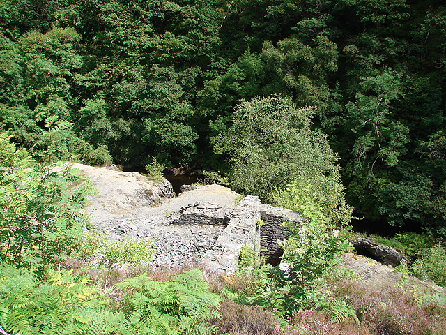
The mine stands on two rock-cut terraces above the river. The 40-foot wheelpit, with its winder pit and compressor bed, was surveyed by the Welsh Mines Preservation Trust in 2007 because of concern for the stability of its south-east corner; the site then belonged to the Countryside Council for Wales. A 2019 report from underground shows the deep adit open, with the angle bob, flat rods and rising main still there and the false floors of the upper adits fallen into the stope.
On the northern terrace, the 40-foot wheelpit beside the mouth of the deep adit, with the foundations of the winder. On the southern, the dressing floors: a 30-foot wheelpit of 1878 built of sandstone flags with a brick-lined arch, the walls of the crushing mill, two ore bins, a rock cutting for the 14-foot wheel and the base of a round buddle. The two are joined by the bed of a tramway. The course of the leat that fed the wheels, the trace of the incline up the valley side and a stone building that may have been the smithy also survive.
Related mines
- Bwlchgwyn Mine — Cardigan United Mines Ltd took up Temple together with Bwlchgwyn and Llwynteifi in 1886-88, and Temple's middle adit was driven towards the Bwlchgwyn workings.
- Llwynteifi Mine — Temple Mine was formed from the Pryse's lode part of the old Llwynteifi sett, and Cardigan United Mines worked the two together in 1886-88.
Nearby mines
- Llwynteifi Mine — 0.5 miles (0.9 km) SW
- Bwlchgwyn Mine — 0.7 miles (1.1 km) W
- Penrhiw Mine — 0.8 miles (1.3 km) SW
- Ystumtuen Mine — 1.0 miles (1.6 km) W
- Clara Mine — 1.1 miles (1.8 km) NW
Straight-line distance, within 9 miles (15 km). Show on the map.
Further reading
The Welsh Mines Preservation Trust's survey of the wheelpits, dressing floors and adits, with plans and a geological report.
View sourceA year-by-year chronology of the mine from 1876 to 1913 and Simon Hughes's short history.
View sourceA short site record of the mine and what remains on the surface.
View sourcePhotographs from underground showing the angle bob, flat rods and rising main in the deep adit.
View sourceSources
- (primary) Temple Lead Mine (NPRN 33901) — Coflein, Royal Commission on the Ancient and Historical Monuments of Wales
- (secondary) Temple Lead Mine, by Tim Wellburn and Martin Dixon (2013) — Subterranea Britannica
- (secondary) Temple Mine Historical Survey, edited by Graham Levins, with a brief history by Simon Hughes (Welsh Mines Preservation Trust, 2007) — Welsh Mines Preservation Trust, held by Coflein
- (secondary) Temple Mine Survey (2007), edited by Graham Levins: site survey by Nigel Chapman and geology by David James — Welsh Mines Preservation Trust, held by Coflein
- (primary) Lead and Zinc: The Mining District of North Cardiganshire and West Montgomeryshire (Special Reports on the Mineral Resources of Great Britain, vol. XX), O. T. Jones, 1922 — Memoirs of the Geological Survey
- (observational) Report - Temple Lead Mine, Ysbyty Cynfyn, Mid Wales - February 2019 — 28DaysLater
- (primary) Mine plan: Temple Mine, SN77NW 12 (KP16972) — British Geological Survey
Record created: 18 November 2026 · Last researched: 18 November 2026