 MineArchive
Siston Hill Colliery
| Also known as | Siston Common Colliery, Syston Hill Colliery |
|---|---|
| Location | Siston Hill, Siston, east of Bristol, South Gloucestershire — 51.4631, -2.4784 (exact) |
| Commodity | Coal |
| Type | Coal |
| Worked | c.1790–1876 (abandonment plan) |
| Maximum depth | 570 ft (about 174 m) |
| Operators | Mrs Peterson (1804–1804), Toghill and Company (1831–?), S. H. Hadley (1880–1880) |
Overview
A colliery on Siston Hill, east of Bristol, opened about 1790 in faulted Coal Measures south of the Kingswood Anticline. Owned by Mrs Peterson in 1804, Toghill and Company by 1831 and S. H. Hadley in 1880, it was offered for sale with four shafts in 1889 and never reopened.
History
Siston Hill Colliery, also recorded as Siston Common or Syston Hill Colliery, lay in the Bristol coalfield south of the Kingswood Anticline. The British Geological Survey dates its opening to around 1790; a Wikipedia account puts the sinking in the late 1790s or early nineteenth century. An accident report of 1804 names the owner as a Mrs Peterson, and by 1831 the pit belonged to Toghill and Company. The 1880 List of Mines gives the owner as S. H. Hadley.
The ground was complex and faulted, and the British Geological Survey records the colliery closed by 1889. An abandonment plan of the Siston Hill Nos 1 and 2 pits is dated 1876. In 1889 the colliery was put up for sale. The prospectus described four shafts, two of them sunk to 570 feet; a winding shaft 9 feet across, walled throughout and fitted with two cages; a Boulton and Watt winding engine with a 4 ft 6 in stroke and a 12-foot drum, able to raise 700 to 800 tons of coal a day; and a pumping engine with two 19-inch cylinders, still in working order. On the surface a bank stood high enough for double screens, with a tunnel at its foot so that timber and other materials could go down the pit without first being hauled to the top, and a circular chimney 100 feet high stood over the works. The sale failed and the colliery never reopened.
Geology
Coal Measures of the Bristol coalfield on the south side of the Kingswood Anticline, in complex, faulted ground.
Workings
Four shafts in 1889, two of them 570 feet deep; a walled winding shaft 9 feet in diameter with two cages; a Boulton and Watt winding engine and a pumping engine with two 19-inch cylinders; a screening bank with a supply tunnel at its foot; a chimney 100 feet high. A plan covers the Nos 1 and 2 pits.
Closure
Offered for sale in 1889 after working faulted ground; the sale failed and the colliery never reopened. An abandonment plan of Nos 1 and 2 pits is dated 1876.
What remains
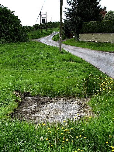
A capped shaft survives, its cap inscribed "NCB 1.8.50".
A capped shaft.
Redevelopment
Unknown.
Nearby mines
- Wick Ochre Mines — 1.5 miles (2.3 km) E
- Shortwood Colliery — 1.9 miles (3.1 km) NE
- Brandy Bottom Colliery — 2.2 miles (3.5 km) N, Gloucestershire
- Speedwell Colliery — 2.3 miles (3.6 km) W, Bristol
- Hanham Colliery — 2.3 miles (3.7 km) SW, Bristol
Straight-line distance, within 9 miles (15 km). Show on the map.
What's uncertain
Points where sources disagree or the record could not be settled; both accounts are kept. All open questions in the archive.
- Sunk in the late 1790s or early nineteenth century. (uncertain) 2
Recorded claims
Individual factual claims, each attached to the source(s) that support it below. Where sources disagree, both are kept.
- Opened around 1790. 1
- Sunk in the late 1790s or early nineteenth century. (uncertain) 2
- Owned by a Mrs Peterson in 1804, Toghill and Company by 1831, and S. H. Hadley in 1880. 2
- Had four shafts in 1889, two of them sunk to 570 feet, with a Boulton and Watt winding engine able to raise 700 to 800 tons a day. 2
- An abandonment plan of Siston Hill Nos 1 and 2 pits is dated 1876. 3
- Worked complex, faulted ground and closed by 1889; offered for sale that year and never reopened. 2,1
Sources
- (secondary) Geology of the Bath area: Applied geology: mineral resources — British Geological Survey (Earthwise)
- (secondary) Siston Hill Colliery — Wikipedia
- (primary) BGS mine plan: Siston Hill Nos 1 and 2 (abandoned 1876) — British Geological Survey / Mining Remediation Authority
Record created: 17 October 2026 · Last researched: 17 October 2026