 MineArchive
Brandy Bottom Colliery
| Also known as | Parkfield Colliery South, Parkfield South |
|---|---|
| Location | Emersons Green, near Pucklechurch, Gloucestershire — 51.4920, -2.4598 (approximate) |
| Commodity | Coal |
| Type | Coal |
| Worked | Early 1800s–1936 |
| Maximum depth | 225 yards (about 206 m), from Handel Cossham's notebook. |
| Operators | Wethered, Cossham and Wethered (1850–?), Bristol United Collieries (1890–1914), East Bristol Collieries Ltd (1914–1936) |
Overview
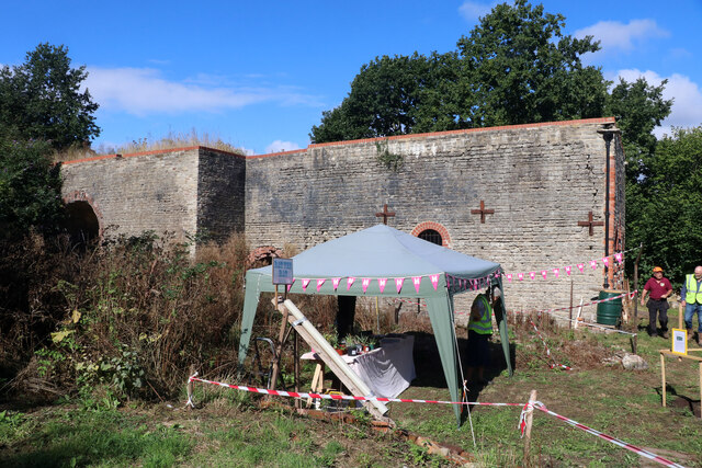
A steam-powered colliery on the Bristol coalfield east of the city, sunk in the early 1800s on the site of an 18th-century pit and leased in the 1850s to pump and ventilate the neighbouring Parkfield Colliery, under whose name it worked as Parkfield South. Its beam and horizontal engine houses, fan house and chimney survive together — a rare complete 19th-century colliery surface — and have been under conservation since 2007.
History
Coal had been dug in Kingswood, east of Bristol, from at least the reign of Edward I, and by 1679 the coal pits there were being recommended to visitors as a sight worth seeing. Brandy Bottom was sunk in the early 1800s on the site of an earlier 18th-century colliery and was owned by Lord Radnor; the name is first noted in 1856, and the first pits on the site are dated to about 1837. In the 1850s it was leased to Wethered, Cossham and Wethered to help the adjacent Parkfield Colliery, a kilometre to the north-east, with pumping and ventilation, and it became known as Parkfield Colliery South, 225 yards deep according to Handel Cossham's notebook. Cossham was the leading colliery owner of the Bristol district in the later 19th century: until his death in 1889 he controlled the Kingswood and Parkfield collieries, whose property in 1891 ran to about 3,000 acres of mineral freehold with a daily output of 700 to 1,000 tons and some 1,500 people employed. A new pit was sunk at Brandy Bottom in 1871. Coal drawing here had ceased before the First World War and the pit was kept on to ventilate its neighbour; all operations stopped in 1936, when flooding, pumping costs and dwindling reserves closed Parkfield too. The buildings survived because the site declined slowly as a satellite operation and was then taken over by the nearby Shortwood brickworks.
Geology
The colliery worked the Bristol coalfield at the foot of a west-facing slope in ground full of springs and wells. At Parkfield, its parent pit, the shaft was 840 feet deep but only the upper series of veins — the Hard, the Top, the Hollybush and the Great — were worked, and the coal was good enough for gas making and house coal.
Workings
The surviving surface buildings are the point of the place: a single-storey twin-cylinder horizontal steam winding engine house, a steam-powered fan house, a Cornish beam engine house and a stone and brick boiler chimney, with the buried bases of engines and boiler settings beneath them. All the main buildings appear on the plan that accompanied the sale catalogue of 1900. At the north end of the site, by the disused railway that carried the coal away, is a small unroofed brick weighbridge building about 3 m by 2 m, and beside it the two halves of a spoked iron headgear wheel about 6 m across — brought in from a South Wales colliery, but of the type used here and scheduled with the site. A spoil tip marks the southern limit of the ground.
Closure
Coal drawing stopped before the First World War, after which the pit ventilated Parkfield; all operations ceased in 1936, the year flooding and pumping costs closed Parkfield itself on 15 August. The site has been derelict since.
What remains
The colliery is a scheduled monument and one of the most complete 19th-century colliery surfaces in the country, its buildings surviving minus the removable fittings. The Avon Industrial Buildings Trust has worked since 2007 with Ibstock Brick, the landowner, and Historic England to halt the decay: a first stage of site, topographical and rectified-photographic survey was finished by the end of 2008, and structural survey, archaeological work and building conservation have followed, each stage approved in advance by Historic England.
The horizontal winding engine house, the Cornish beam engine house, the fan house, the boiler chimney, the weighbridge, a South Wales headgear wheel in two halves, the spoil tip and the cutting of the colliery railway.
Redevelopment
None. The site passed to the Avon Industrial Buildings Trust by way of South Gloucestershire Council in about 2005 and is being conserved as a monument.
Nearby mines
- Shortwood Colliery — 0.5 km S, South Gloucestershire
- Parkfield Colliery — 1.1 km S, Bristol
- Ram Hill Colliery — 3.2 km NE
- Serridge Pit — 3.6 km N
- Wick Ochre Mines — 3.7 km S, South Gloucestershire
Straight-line distance, within 15 km. Show on the map.
Recorded claims
Individual factual claims, each attached to the source(s) that support it below. Where sources disagree, both are kept.
- Brandy Bottom was sunk in the early 1800s on the site of an earlier 18th-century colliery and was owned by Lord Radnor; in the 1850s it was leased to Wethered, Cossham and Wethered to assist Parkfield Colliery with pumping and ventilation. 1
- The shaft was 225 yards deep according to Handel Cossham's notebook, and the colliery then became known as Parkfield Colliery South. 1
- Cossham's company held about 3,000 acres of mineral freehold in 1891, with a daily output of 700 to 1,000 tons of steam and house coal and some 1,500 people employed above and below ground. 1
- The standing buildings include a twin-cylinder horizontal winding engine house, a steam-powered fan house, a Cornish beam engine house and a boiler chimney, all of which appear on the plan accompanying the 1900 sale catalogue. 1,2
- Coal drawing at Brandy Bottom ceased before the First World War and the pit was then used to ventilate Parkfield; all operations ceased in 1936, when Parkfield itself closed on 15 August. 3,2
Photographs & further reading
The society's account of why the buildings survived and of the Avon Industrial Buildings Trust conservation project begun in 2007, with links to its progress pages.
View sourceThe neighbouring colliery that Brandy Bottom served, with its sinking in 1851 under Handel Cossham, its plant as surveyed in 1890 and its closure in 1936.
View sourceSources
- (primary) Brandy Bottom Colliery, part of Parkfield Colliery, Pucklechurch (Historic England list entry 1019400) — Historic England
- (secondary) Brandy Bottom Colliery — Bristol Industrial Archaeological Society
- (secondary) Parkfield Colliery — Wikipedia
- (primary) Abandoned mine plan catalogue entry: BRANDY BOTTOM — British Geological Survey
Record created: 22 September 2026 · Last researched: 22 September 2026