 MineArchive
Rigg Head Quarry
| Also known as | Rigghead Quarries, Rigg Head Quarries |
|---|---|
| Location | Rigg Head, above Seatoller, Borrowdale, Cumbria — 54.5269, -3.1789 (approximate) |
| Commodity | Slate |
| Type | Slate |
| Worked | from Working by 1930 |
| Maximum depth | Unknown. |
| Operators | Smith and Plaskett (1930–?) |
Overview
Rigg Head appears in the 1930 List of Mines with a workforce of two — one man underground and one at the surface — working slate for Smith and Plaskett of Stonethwaite. The quarries lie high on the fellside between Borrowdale and the col below Dale Head, and what is left of them now is a steep industrial graveyard of shafts, adits, spoil and ruined buildings that walkers climb through on the way to Dalehead Tarn.
History
The 1930 List of Mines under the Metalliferous Mines Act enters Rigg Head in Borrowdale, owned by Smith and Plaskett of Stonethwaite, with one man underground and one at the surface, working slate. That is the whole of the documented working life found for this quarry: a two-man operation at the end of the industry's long contraction.
It was one of a scatter of Borrowdale workings — Honister, Yew Crag, Dubs, Rigghead, Quay Foot and smaller sites still — which between them gave the valley a livelihood for more than 350 years. The work was hard everywhere in the Lakeland slate trade and harder at a place like this. Blasted blocks were bored and blasted again until they were small enough to move, then reduced with sledgehammer and wedge and carried to the riving shed, where the river split them into sheets and the dresser shaped each slate with a heavy knife. The quarries themselves were, as the industry's own historians put it, primitive in the extreme, with no provision for the quarrymen's comfort and very little for their safety — and at Rigg Head the day began with a steep climb up the fellside before any of it started.
Geology
Borrowdale's slate is not a true slate in the geologist's sense but the cleaved volcanic tuffs of the Borrowdale Volcanic Group — ash laid down in the Ordovician and later compressed until it split cleanly along a cleavage that cuts across the original bedding. The same rocks give the green slates worked at Honister and Elterwater and the silver-greys of Coniston Old Man. Workable stone was taken first from surface outcrops and open quarries, and later followed underground by levels driven in along the vein — which is what the 1930 return's single man underground implies here.
Geological setting: Sedimentary Beds and Seams (historical documentary reference)
Workings
Open workings and underground levels together: the ground carries shafts and adits among the spoil. The 1930 return's split of one man underground and one at the surface is the only figure found for the workforce, and nothing on record gives the extent of the levels.
Closure
The closure date is not known. The quarry was working, just, in 1930; the Lakeland slate industry contracted sharply through the 20th century and is now a fraction of its size at the turn of the century, surviving at Kirkby, Broughton Moor, Elterwater, Kirkstone and Honister rather than at small fellside workings like this one.
What remains
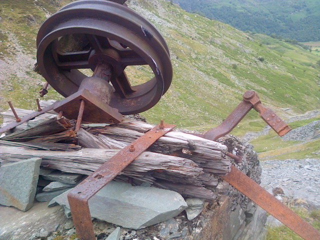
Derelict and open to the fell. A 2015 walker's account describes it as an industrial graveyard — shafts and adits, piles of quarry spoil and ruinous buildings on ground steep enough to make the going slow — reached by a green path up a grassy tongue near Tongue Gill and left by a stile onto the peat moors towards Dalehead Tarn. Disused quarry equipment still lies among the workings.
Ruined buildings, spoil heaps, shafts and adit mouths spread across the steep hillside, with abandoned equipment still on the ground and a climbing hut standing among the workings. Part of the footpath below is a staircase of slate.
Related mines
- Gate Crag Quarry — Both were returned in the same 1930 Cumberland list as small Borrowdale slate workings — Gate Crag with eight people and mining already suspended, Rigg Head with two — and both belong to the scatter of family-scale quarries the valley's own history names together with Honister, Yew Crag, Dubs and Quay Foot.
Nearby mines
- Long Work Copper Mine — 0.9 miles (1.4 km) NW
- Yew Craggs Quarry — 0.9 miles (1.5 km) SW
- St Thomas' Work Copper Mine — 1.0 miles (1.6 km) NW
- Dale Head Copper Mine — 1.0 miles (1.7 km) W
- Castlenook Mine — 1.2 miles (1.9 km) NW
Straight-line distance, within 9 miles (15 km). Show on the map.
Recorded claims
Individual factual claims, each attached to the source(s) that support it below. Where sources disagree, both are kept.
- The 1930 List of Mines records Rigg Head in Borrowdale, owned by Smith and Plaskett of Stonethwaite, with one man underground and one at the surface, working slate. 1
- Borrowdale slate and stone was extracted at several places in the valley including Honister, Yew Crag, Dubs, Rigghead and Quay Foot, which between them provided a livelihood in Borrowdale for over 350 years. 2
- Blasted blocks were bored and blasted again until manageable, then reduced with sledgehammers and wedges and carried to the riving shed, where the river split the stone into thin sheets and the dresser shaped them into slates with a heavy knife; the quarries had no provision for the quarrymen's comfort and very little for their safety. 3
- A 2015 account describes the quarries as an industrial graveyard of shafts, adits, quarry spoil and ruinous buildings on ground steep enough to make walking slow — the climb the quarrymen made at the start of a fourteen-hour shift. 4
Photographs & further reading
A 2015 walk from Seatoller up through the quarries to Dalehead Tarn and Dale Head, which is the only description found of the site as it now stands: shafts and adits among the spoil, ruinous buildings, and the steep grassy tongue that is the way in.
View sourceSources
- (primary) 1930 List of Mines under the Metalliferous Mines Act: Cumberland — Durham Mining Museum
- (secondary) Mining and Quarrying in Borrowdale — The Borrowdale Story
- (secondary) Slate — the Cumbrian slate industry, its geology, working and decline — Cumbria Industrial History Society
- (observational) Dale Head via Rigghead Quarries — a walk through the workings, 2015 — One Foot in the Lakes
Record created: 5 September 2026 · Last researched: 6 September 2026