 MineArchive
Dale Head Copper Mine
| Also known as | Dalehead Mine |
|---|---|
| Location | Dale Head Crags, head of the Newlands valley, near Little Town, Cumbria — 54.5306, -3.2037 (approximate) |
| Commodity | Copper |
| Type | Metal |
| Worked | c. 1700–No reliable closure date has yet been located. |
| Maximum depth | Unknown. |
| Operators | Thomas Robinson (1700–1700) |
Overview
A small copper mine high on the Newlands face of Dale Head, at the head of the Newlands valley, thought to have been worked about 1700 by Thomas Robinson and with Cornish mining engineers employed around 1775. No record of working survives from the 19th century on, and its levels, spoil and hand-dressing floor with a small stone building are protected as a scheduled monument, a rare 18th-century copper dressing site left untouched since abandonment.
History
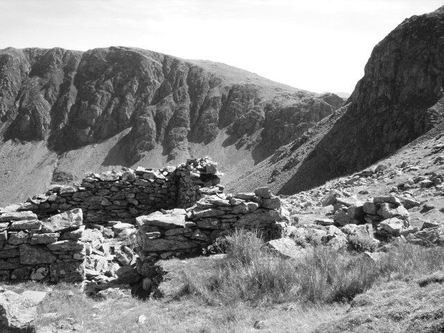
Copper was mined in the Newlands valley in the 16th century, when the Mines Royal Company, leaders in European mining technology through the 16th and 17th centuries, worked many mines around Keswick, but whether Dale Head was one of them is not known. The mine itself is thought to have been worked in about 1700 by one Thomas Robinson, and Cornish mining engineers are thought to have been employed here around 1775; the level thought to have been Robinson's, and later the Cornish miners', opens at the head of a waterfall in precipitous ground and is hand-drilled, with an internal railway of iron strips laid on wooden rails that suggests mid-18th-century working. There are no records of any mining at Dale Head from the 19th century onwards, and the site was left much as its last workers found it. On gentler ground below Dale Head Crags the ore was broken and sorted by hand on a sheltered, paved dressing floor, beside a two-roomed stone building variously described as a smithy, a mine shop or a store; a stone mortar or anvil used for crushing the ore by hand lay among the stones of the floor's protecting wall until a local mining history society removed it in the 1990s. The levels were investigated in the 1980s, when the highest was dug out to reveal a tunnel about 160 yards long with old rails and a connection to a level above. The remains were scheduled in two parts on 25 June 2001: the upper mines with their spoil heap and dressing floor, and the dressing floors and buildings below.
Geology
Copper ore: the waste on the dressing floor is spotted with the copper ore malachite. The lode itself is not described.
Workings
Several levels driven below the northern crags of Dale Head, still visible on the fellside, with spoil below them and, on the gentler ground beneath the crags, a hand-dressing floor, the mine building, a prospecting trench and a prospecting pit. Historic England's entry for the upper part, 300 metres north-east of the summit, describes two mines: an adit or level now blocked by scree, with a spoil heap below it carrying a small dressing floor, and a little lower, at the head of a waterfall, an open hand-drilled level with an internal railway of iron strips on wooden rails. A 2022 visitor recorded a level about 200 yards long with a wooden tramway whose rails were capped with iron strips, which matches that description. Lower down the valley floor lie the older open workings of Long Work and St Thomas' Work, drained by a short adit near Newlands Beck, which are separate sites.
Closure
No closure date is recorded. The mine is thought to have been worked around 1700 and again around 1775, when Cornish engineers were employed, and there are no records of any mining here from the 19th century onwards; why work stopped is not known.
What remains
The remains are a scheduled monument, and Historic England describes the dressing floors and buildings as surviving well, a rare example of an 18th-century copper ore dressing site untouched since abandonment, and judges the upper mines, spoil heap and dressing floor to survive reasonably well, offering an exceptionally good opportunity to study 18th-century copper mining and the non-local technology the Cornish engineers brought. The two-roomed building stands up to 1.5 metres high with its internal fireplace uprights in place, and the dressing waste lies in low mounds spotted with malachite. In 2022 a visitor found the highest level blocked by scree, water pouring from the 200-yard level with a rockfall damming the stream inside, and the spoil and ruin still plain on the fellside.
A two-roomed stone building with a south annexe, a paved hand-dressing floor within a drystone shelter, low mounds of dressing waste, a small dressing floor on the spoil heap below the upper level, a prospecting trench and pit, spoil heaps and the mouths of several levels, the highest blocked by scree.
Redevelopment
None: the remains are protected as a scheduled monument.
Nearby mines
- Long Work Copper Mine — 0.7 km NE
- Castlenook Mine — 1.2 km NE
- Rigg Head Quarry — 1.7 km E
- Yew Craggs Quarry — 1.9 km SE
- Honister Slate Mine — 2.3 km S
Straight-line distance, within 15 km. Show on the map.
People
- Thomas Robinson · proprietor, 1700 — via the operator record
What's uncertain
Points where sources disagree or the record could not be settled; both accounts are kept. All open questions in the archive.
- The mine is thought to have been worked in about 1700 by one Thomas Robinson. (uncertain) 1
Recorded claims
Individual factual claims, each attached to the source(s) that support it below. Where sources disagree, both are kept.
- The mine is thought to have been worked in about 1700 by one Thomas Robinson. (uncertain) 1
- Cornish mining engineers are thought to have been employed at the mine around 1775, and there are no records of any mining at Dale Head from the 19th century onwards. 1
- A stone mortar or anvil for hand-crushing the ore, found in the wall of the sheltered dressing floor, was removed by a local mining history society in the 1990s. 1
- The dressing floors and associated buildings were scheduled on 25 June 2001 (list entry 1019942). 1
- When the highest level was dug out in the 1980s a tunnel about 160 yards long was found, with old rails and a connection to a higher level; in 2022 it was again blocked by scree. 2
- Several of the mine's levels below the northern crags of Dale Head are still visible. 2,3
- An open level at the head of a waterfall, considered to be the one worked by Robinson and later by the Cornish miners, is hand-drilled and contains an internal railway of iron strips laid on wooden rails, suggesting mid-18th-century working. 2,4
- The upper mines, spoil heap and ore dressing floor 300 m north-east of the summit were scheduled on 25 June 2001 as list entry 1019943. 4
Photographs & further reading
The description of the dressing floor, the mine building and the prospecting remains, with the mine's known history and the reasons for scheduling.
View sourceA photographic report on the Dale Head levels, the dressing area and the valley-floor workings below.
View sourceThe scheduling entry for the two upper mines, their spoil heap and dressing floor, including the hand-drilled level with its iron-and-wood railway.
View sourceSources
- (primary) Dale Head copper mine dressing floors and associated buildings 400m north of Dale Head (list entry 1019942) — Historic England scheduling text, reproduced by ancientmonuments.uk
- (observational) Mines 14 - Dale Head Copper (Cumbria, Mar, 2022) — 28DaysLater (urbanchemist)
- (secondary) Dale Head — Wikipedia
- (primary) Dale Head copper mine 300m north east of Dale Head (list entry 1019943) — Historic England, National Heritage List for England
- (primary) Brandelhow Barrow Dalehead Forcecrag Goldscope Plumbago Thornthwaite (BGS Mine Plans Catalogue) — British Geological Survey / The Coal Authority
Record created: 18 September 2026 · Last researched: 18 September 2026