 MineArchive
Porth Neigwl Lead Mine
| Also known as | Portnigel Lead Mine, Llanengan Lead Mine, Tan yr Allt Mine |
|---|---|
| Location | Tan yr Allt, just outside Llanengan, above Porth Neigwl, Llŷn, Gwynedd — 52.8114, -4.5317 (exact) |
| Commodity | Lead |
| Type | Metal |
| Worked | 17th century–by 1889 |
| Maximum depth | Unknown. |
Overview
A lead mine at Tan yr Allt, just outside Llanengan on the Llŷn peninsula, perhaps worked since the 17th century, reopened in the 1870s and closed by 1892, whose chimney of about 1878 still stands.
History
Porth Neigwl (Portnigel) lead mine lies at Tan yr Allt, just outside the village of Llanengan, above the bay of Porth Neigwl (Hell's Mouth) on the Llŷn peninsula. It was one of several mines working the lead and copper veins of the Penrhyn Du district, and may date from the 17th century or earlier. In July 1876 the agents of the Portnigel mine, with those of the neighbouring Tanybwlch, Assheton and Penrhyn mines, appealed to the Pwllheli assessment committee against their rates; showing from their books that output fell short of the figure assessed, they had the Portnigel royalty valuation cut from £240 to £170.
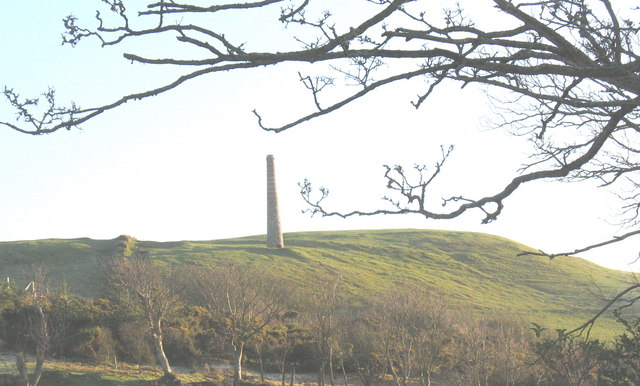
The mine was reopened in the 1870s with buildings at Tanrallt, and the tall chimney on the hillside to the south-east is believed to have been built about 1878. Covered flues in the field below run to it, but whether it ventilated the mine or served an engine or a smelter is not known. Accounts of the end differ: the mine is said to have closed with the other Llanengan mines in 1892, but it is already marked disused on the Ordnance Survey map of 1889.
Geology
Lead and copper veins of the Penrhyn Du district.
Workings
A shaft and other workings at Tan yr Allt, with covered flues running uphill to a free-standing chimney.
Closure
Marked disused on the Ordnance Survey map of 1889; another account has it closing with the other Llanengan mines in 1892.
What remains
The chimney stands on the hillside as a landmark; spoil tips, buildings and a shaft survive at Tan yr Allt below.
A tall circular chimney of rubble stone topped with red and yellow banded brick (listed Grade II), spoil tips, buildings and a shaft.
Redevelopment
Farmland.
Related mines
- Penrhyn Du Mines — Neighbouring mines on the same Llanengan lead and copper veins, closing together about 1892.
Nearby mines
- Penrhyn Du Mines — 1.8 miles (2.8 km) E
- Benallt Mine — 4.6 miles (7.4 km) W
Straight-line distance, within 9 miles (15 km). Show on the map.
What's uncertain
Points where sources disagree or the record could not be settled; both accounts are kept. All open questions in the archive.
- The Llanengan mine was reopened in the 1870s and closed with the other local mines in 1892. (disputed) 4
- The Porth Neigwl mine had already closed and was marked disused on the Ordnance Survey map of 1889. (disputed) 1
Recorded claims
Individual factual claims, each attached to the source(s) that support it below. Where sources disagree, both are kept.
- Porth Neigwl lead mine at Tan yr Allt was one of several in the Llanengan area and may date from the 17th century or earlier. 1,2
- In 1876 the Pwllheli assessment committee reduced the Portnigel lead mine's royalty valuation from £240 to £170 after its agents showed lower output. 3
- The mine's chimney, of rubble stone with a red and yellow brick top, is believed to have been built about 1878 and its purpose is uncertain. 4,2
- A chimney seen from the road to Porth Neigwl marks the former lead workings just outside Llanengan. 5,6
- The Llanengan mine was reopened in the 1870s and closed with the other local mines in 1892. (disputed) 4
- The Porth Neigwl mine had already closed and was marked disused on the Ordnance Survey map of 1889. (disputed) 1
- An abandonment plan of the Portnigel lead ore workings is held in the national mine plans collection. 7
Sources
- (secondary) Porth-Neigwl Lead Mine; Portnigel Lead Mine, Llanengan (NPRN 33792) — Coflein (RCAHMW)
- (secondary) Chimney, Portnigel; Porth-Neigwl Lead Mine, Llanengan (NPRN 409206) — Coflein (RCAHMW)
- (primary) The North Wales Chronicle, 29 July 1876: Pwllheli: assessment committee — The North Wales Chronicle (Welsh Newspapers Online, National Library of Wales)
- (secondary) Chimney of former Llanengan lead mine (Grade II) — British Listed Buildings (Cadw listing text)
- (secondary) Llanengan — Wikipedia
- (observational) The ventilation chimney of Tan 'rallt lead mine (Geograph 641509) — Geograph Britain and Ireland
- (primary) BGS mine plans: PORTNIGEL PARRY'S (lead ore) — British Geological Survey / Mining Remediation Authority
Record created: 20 October 2026 · Last researched: 20 October 2026