 MineArchive
Polbreen Mine
| Also known as | Polbreen, New Kitty, North Polbreen, New Polbreen |
|---|---|
| Location | St Agnes, Cornwall — 50.3085, -5.2075 (approximate) |
| Commodities | Tin, Copper |
| Type | Metal |
| Worked | By 1829–By 1891 |
| Maximum depth | Dorcas's Shaft went vertically to the Adit Level at 25 fathoms and then on the lode's underlie to the 52-fathom level; Vivian's Shaft in North Polbreen reached 50 fathoms below an adit at 40. |
Overview
A St Agnes tin and copper mine at the foot of St Agnes Beacon, later called New Kitty, worked chiefly on Dorcas's and Tregay's lodes. Its main shaft carries the name of a woman said to have thrown herself down it, and the Geological Survey records the lode under her name too.
History
Polbreen lies at the foot of St Agnes Beacon, just north of the St Agnes to Chapel Coombe road, in the killas country beneath the town itself. It belongs to the West Kitty group of mines, the westward continuation of the Wheal Kitty flat lodes, and was later called New Kitty. Unlike most of that group it worked mainly on two vertical lodes rather than the flat ones: Dorcas's Lode, which underlies ten degrees south, and Tregay's, nearly vertical, both coursing thirty degrees north of east. Recorded output for Polbreen and New Kitty together is 520 tons of black tin, in 1839 and from 1858 to 1887, with 250 tons of six per cent copper ore in 1829, 1836 and 1840 and a further six tons in 1873.
The workings were extensive but shallow and thinly productive. Dorcas's Shaft, also called Thorpe's, stood seventy yards south west of the Smith's Arms inn and went down vertically to the Adit Level at twenty-five fathoms, then followed the lode's underlie to the fifty-two. The Engine Shaft lay a hundred and sixty-eight yards west south west of it, and Shop Shaft seventy yards beyond that. Plans dated up to 1891 show the Adit Level running two hundred and ninety-five fathoms, but the stopes on Dorcas's Lode are patchy and only about a tenth of the blocked-out ground was ever removed; Tregay's Lode, worked from the Engine Shaft, gave up about sixty per cent of its ground. A northern section called North or New Polbreen was developed from Vivian's, or Stainsby's, Shaft down to fifty fathoms below adit on ground reputed to be of poor grade.
In Cornish tradition the mine was haunted. Robert Hunt, collecting in the 1860s, recorded that a woman named Dorcas had lived in one of the small cottages immediately adjoining the mine and had thrown herself down one of its deep shafts. Afterwards she was held to call miners by name and lure them from their work, so that a tributer who had made a poor month would be asked whether he had been chasing Dorcas. On one occasion only was she thought to have acted kindly: a miner called from his end by his own name repeated three times threw down his hammer to find out who wanted him, and a mass of rock fell where he had been standing. He said to his dying day that he owed his life to Dorcas. Hunt noted that the shaft still bore her name, and the Geological Survey's own account of the mine names both the shaft and the lode after her.
Geology
The country rock is killas. The chief lodes worked were Dorcas's and Tregay's, both coursing about thirty degrees north of east: Dorcas's underlies ten degrees south, while Tregay's stands nearly vertical, ten fathoms north of it at adit level. Polbreen is unusual in its group for working vertical lodes rather than the flat ones that made Wheal Kitty; the West Kitty flat lode passes south into Polbreen and is believed to crop out near Dorcas's Lode, but is barren in the upper levels. A major crosscourse trending fifteen degrees west of north crosses Dorcas's Lode fifty-five fathoms west of the shaft at adit level, with smaller ones further east, though the heave of the lode is small.
Geological setting: Veins and Lodes (well documented example)
Workings
Four shafts are recorded. Dorcas's, also called Thorpe's, stood seventy yards south west of the Smith's Arms inn, vertical to the Adit Level at twenty-five fathoms and then on the underlie to the fifty-two. Engine Shaft lay a hundred and sixty-eight yards west south west of Dorcas's, vertical to the thirty-two fathom level, and Shop Shaft seventy yards south west of that, vertical to the twenty-two. Vivian's, or Stainsby's, Shaft, a hundred and fifty yards north by west of Engine Shaft, served the North or New Polbreen section and went to fifty fathoms below adit. The Adit Level ran two hundred and ninety-five fathoms; the twenty-two and thirty-two fathom levels opened the lode over two hundred and thirty fathoms. Tregay's Lode was worked mainly from the Engine Shaft and stoped from surface to the twenty-four fathom level for fifty fathoms west of it.
Closure
The latest plans of the mine are dated 1891 and the recorded tin output ends in 1887. The mine's ground was later absorbed into the West Kitty group, under which name it continued to be worked, Polbreen having by then become New Kitty.
What remains
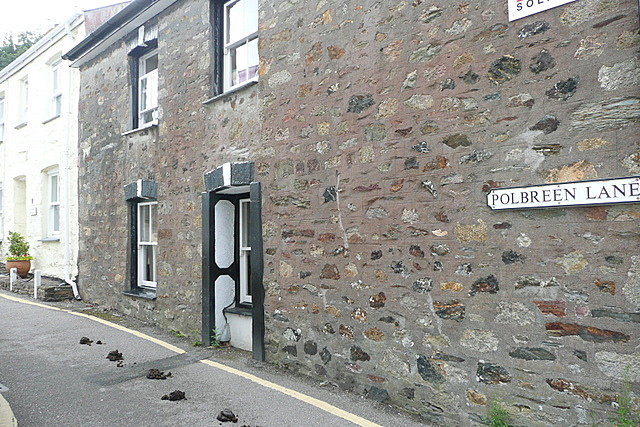
The mine lies under St Agnes itself and nothing of the workings is visible as such. Some of the former mining cottages survive in Polbreen Lane, the same row of small cottages adjoining the mine in which Dorcas was said to have lived.
Built over. The shafts stood among what are now the streets of St Agnes — Dorcas's within seventy yards of the Smith's Arms — and the former mining cottages of Polbreen Lane are the clearest surviving trace.
Redevelopment
The mine's ground is built over by the town of St Agnes, which grew across it.
Related mines
- Wheal Kitty — Polbreen is part of the West Kitty group, the westward continuation of the Wheal Kitty flat lodes, and was itself later renamed New Kitty; the West Kitty flat lode passes south into Polbreen and is believed to crop out near Dorcas's Lode.
Nearby mines
- Turnavore Mine — 0.8 km NE
- Polberro Mine — 0.9 km NW
- Trevaunance Mine — 0.9 km NE
- Wheal Friendly — 0.9 km N
- Wheal Kine — 0.9 km NE
Straight-line distance, within 15 km. Show on the map.
Recorded claims
Individual factual claims, each attached to the source(s) that support it below. Where sources disagree, both are kept.
- Polbreen, later called New Kitty, lies at SW 71711 50317 just north of the St Agnes to Chapel Coombe road, within the West Kitty group of mines beneath St Agnes town; the country rock is killas. 1
- The mine worked chiefly on Dorcas's and Tregay's lodes, both coursing thirty degrees north of east, the former underlying ten degrees south and the latter nearly vertical. 1
- Dorcas's Shaft, also called Thorpe's, stood seventy yards south west of the Smith's Arms inn, vertical to the Adit Level at twenty-five fathoms and on the underlie to the fifty-two fathom level. 1
- Engine Shaft lay 168 yards west south west of Dorcas's and reached the 32-fathom level, and Shop Shaft 70 yards south west of Engine Shaft reached the 22-fathom. 1
- Plans dated up to 1891 show the Adit Level running 295 fathoms and the 22 and 32 fathom levels opening the lode over 230 fathoms, but the stopes below adit are very patchy and only about ten per cent of the blocked-out ground was removed. 1
- Tregay's Lode, worked mainly from the Engine Shaft, was stoped from surface to the 24-fathom level for fifty fathoms west of the shaft, about sixty per cent of its blocked-out ground being removed. 1
- A section called North or New Polbreen was developed from Vivian's, or Stainsby's, Shaft, 150 yards north by west of the Engine Shaft, down to the 50-fathom level below an adit at 40 fathoms, on lode reputed to be of poor grade. 1
- Recorded output for Polbreen and New Kitty is 520 tons of black tin in 1839 and from 1858 to 1887, with 250 tons of six per cent copper ore in 1829, 1836 and 1840 and a further six tons of copper ore in 1873. 1
- Robert Hunt records that a woman called Dorcas lived in one of the small cottages immediately adjoining the mine and threw herself down one of its deep shafts, and that her presence afterwards remained in the mine. 2
- In the tradition Hunt collected, Dorcas called industrious miners by name and lured them from their tasks, to the point that a tributer who had made a poor month was asked whether he had been chasing Dorcas. 2
- Hunt gives one occasion on which Dorcas was thought to have acted kindly: a miner called Jacky, hearing his name between the blows while beating the borer, left his end to find out who was calling and a mass of rock weighing many tons fell where he had been standing. He declared to his dying day that he owed his life to Dorcas. 2
- Hunt was told by the mine's agent that although Dorcas's shaft remained a part of Polbreen Mine, her presence had departed. 2
- The Northern Mine Research Society's entry for the mine lists the Cornish Telegraph of 1872 and 1874, Dines Vol. I, Kelly's Directory of 1873, the Lists of Mines from 1859 to 1873 and long runs of the Mining Journal from 1835 to 1870. 3
- Some of the former mining cottages survive in Polbreen Lane, photographed in 2011. 4
Photographs & further reading
The Geological Survey's economic memoir, whose West Kitty section carries the full account of Polbreen or New Kitty: its lodes, its four shafts, the extent of its levels and stopes, and its recorded tin and copper output.
View sourceHunt's collection of Cornish drolls and traditions, whose section 'Dorcas, the Spirit of Polbreen Mine' is the earliest full account of the mine's ghost.
View sourceThe society's directory entry, listing the newspaper, directory, Lists of Mines and Mining Journal references for the mine from 1829 onwards.
View sourceSources
- (primary) The Metalliferous Mining Region of South-West England (Dines, BGS economic memoir, 1956) — British Geological Survey
- (primary) Dorcas, the Spirit of Polbreen Mine, in Popular Romances of the West of England, Second Series — Robert Hunt, 1871, via Project Gutenberg
- (secondary) Polbreen Mine — Northern Mine Research Society
- (observational) Polbreen Lane, St Agnes (Geograph 2572256) — Geograph Britain and Ireland
Record created: 28 September 2026 · Last researched: 28 September 2026