 MineArchive
Pen-y-Bryn Quarry
| Also known as | Cloddfa'r Lôn, Cloddfa'r Lon, Cloddfa Lon, Cloddfa'r Lôn Quarry, Cloddfa'r Lon Slate Quarry, Penybryn |
|---|---|
| Location | Nantlle Valley, Llanllyfni, Gwynedd — 53.0596, -4.2308 (approximate) |
| Commodity | Slate |
| Type | Slate |
| Worked | By 1808–1950 |
| Maximum depth | Unknown. |
| Operators | William Turner (1808–?) |
Overview
A Nantlle Valley slate quarry named for the 17th-century house that stood on the site and remained occupied by residents until after the Second World War, notable for producing distinctive purple and blue slate divided by a thin vein of green, and for the unusually complete survival of its worker housing and processing buildings.
History
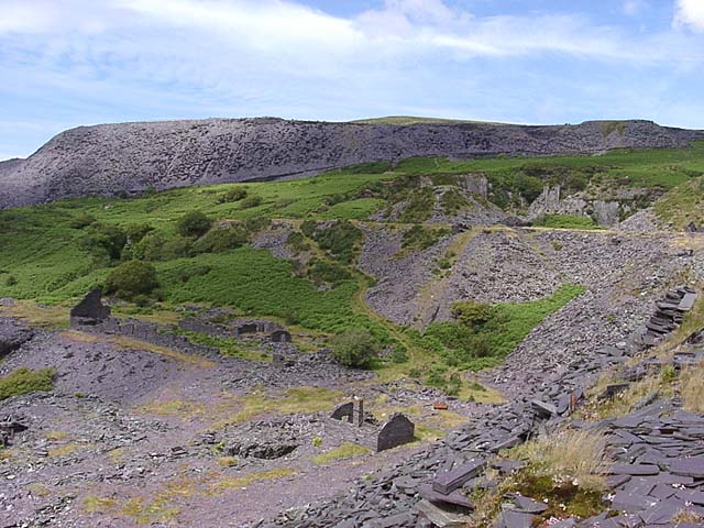
Pen-y-Bryn Quarry takes its name from a 17th-century house that stood on the site, and which continued to be lived in throughout the quarry's working life around it, remaining occupied until after the Second World War. The quarry produced distinctive purple and blue slates, divided by a thin vein of green slate running between them. Between 1836 and 1844, Pen-y-Bryn and Cloddfa'r Lôn, the adjoining workings with which it formed one complex, made use of water-wheel technology, connected by rods to a series of pumps to keep the workings clear of water; both later adopted chain inclines, a technology invented locally, to move slate up and down the steep quarry faces. The complex of buildings used by the quarry's workers survives today almost complete, including their cottages, a saw mill and a weighbridge -- an unusually full survival for a Nantlle Valley slate quarry.
The complex is recorded under two names. Cadw schedules its mill, chain inclines and quarrymen's cottages as Cloddfa'r Lôn Slate Quarry, Wikipedia lists Pen-y-bryn quarry as also known as Cloddfa'r Lôn, and the World Heritage listing names its elements 'Pen y Bryn / Cloddfa'r Lôn'.
Cloddfa'r Lôn was the first major slate quarry on the floor of the Nantlle valley, opened in 1808 by William Turner, who also began Pen-yr-Orsedd about 1816 and, with his son-in-law John Morgan, opened Cloddfa Turner, later Dorothea, in 1829. It was the first quarry linked to the Nantlle Railway when the line opened in 1828, and a pioneer of steam up-haulage, bringing the Cornish chain incline to Wales in 1841: waggons were raised from the quarry pit on an inclined chain. In 1864 it employed 200 men, against 400 each at Dorothea and Pen-yr-Orsedd, and a block of barracks was built at the quarry about 1866.
Substantial investment in the early 1880s developed the mill area on unworkable rock around the existing barracks and Pen y Bryn farm, and in its later years the quarry worked close to the old farmstead. The radial mill built in 1884 held six De Winton saw tables and was driven by a vertical single-cylinder steam engine by W. C. Mather, now at the Welsh Slate Museum in Llanberis and the only slate mill steam engine to survive in Wales. A second chain incline south of the complex was worked by a horizontal steam winding engine, and a tramway crossed the turnpike road on a bridge to reach the Nantlle Railway. The Cloddfa'r Lôn workings fell out of use in 1892; Pen y Bryn closed in 1950.
Geology
Slate of the Nantlle valley, in the Cambrian slate belt of Caernarfonshire. The quarry produced distinctive purple and blue slates divided by a thin vein of green slate between them - the colour banding that made Nantlle slate recognisable - and worked the same ground as its Cloddfa'r Lôn workings, with which it shared its water-wheel drainage. The 1880s mill area was built on unworkable rock around the Pen y Bryn barracks and farm.
Geological setting: Slate and Regional Metamorphism (well documented example)
Workings
Worked for purple and blue slate divided by a thin green vein; drained between 1836 and 1844 by water-wheel-powered pumps, and later served by locally-invented chain inclines to move slate up and down the quarry faces. The Cloddfa'r Lôn workings brought the Cornish chain incline to Wales in 1841; the 1884 mill engine also seems to have driven a chain incline to the north, raising waggons from the pit, and a second incline south of the complex was worked by a horizontal steam winding engine and drum. A tramway bridge over the turnpike road carried slate to the Nantlle Railway, with a weighbridge house to the south.
Closure
Pen y Bryn closed in 1950. The house it was named for outlasted the quarry's working life, having been lived in through it and remaining occupied until after the Second World War. The Cloddfa'r Lôn workings fell out of use in 1892, eighty-four years after they opened and eight years after the 1884 mill was built.
What remains
The quarry lies within the Nantlle Valley Slate Quarry Landscape, Component Part 3 of the Slate Landscape of Northwest Wales World Heritage Site, inscribed in July 2020, and its dwellings, slate mill, chain incline bastions and water-driven pump system are named elements of it. The farmhouse is an unstable ruin; the mill stands roofless among its waste tips. The mill, its chain inclines and the cottages are also scheduled by Cadw as Cloddfa'r Lôn Slate Quarry (CN302, 1998): the mill walls stand complete to eaves height and the boilerhouse chimney is intact.
Unusually complete for a Nantlle quarry: the quarrymen's cottages, a saw mill, a weighbridge, and the roofless slate mill standing among extensive waste tips and the trackbed of its tramway. The late seventeenth-century Pen-y-Bryn farmhouse that gave the quarry its name survives as an unstable ruin, with the row known locally as Alexandra Terrace opposite it. The dwellings, the slate mill and the bastions of the chain incline ropeway are all named elements of the World Heritage Site. The mill is the 1884 radial mill, walls complete to eaves height, with an intact boilerhouse chimney. The engine house and landing strongpoint of the southern chain incline survive, as do the abutments of the tramway bridge over the turnpike road, a weighbridge house, and two rows of barracks, six cottages thought to have been built about 1866, with their garden plots and outbuildings. The mill's steam engine is at the Welsh Slate Museum in Llanberis.
Redevelopment
None: the site is a scheduled monument within the Slate Landscape of Northwest Wales World Heritage Site.
Related mines
- Cloddfacoed Quarry — Neighbours in the same Nantlle ground, 1.3 km apart, both overshadowed by Dorothea. Cloddfa'r Coed should not be confused with Cloddfa'r Lôn, the other name under which this quarry complex is recorded.
- Dorothea Quarry — Both opened by William Turner: Cloddfa'r Lôn in 1808 and Cloddfa Turner, later renamed Dorothea, in 1829.
- Pen-yr-Orsedd Quarry — Both begun by William Turner: Cloddfa'r Lôn in 1808 and Pen-yr-Orsedd about 1816.
Nearby mines
- Pen-yr-Orsedd Quarry — 0.3 miles (0.5 km) E
- Cilgwyn Quarry — 0.3 miles (0.6 km) W
- Tal-y-sarn Quarry — 0.7 miles (1.1 km) W
- Cloddfacoed Quarry — 0.9 miles (1.4 km) SW
- Tymawr West Quarry — 1.0 miles (1.5 km) SW
Straight-line distance, within 9 miles (15 km). Show on the map.
Recorded claims
Individual factual claims, each attached to the source(s) that support it below. Where sources disagree, both are kept.
- Pen-y-Bryn Quarry takes its name from a 17th-century house on the site, which continued to be lived in throughout the quarry's working life and remained occupied until after the Second World War. 1
- The quarry produced distinctive purple and blue slates, divided by a thin vein of green slate between them. 2
- Between 1836 and 1844, Pen-y-Bryn and the neighbouring Cloddfa'r Lon quarry used water-wheel technology connected by rods to pumps; both quarries later used chain inclines, a technology invented locally, to move slate. 2
- The complex of buildings used by the quarry's workers survives today almost complete, including their cottages, a saw mill and a weighbridge. 1
- Pen y Bryn is named twice among the notable elements of the Nantlle Valley Slate Quarry Landscape, Component Part 3 of the Slate Landscape of Northwest Wales World Heritage Site: once for the Pen y Bryn and Cloddfa'r Lon quarry dwellings, slate mill and chain incline ropeway bastions, and again for their water-driven pump system. 3
- Pen y Bryn closed in 1950. 3
- The Pen-y-Bryn farmhouse, now an unstable ruin, dates from the late seventeenth century and was owned by the wealthy Garnons family. Opposite it stand four buildings where quarrymen and their families lived, a row known locally as Alexandra Terrace. 3
- The former farmyard outbuildings were adapted and enlarged in the 1860s as barracks or cottages, built up in slate from the quarry rather than the rough stone of the earlier walls, and fitted with windows, partitions, fireplaces and crog lofts - a first floor running only part way along the interior. 3
- A 2005 photograph records the remains of the slate mill standing among extensive waste tips and the trackbed of the quarry's tramway. 4
- Cloddfa'r Lôn was the first major slate quarry on the floor of the Nantlle valley, worked from 1808 by William Turner, and fell out of use in 1892. 5
- It was the first quarry to be linked to the Nantlle Railway on that line's opening in 1828. 5
- The quarry was a pioneer of steam up-haulage, introducing the Cornish chain incline to Wales in 1841. 5
- Substantial investment in the early 1880s developed the mill area on unworkable rock around an existing barracks and Pen y Bryn farm. 5
- The mill was of radial type, built in 1884 to contain six De Winton saw tables and powered by a vertical single-cylinder steam engine by W. C. Mather, which is now at the Welsh Slate Museum in Llanberis and is the only slate mill steam engine to survive in Wales. 5
- The mill engine seems also to have driven a chain incline to the north, raising waggons from the quarry pit on an inclined chain; a second chain incline south of the complex is evidenced by a surviving engine house, which held a horizontal steam winding engine and a winding drum, and a strongpoint with a landing platform. 5
- The abutments of a bridge carrying a tramway over the turnpike road to the Nantlle Railway survive, with a weighbridge house to the south, and the two rows of barracks consist of six cottages thought to have been built about 1866, complete to eaves height with their garden plots and outbuildings. 5
- The mill, chain inclines and cottages were scheduled on 24 June 1998 as Cadw monument CN302, Cloddfa'r Lon Slate Quarry. 5
- In 1864 Dorothea and Pen-yr-Orsedd quarries each employed four hundred men, while Cloddfa'r Lôn employed two hundred. 2,6
- Pen-y-bryn quarry is also known as Cloddfa'r Lon. 2
- Opened in 1808 by William Turner, Cloddfa'r Lôn remained in production until 1892, in its later years working near an old farmstead known as Penybryn. 6
- A block of barracks was built for Cloddfa'r Lôn about 1866 at the quarry itself. 6
- William Turner also began Pen-yr-Orsedd quarry about 1816 and opened Cloddfa Turner, later Dorothea, in 1829 with his son-in-law John Morgan. 6
Photographs & further reading
A fuller account of the quarry's surviving workers' housing and the 17th-century house that gave the site its name.
View sourceCadw's scheduling text for the mill, chain inclines, bridge abutments, weighbridge house and quarrymen's cottages.
View sourceThe Welsh Government's account of the Nantlle valley component of the Slate Landscape of Northwest Wales World Heritage Site, which names Pen y Bryn's dwellings, slate mill, chain incline bastions and water-driven pump system among its notable elements.
View sourceAn overview of the valley's quarries, listing Pen-y-bryn as also known as Cloddfa'r Lon and giving the 1864 employment figures.
View sourceThe 2017 World Heritage nomination study of Nantlle village, with the quarry's place in William Turner's development of the valley.
View sourceSources
- (secondary) Pen-y-Bryn quarry cottages, Nantlle — History Points
- (secondary) Slate industry in the Nantlle Valley — Wikipedia
- (primary) Dyffryn Nantlle — Slate Landscape of Northwest Wales — Llechi Cymru / Wales Slate (Welsh Government)
- (observational) Pen-y-Bryn Quarry (Geograph 60688) — Geograph Britain and Ireland
- (primary) Cloddfa'r Lon Slate Quarry, Llanllyfni (Cadw scheduled monument CN302) — Cadw scheduling text, via Ancient Monuments UK
- (secondary) Nantlle and Cilgwyn: character study (2017) — Llechi Cymru / Cyngor Gwynedd
Record created: 30 August 2026 · Last researched: 28 September 2026