 MineArchive
New Venture Lead Mine
| Location | Bradwell Moor, a mile west of Bradwell, Derbyshire — 53.3465, -1.7460 (approximate) |
|---|---|
| Commodity | Lead |
| Type | Metal |
| Worked | 18th century–19th century |
| Maximum depth | Unknown. |
Overview
A post-medieval lead rake on Bradwell Moor in the Peak District, worked mainly in the 18th and 19th centuries and left largely undisturbed since, making it one of the better-preserved lead-mining earthwork sites in the district.
History
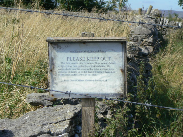
New Venture Mine sits on one of the principal rakes on Bradwell Moor, a mile west of Bradwell, Derbyshire. Its surface remains are typical of 18th- and 19th-century lead mining in the Peak District: a number of open stopes along the line of the rake, a small stone 'bingstead' or ore-house, several capped shafts, and a large area of spoil and ore-processing ground -- including washing ponds and a dewpond -- bounded by a 'belland wall' recorded on early Ordnance Survey maps but since lost above ground. At least one of the site's spoil mounds shows evidence of mechanical 'sparring' -- a small-scale 20th-century rework for residual lead. The Peak District Mines Historical Society carried out consolidation work here in the mid-1990s, capping open shafts and rebuilding the bingstead, and a full measured earthwork survey was carried out in 2009 by Archaeological Research Services Ltd, commissioned as a condition of planning permission for the nearby Hope Quarry.
Geology
A post-medieval lead rake on Bradwell Moor, worked as open stopes along the line of the vein.
Workings
A series of open stopes and shafts along the line of the rake, with ore-washing ponds, a dewpond and waste-spoil mounds bounded by a belland wall to the south; several features were consolidated by PDMHS in the mid-1990s, including the rebuilding of a small stone ore-house or 'bingstead'. A 2009 earthwork survey by Archaeological Research Services Ltd, commissioned by Lafarge Cement UK Ltd as a condition of working the nearby Hope Quarry, recorded capped shafts, open stopes, a small stone 'bingstead' (ore-house) rebuilt during 1990s PDMHS consolidation work, and a belland wall bounding a dewpond and ore-washing ponds to the south of the main rake -- a belland yard boundary visible on early Ordnance Survey maps but since lost above ground until this survey re-identified it.
Closure
The closure date is not known; the site's remains are consistent with a working life through the 18th and into the 19th century, with a small-scale 20th-century rework of the spoil for residual lead.
What remains
Consolidated by PDMHS in the mid-1990s (capped shafts, rebuilt bingstead) and fully surveyed in 2009; the earthworks are considered a relatively intact example of Peak District rake-working, though heavily overgrown.
Open stopes, capped shafts, a rebuilt stone bingstead, ore-washing ponds, a dewpond, and a belland wall bounding the spoil ground.
Nearby mines
- Dirtlow Rake Mine — 0.9 miles (1.5 km) W
- Moss Rake — 0.9 miles (1.5 km) S
- Pin Dale Lead Side Veins — 0.9 miles (1.5 km) SW
- Silence Mine — 0.9 miles (1.5 km) SE
- Speedwell Cavern — 1.9 miles (3.1 km) W
Straight-line distance, within 9 miles (15 km). Show on the map.
Recorded claims
Individual factual claims, each attached to the source(s) that support it below. Where sources disagree, both are kept.
- The Peak District Mines Historical Society carried out consolidation work in the mid-1990s, capping shafts and rebuilding a small stone ore-house ('bingstead'); a full measured earthwork survey followed in 2009. 1
- The site remains heavily overgrown, with surface depressions and hillocks marking former shafts and workings still clearly visible. 2
- The earthworks are typical of 18th-19th century lead mining in the Peak District, and include at least one spoil mound showing evidence of small-scale 20th-century mechanical reworking ('sparring') for residual lead. 1
- A 2009 archaeological earthwork survey recorded capped shafts, open stopes, a rebuilt bingstead, and a previously-lost belland wall bounding a dewpond and washing ponds. 1
Photographs & further reading
The full 2013 academic earthwork survey, cataloguing every surviving feature on site.
View sourceSources
- (primary) Earthwork Survey of Lead Mining Remains at New Venture Mine, Bradwell, Derbyshire — Archaeological Research Services Ltd (Archaeological Research Paper 6, 2013)
- (observational) New Venture Mine (Geograph) — Geograph Britain and Ireland
Record created: 31 August 2026 · Last researched: 1 September 2026