 MineArchive
Mynachdy (Rhosmynach and Carmel Head Copper Mines)
| Also known as | Rhosmynach Mine, Carmel Head Copper Mine, Gaddair Mine |
|---|---|
| Location | Carmel Head, near Cylch-y-Garn, north-west Anglesey — 53.3996, -4.5523 (approximate, low confidence) |
| Commodities | Copper, Chrysotile |
| Type | Metal |
| Worked | From 1839–1926 |
| Maximum depth | Rhosmynach shafts 200 ft deep |
| Operators | Gaddair Copper Mining Company (1839–1845), Edmund Spargo (1863–1908) |
Overview
A remote pair of Anglesey copper workings, named locally after the farmstead at Mynachdy whose leaseholder ran them both — and whose one visible legacy today, a lone stone chimney on the cliffs of Carmel Head, is more often photographed as a coastal landmark than recognised as a mine.
History
Prospecting at Carmel Head, the exposed headland at Anglesey's north-western tip, began with the Gaddair Copper Mining Company, incorporated in 1839. Its prospectus, issued that June, claimed the ground was 'of no less value than the celebrated Parys mine' — a bold comparison to make against the mine that had briefly made Anglesey the world's leading copper producer — and the company sank at least three trial shafts at Pen Bryn yr Eglwys on the headland. The real development came a generation later: in 1863 Edmund Spargo moved into the nearby Mynachdy area and took out leases on both the Rhosmynach and Carmel copper mines, giving the whole enterprise the local name it has carried since. At Rhosmynach three shafts were sunk to 200 feet and three separate lodes discovered, though the lease, running for 45 years, was abandoned well short of its term. Work resumed briefly in 1919 and continued in a small way into the mid-1920s, but Rhosmynach closed for good in the mid-1920s, sources placing the final closure in either 1925 or 1926.
Geology
Carmel Head's copper occurs along an east-west trending vein consisting mainly of quartz with traces of chalcopyrite, terminating in a small cove on the headland. At Rhosmynach, three lodes were identified and assayed: the North lode returned 5.6 per cent copper and the Middle lode as much as 11.37 per cent, figures that would have been genuinely promising had the ground proved consistent, along with minor traces of iron, bismuth, silver and gold recorded in the same assays. A third, geologically quite different working existed at Mynachdy itself: a small quarry, worked at some point before 1919, cut into a small intrusion of serpentinised ultrabasic rock, ophicalcite and altered dolerite, and yielding chrysotile — fibrous serpentine asbestos — described by the geologist Edward Greenly in his 1919 Geological Survey memoir The Geology of Anglesey. It is one of only two confirmed chrysotile localities anywhere in Wales.
Geological setting: Veins and Lodes (well documented example)
Workings
At Carmel Head the Gaddair company's three trial shafts were accompanied by what survives today as a round chimney stack, with the possible remains of pits and a wheel-house nearby. At Rhosmynach, three 200-foot shafts served the workings, supplemented by a sea-level adit reaching in with four deep sinks. The chrysotile quarry at Mynachdy was a separate, much smaller working again, cut directly into the serpentinite rather than following a vein or lode; nothing beyond Greenly's geological description survives to say when it opened or how long it was worked.
Closure
Despite a 45-year lease taken out in 1863, Rhosmynach was abandoned well before its term, though work resumed briefly around 1919 before the mine closed for good in the mid-1920s.
What remains
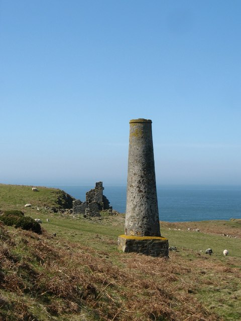
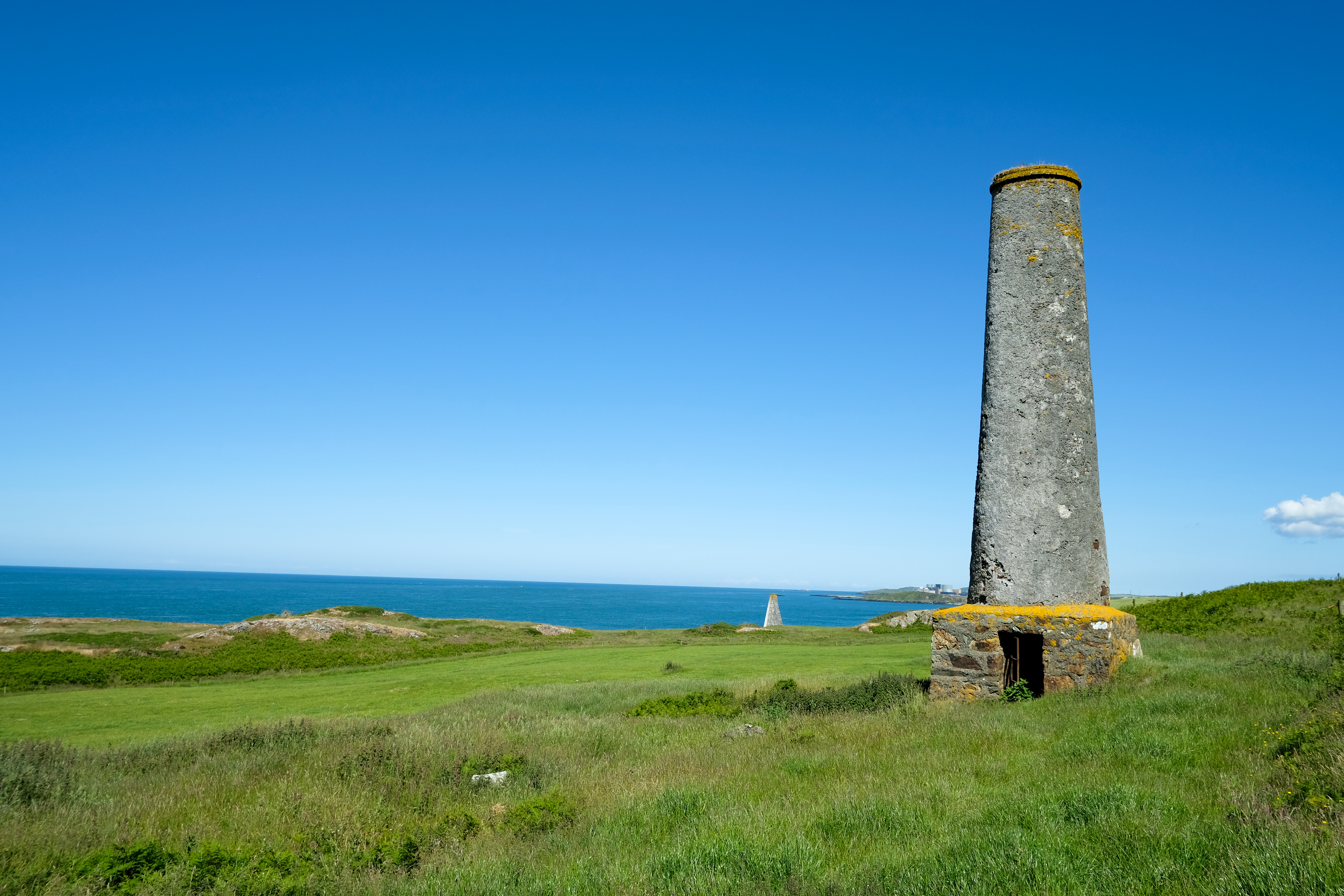
A tapering, rendered stone chimney about 15 metres high survives prominently on the cliffs of Carmel Head, mid-19th century in date and closely associated with the mine buildings that once stood around it; further mine building remains and the site of a wheel-house are traceable nearby. The chimney stands close to the Coal Rock Beacons, the large 1860s navigation towers known locally as the White Ladies, with which it is sometimes confused by walkers on the Anglesey Coastal Path.
A surviving stone chimney about 15 m high, mine building remains, and the probable site of a wheel-house at Carmel Head.
Redevelopment
None — the site lies on open coastal access land on the Anglesey Coastal Path.
Nearby mines
- Morfa Du Mine — 8.0 miles (12.8 km) E
- Parys Mountain — 8.3 miles (13.4 km) E
- Mona Mine — 8.9 miles (14.3 km) E
Straight-line distance, within 9 miles (15 km). Show on the map.
Recorded claims
Individual factual claims, each attached to the source(s) that support it below. Where sources disagree, both are kept.
- The Gaddair Copper Mining Company, incorporated in 1839, sank at least three trial shafts at Pen Bryn yr Eglwys on Carmel Head, its prospectus claiming the ground rivalled Parys Mountain. 1
- Edmund Spargo took out a 45-year lease on the Rhosmynach and Carmel copper mines in 1863 after moving into the Mynachdy area, giving the combined workings their local name. 1,2
- Three shafts at Rhosmynach, sunk to 200 ft, found three lodes: the North lode assayed at 5.6 per cent copper and the Middle lode up to 11.37 per cent, with traces of iron, bismuth, silver and gold also recorded. 1
- A sea-level adit with four deep sinks supplemented the Rhosmynach shafts; at Carmel Head a round chimney stack survives close to the site of the trial shafts and a probable wheel-house. 1
- Despite the 45-year lease, Rhosmynach was abandoned well before its term; work resumed briefly around 1919 before final closure in the mid-1920s (given variously as 1925 or 1926). 1
- A separate small quarry at Mynachdy itself was worked for chrysotile — fibrous serpentine asbestos — from a small intrusion of serpentinised ultrabasic rock, ophicalcite and altered dolerite, described by Edward Greenly in 1919 and one of only two confirmed chrysotile localities in Wales. 3
Sources
- (primary) PUG research — Rhosmynach and Carmel Head Copper Mines — Grwp Tanddaearol PARYS Underground Group
- (secondary) Mynachdy, Cylch-y-Garn — British Listed Buildings / Cadw
- (primary) Chrysotile — Mineralogy of Wales database — National Museum Wales
- (secondary) Carmel Head — penmorfa.com
Record created: 24 August 2026 · Last researched: 24 August 2026