 MineArchive
Muirkirk Collieries
| Location | Muirkirk, upper Ayr valley, East Ayrshire — 55.5184, -4.0669 (exact) |
|---|---|
| Commodities | Coal, Ironstone |
| Type | Coal |
| Worked | 1787–1923 |
| Maximum depth | Shallow pits and levels; the Kames Engine or Glenhead Pit was sunk 20 fathoms in 1790 |
| Operators | Muirkirk Iron Company (1787–1856), Eglinton Iron Company (1856–1923) |
Overview
The coal and ironstone pits sunk around Muirkirk from 1787 to feed the first ironworks in Ayrshire. The works were built in a place its own promoters called a desert, on the strength of nothing but the coal, ironstone and limestone lying under it, and the collieries were the whole reason the village existed. A canal took ore and coal west to the furnaces from Lightshaw, Auldhouseburn and Crossflat; tramways and later a private mineral railway ran the other way to Kames and Wellwood. The blackband ironstone was worked out in 1901 and the ironworks closed in 1923, but coal mining around Muirkirk outlasted it by decades.
History
In 1786 a party from Glasgow travelled to Muirkirk by way of Sorn, testing ironstone and coal as they went, and took samples for analysis. They examined ground on the Kames estate at Ashyburn, Crossflat, Auldhouseburn, Bankend and Kameshill, and found ironstone in the burn at Tordoes. One of them wrote that nothing could induce them to go into such a desert place as Muirkirk but the absolute certainty of having the coal, ironstone and limestone. In August 1787 directions were given to build a furnace and an engine and to have them roofed before winter; the works were founded by John Robertson, John Gillies and Thomas Edington and went into blast in 1788, two years after the neighbouring Muirkirk tar works, which supplied the coke.
The company's own report book, kept until May 1800, records the pits going in one after another. Miners were set to prove the ironstone; a pit was sunk on the West Hill where the vein was found a fathom down; limestone was carted from Crossflat before winter; ironstone was brought from Lightshaw. In 1789 it was resolved to sink the High Weighs Pit down to the level of the Great Mine and to push the level on Tordoes Burn for both coal and ironstone, and in August 1790 to sink the Kames Engine or Glenhead Pit twenty fathoms and drive up the old level to it so as to save pumping water to the surface. A level was being driven to a seam at Glenbuck by October 1791. Three furnaces had been built by June 1796, though only two could be blown at once.
A canal cut about 1790 ran east from the works to provide head water and to serve the collieries; it was replaced much later by Baird's Railway running east to Glenbuck. A tramway system ran west, with an incline down to pits south of the works and a long line out to Wellwood, and there was a private mineral line west to Kames and Wellwood as well. The public railway reached the works in 1848, connecting them to Ayr harbour. The Eglinton Iron Company took the works over in 1856 and sank Kames Colliery, which became the longest-lived pit in the district, just west of them in 1870. The blackband ironstone was exhausted in 1901; imported Spanish ore kept the furnaces going a few years more, but after a strike in 1923 during which the furnaces cooled with the iron still in them they were never reconditioned, and the ironworks closed. Bairds and Dalmellington went on mining in the district afterwards, and the works sidings became the exchange yard for Kames.
Geology
The ground around Muirkirk carries both coal seams and blackband ironstone in the Carboniferous measures, with limestone alongside them — the combination that made an otherwise remote moorland site worth smelting iron on. Ironstone veins at Whitehaugh had been worked earlier by Lord Cathcart. The blackband was the limiting resource: it was worked out by 1901, after which ore had to be brought in from Spain.
Geological setting: Sedimentary Beds and Seams (well documented example)
Workings
The early workings were shallow pits and levels rather than deep shafts, driven into ground already known to carry coal and ironstone near the surface. Water was handled wherever possible by driving a level up to a pit from below rather than pumping to the surface, as at the Kames Engine or Glenhead Pit in 1790. Ore and coal moved by canal east of the works and by tramway west, with an incline serving the pits to the south; these were replaced in turn by Baird's Railway and the private mineral line to Kames and Wellwood.
Closure
The ironworks closed in 1923 after a strike left the furnaces cold with iron inside them, and with the local ore exhausted since 1901 they were not brought back. Mining in the district continued under Bairds and Dalmellington; Kames Colliery, rebuilt in the 1950s, lasted until 1968.
What remains
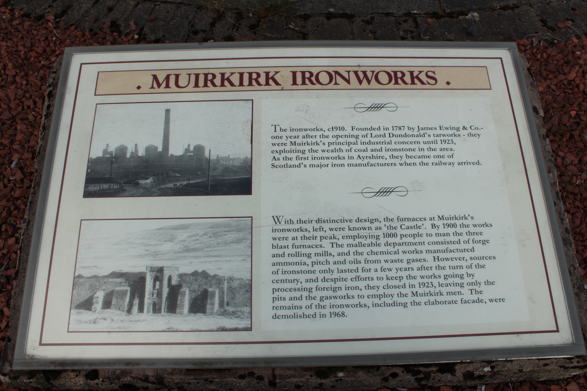
The ironworks were demolished in 1968 and little of them is left, though the remains of the blowing-engine house, the furnace bank and the foundations of three furnaces survive, along with a good deal of the works canal; a 2014 photograph shows what stands at the heritage garden. The ground south of the works is pockmarked with the remains of pits, quarries and tramways. Deep mining is long gone from Ayrshire, but opencast working has continued around the village.
Blowing-engine house remains, furnace bank and the foundations of three furnaces, substantial lengths of the works canal, and the earthworks of pits, quarries and tramways on the moor to the south.
Related mines
- Auldhouseburn Colliery — The Muirkirk Iron Company worked coal and ironstone at Auldhouseburn from the 1780s and its canal ran past the site; this colliery is the later Cairntable Gas Coal Company pit on the same ground.
- Glenbuck Colliery — The Muirkirk company was driving a level to a seam at Glenbuck by October 1791, and the works canal was later replaced by Baird's Railway running east to Glenbuck.
- Hindsward Colliery — Collieries of the Eglinton Iron Company.
- Kames Colliery — Kames was sunk by the Eglinton Iron Company just west of the Muirkirk works in 1870, on the same ground the Muirkirk Iron Company had been working since 1790; the works sidings later became its exchange yard.
Nearby mines
- Auldhouseburn Colliery — 0.5 miles (0.9 km) E
- Kames Colliery — 0.9 miles (1.5 km) S
- Glenbuck Colliery — 3.0 miles (4.9 km) NE
- Grasshill Colliery — 3.6 miles (5.7 km) NE
- Gasswater Mine — 4.0 miles (6.4 km) SW
Straight-line distance, within 9 miles (15 km). Show on the map.
Disasters & major incidents
-
Muirkirk Colliery fall of coal, 1855
1 June 1855 · Collapse / Roof Fall · 2 fatalities
Two men named Gibson were killed together by a fall of coal at the face in the Muirkirk collieries on 1 June 1855.
Recorded claims
Individual factual claims, each attached to the source(s) that support it below. Where sources disagree, both are kept.
- The Muirkirk ironworks were built in 1787 and went into blast in 1788, founded by John Robertson, John Gillies and Thomas Edington; they were the first ironworks in Ayrshire. 1,2
- The company's own correspondence records that nothing could induce them to go to such a desert place as Muirkirk but the certainty of having the coal, ironstone and limestone there. 2
- A canal cut about 1790 ran east from the works and served the Lightshaw, Auldhouseburn and Crossflat mines; a tramway ran west with an incline to pits south of the works and a line to Wellwood, and a private mineral line ran west to Kames and Wellwood. 1
- The blackband ironstone seams were exhausted in 1901; imported Spanish ore sustained the furnaces a few years more before the works closed in 1923 after a strike during which the furnaces cooled with the iron inside them. 1
- The remains of the blowing-engine house, the furnace bank and the foundations of three furnaces survive, with considerable remains of the works canal; the ground to the south is pockmarked with pits, quarries and tramways. 1,3,4
- The BGS mine-plans catalogue holds a Mining Remediation Authority abandonment plan titled 'Muirkirk' (catalogue 7574, Thirty Inch, dated 1922). 5
Photographs & further reading
A long account built from the Muirkirk Iron Company's own report book, naming the individual pits and levels as they were sunk between 1787 and 1800.
View sourceSources
- (observational) Muirkirk Iron Works — Railscot — Railscot
- (secondary) A History of Muirkirk Ironworks — Ayrshire History
- (primary) Muirkirk Ironworks, NRHE 44728 — Historic Environment Scotland
- (observational) Muirkirk Ironworks, at the heritage garden — Geograph Britain and Ireland
- (primary) BGS / Mining Remediation Authority mine plans: MUIRKIRK — British Geological Survey / Mining Remediation Authority
Record created: 9 September 2026 · Last researched: 9 September 2026