 MineArchive
Loggerheads
| Also known as | Cadole Mines, Cathole Mines |
|---|---|
| Location | Loggerheads, near Mold, Denbighshire — 53.1547, -3.2008 (exact) |
| Commodities | Lead, Zinc |
| Type | Metal |
| Worked | worked from at least the 18th century–19th century |
Overview
Loggerheads, now a country park on the River Alyn, was worked for lead and zinc through the 18th and 19th centuries — its old workings, mills and the leat built in 1824 to carry water to the nearby Mold Mines now form the basis of a popular waterside walk.
History
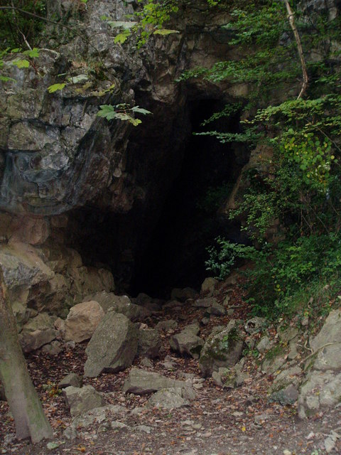
The rich mineral veins in the karstic limestone around Loggerheads were extensively mined for lead, and later zinc, during the 18th and 19th centuries, extracting thousands of tons of ore; the settlement of Cadole was built nearby to house the miners working the district. A leat, or leete, built around 1824, ran along the side of the valley to carry water from the River Alyn to the lead mines at Mold, on land owned by the Grosvenor family, and survives today as the popular Leete Walk. Loggerheads' industrial history has since given way entirely to recreation and conservation, with the site becoming a country park managed around the historic Pentre corn mill and the mine remains scattered through the surrounding woodland. The Cadole mines lay on Mold Mountain, where from 1823 John Taylor amalgamated nearly all the workings into the Mold Mines company; the Leete he dug in 1823-24 kept the pumping wheels down the valley turning when the Alyn sank into its swallow holes, and the mines produced over 7,000 tons of lead ore between 1825 and 1845. Devil's Gorge itself is the result of mining out a wide string off the Pantymwyn vein.
Geology
The district's lead and zinc mineralisation occurs within karstic Carboniferous limestone, part of the wider North Wales orefield that also produced Halkyn Mountain and Minera's lead and zinc.
Geological setting: Hydrothermal Deposits (well documented example), Veins and Lodes (well documented example)
Workings
Ore was worked from veins in the limestone, with water for the district's mines carried some distance by a leat built around 1824 to serve the mines at Mold.
Closure
Mining at Loggerheads had ended by the later 19th century; the exact closure date is not well documented.
What remains
The site is now Loggerheads Country Park, designated a Special Area of Conservation and Site of Special Scientific Interest, managed around Pentre corn mill, woodland walks and the gorge known as Devil's Gorge.
Remnants of the mine workings and mills survive within the country park's woodland, alongside the restored Pentre corn mill and the route of the 1824 leat, now the Leete Walk.
Redevelopment
The Crosville Motor Bus Company acquired land at Loggerheads in 1926 and built tea rooms, gardens, a bandstand and a boating lake for day-trippers arriving by bus, popular through the 1920s and 1930s before declining after the Second World War. Clwyd County Council bought the site in 1974 to establish it as a country park; a wooden tea room burned down in 1984.
Nearby mines
- Hendre Mine — 3.2 miles (5.2 km) N, Flintshire
- Leeswood Main Colliery — 4.7 miles (7.5 km) E, Flintshire
- Milwr Tunnel — 4.6 miles (7.5 km) N, Flintshire
- Leeswood Green Colliery — 4.8 miles (7.7 km) SE, Flintshire
- Pen-y-Bryn Mine — 5.0 miles (8.1 km) N, Flintshire
Straight-line distance, within 9 miles (15 km). Show on the map.
Recorded claims
Individual factual claims, each attached to the source(s) that support it below. Where sources disagree, both are kept.
- A leat built around 1824 carried water from the River Alyn to the lead mines at Mold, and survives today as the Leete Walk. 1,2
- The gorge along the Leete Walk exposes caves and fissures in the limestone, some likely natural in origin but exploited by miners as shaft entrances; the largest is still visible today, though closed off to visitors on safety grounds. 1
- Pentre Mill, the country park's Grade II* listed corn mill, dates to the early 19th century; its waterwheel stopped turning in the 1940s and was restored in the 1990s, and the mill is depicted in an earlier painting of Loggerheads by John Ingleby from 1796. 1
- The name records a dispute: rival holders of shares in the manor of Mold, the 'Lords of Mold', fought over who had the right to win the minerals at the Cathole (Cadole) mines at Loggerheads, the county boundary there being obscure; the boundary stone later set up now stands outside the country park. 3
- The Leete, dug in 1823-24 by John Taylor for the Mold Mines, runs for nearly three miles from Loggerheads to Rhydymwyn so that the waterwheels pumping the mines down the valley kept turning when the Alyn sank into its swallow holes; the mines produced over 7,000 tons of lead ore between 1825 and 1845. 3,4
- Devil's Gorge, the beauty spot on the Leete path, is the result of mining out a wide 'string' off the Pantymwyn vein. 4
- Located at about 53.155 N, 3.201 W. 1
Sources
- (secondary) Loggerheads Country Park — Wikipedia
- (secondary) Loggerheads, Denbighshire — Wikipedia
- (secondary) Lead, a backdrop to Mold, by Diane Johnson (Mold Civic Society) — Mold Civic Society
- (secondary) Discover Gwernaffield and Pantymwyn (Flintshire County Council leaflet) — Flintshire County Council
Record created: 24 August 2026 · Last researched: 24 September 2026