 MineArchive
Llwyngwern Quarry
| Also known as | Glandulas Quarry, Maglona Quarry, Llwyngwern Slate Quarry |
|---|---|
| Location | Pantperthog, near Machynlleth, Powys — 52.6234, -3.8386 (exact) |
| Commodity | Slate |
| Type | Slate |
| Worked | By 1828–1941 |
| Maximum depth | Unknown. |
| Operators | David Lloyd Jones (1878–1891), Maglona Quarries Ltd (1893–1903), Hall Harber & Thomas Ltd (1924–1934) |
Overview
A small Corris-district slate quarry on Mynydd Llwyn-gwern, opened by 1828 and worked in fits and starts through eight owners until 1941. It worked a minor outcrop away from the main veins and never long produced more than two thousand tons a year. Since 1973 the Centre for Alternative Technology has occupied the site.
History
Llwyngwern was working no later than 1828, when Joseph Tyler — son of the manager of Diffwys quarry at Blaenau Ffestiniog — was appointed manager. In 1835 Simon Cook of Llwyngwern is listed as its slate proprietor, but it closed in the 1840s. W. R. Williams of Dolgellau reopened it in 1853, when the Mining Journal called it a long-neglected quarry now reopened and noted a thirty-foot waterwheel driving the mill. The Llwyngwern Slate Quarry Co. Ltd was formed in 1863 under John Lloyd Jones of Nantlle and failed in 1866; H. J. Standly took it on and worked it modestly; by 1878 it was the Llwyngwern Slate and Slab Quarry.
Thirty-five men were working there in 1883, and under David Lloyd Jones the quarry specialised in slab for enamelling, supplied to a London merchant and to a joint venture with the Towyn Enamelled Slate Quarry Company. Jones sold up in 1891, and in 1893 Maglona Quarries Ltd took over — Maglona being the name then commonly given to a supposed Roman fort at Machynlleth. A branch from Llwyngwern station on the Corris Railway reached the quarry in 1896, crossing the Afon Dulas on a timber viaduct, and by 1900 the quarry employed a hundred and forty-four.
Three men were killed here in eleven years. Robert Ellis Jones died in March 1895 when the rock face he was working on collapsed. William Thomas of Abergarfan was killed in March 1903 with injuries the doctor at the inquest said were too frightful to describe; that death brought Board of Trade enquiries and the quarry closed in July, the end of the Maglona company and, since it was the chief industry of the district, a considerable blow — many of the men went to the South Wales coalfield for work. And in 1906 Henry Rees, nineteen, crossing a wooden bridge in the tunnel between the mill and the pit, slipped and fell fifty feet head-first down a shaft.
The quarry reopened in 1905 under D. Hughes with about sixty men, but employment was down to thirty-three by 1909 and the owners closed it in 1910 and auctioned the plant. It reopened in 1920 with eighteen men, was bought by Hall Harber and Thomas Ltd in 1924 and by Grantham Slate Works Ltd in 1934, who closed it in 1937. A new Llwyngwern Slate Quarries Ltd worked it with a handful of men from 1938 until all work stopped in 1941. G. S. Ellison did some work after the Second World War and tried in 1953 to make bricks from ground slate waste, without success; the remaining equipment was scrapped in 1959.
Geology
The quarry worked a minor outcropping of slate on the western flank of Mynydd Llwyn-gwern, away from the main veins quarried to the north around Corris and Aberllefenni. It is the Ordovician slate belt of southern Snowdonia, cleaved by later earth movement so that it splits across the bedding; the Corris district's product was as much slab — for enamelling, cisterns, mantelpieces and worktops — as roofing slate, and Llwyngwern's speciality under David Lloyd Jones was enamelling slab.
Geological setting: Slate and Regional Metamorphism (well documented example)
Workings
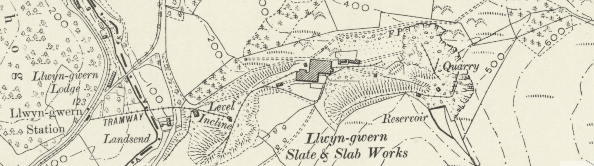
A deep open pit with a mill below it, which is the wrong way round for a slate quarry and cost the company for it. The Ordnance Survey plan of 1888 shows the essentials already there: the stream dammed to make a reservoir and culverted beneath the workings, a large processing mill with a waterwheel against its south-east corner, a row of cottages east of the mill by the Afon Dulas, a magazine in the woods to the north-west, and the pit reached by a level tunnel carrying a tramway. By 1900 a second tunnel had been bored from the bottom of the deepened pit out to the railway branch below mill level, and an incline ran from the mill down to the branch — unusual in having to be powered to lift rock UP to the mill, most quarries being laid out so that the mill sat below the pit. It was a water balance, using large tanks to counterweight the ascending wagons. In 1906 an aerial ropeway was installed to lift waste up the mountainside to a tip south-west of the reservoir, driven by a stationary steam engine at the top; a suction gas engine drove the machinery after 1920.
Closure
All work ceased in 1941 under Llwyngwern Slate Quarries Ltd. G. S. Ellison did some work after the war and the last equipment was scrapped in 1959.
What remains
The site was disused until 1972, when it became the setting for an experiment in green living that grew into the Centre for Alternative Technology, which now occupies much of the quarry. The abutments of the bridge that carried the tramway from Llwyngwern station to the quarry survive.
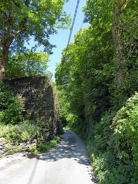
The tramway bridge abutments over the Afon Dulas; the quarry pit and reservoir are within the Centre for Alternative Technology's grounds.
Redevelopment
The Centre for Alternative Technology, an eco-centre with exhibits and displays on sustainable technology, has occupied the site since the early 1970s.
Nearby mines
- Braichgoch Slate Mine — 2.2 miles (3.6 km) N, Gwynedd
- Gaewern Quarry — 2.7 miles (4.3 km) N, Gwynedd
- Abercorris Slate Quarry — 2.7 miles (4.4 km) N, Gwynedd
- Abercwmeiddaw Slate Quarry — 3.0 miles (4.8 km) N, Gwynedd
- Aberllefenni Slate Quarry — 3.7 miles (5.9 km) N, Gwynedd
Straight-line distance, within 9 miles (15 km). Show on the map.
What's uncertain
Points where sources disagree or the record could not be settled; both accounts are kept. All open questions in the archive.
- Wikipedia dates the experiment in green living on the site to 1972; the Royal Commission's record says the Centre for Alternative Technology was founded in 1973. (disputed) 1,3
Recorded claims
Individual factual claims, each attached to the source(s) that support it below. Where sources disagree, both are kept.
- The quarry opened no later than 1828 and worked until about 1950, in the periods 1828-1840s, 1853 to July 1903, 1905-1910, 1920-1937 and 1938-1941. 1
- The Ordnance Survey plan of 1888 shows the stream dammed to form a reservoir, a large processing mill with a waterwheel against its south-east corner, a range of cottages east of the mill, the pit reached by a level tunnel carrying a tramway, and a magazine in the woods north-west of the mill. 2
- Thirty-five men worked here in 1883, a hundred and forty-four in 1900, sixty from 1905, thirty-three by 1909, eighteen in 1920 and twenty-eight in 1931; 1902 was among its most productive years, at 2,087 tons of slab and finished mantlepieces. 1
- The incline from the railway branch up to the mill had to be powered to lift rock uphill, unusual because most quarries put the mill below the pit; it was a water balance using large tanks to counterweight the ascending wagons. 1
- Wikipedia dates the experiment in green living on the site to 1972; the Royal Commission's record says the Centre for Alternative Technology was founded in 1973. (disputed) 1,3
- Robert Ellis Jones was killed in March 1895 when a rock face collapsed; William Thomas of Abergarfan in March 1903, the accident bringing Board of Trade enquiries and the quarry's closure in July; and Henry Rees, aged nineteen, in 1906, falling fifty feet head-first down a shaft from a wooden bridge in the tunnel. 1
Photographs & further reading
The Royal Commission's site record — grid reference, the ownership sequence from 1835, and a reading of the 1888 Ordnance Survey plan showing the reservoir, mill, waterwheel, cottages, tunnel and magazine.
View sourceA year-by-year account of eight owners, the Corris Railway branch, the water-balance incline and aerial ropeway, the three fatal accidents and the site's reuse.
View sourceSources
- (secondary) Llwyngwern quarry — Wikipedia
- (primary) Llwyngwern Slate Quarry, NPRN 407582 — Coflein, Royal Commission on the Ancient and Historical Monuments of Wales
- (primary) Centre for Alternative Technology, Llwyngwern Quarry, Machynlleth, NPRN 302254 — Coflein, Royal Commission on the Ancient and Historical Monuments of Wales
Record created: 9 September 2026 · Last researched: 9 September 2026