 MineArchive
Lepton Edge Colliery
| Location | Wakefield Road, east of Lepton, near Huddersfield, West Yorkshire — 53.6343, -1.6801 (exact) |
|---|---|
| Commodity | Coal |
| Type | Coal |
| Worked | By 1894–August 1964 |
| Maximum depth | Unknown. |
| Operators | W. and J. Cardwell (1894–?), Elliott's Collieries Ltd (?–1947), National Coal Board (1947–1964) |
Overview
A colliery on Wakefield Road east of Lepton, near Huddersfield, worked from 1894 to 1964 by the Cardwells, Elliott's Collieries and the National Coal Board, and later used as a pumping station.
History
Lepton Edge Colliery stood on Wakefield Road east of Lepton, between Huddersfield and Wakefield. It appears on the Ordnance Survey map of 1892 and in the returns from 1894, when W. and J. Cardwell worked it with 147 people for household and manufacturing coal. It never employed fewer than about a hundred: the Blocking and Lime coals in 1905, the Blocking, Lime and Shertcliffe in 1910, the Blocking and Crown in 1915.
Later owned by Elliott's Collieries Ltd of Hopton, it grew in the late 1930s, to 170 in 1937 and 203 in 1940, and 212 men worked underground in 1945. At nationalisation in 1947 it reached its peak, 290 people and 84,000 tons of gas, household and steam coal, and it was known for raising more water than coal. By 1954 it was in the Beeston and New Hards seams with 268 men. Both were abandoned on 7 August 1964, when the colliery closed. From 1968 to 1988 the shaft served as a pumping station. In 2021 the old winding house still stood beside the capped shaft.
Geology
West Yorkshire coal measures: the Blocking, Lime, Shertcliffe and Crown coals, and later the Beeston and New Hards seams; the workings were notably wet.
Workings
A shaft colliery with a winding house; the shaft was used as a pumping station from 1968 to 1988.
Closure
Closed in August 1964; the Beeston and New Hards were abandoned on 7 August 1964.
What remains
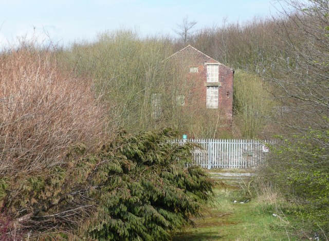
The old winding house still stands beside the capped shaft (2021).
The red-brick winding house.
Nearby mines
- Shuttle Eye Colliery — 0.7 miles (1.1 km) E
- Grange Ash Colliery — 1.1 miles (1.7 km) E
- Flockton Collieries — 2.0 miles (3.2 km) E
- Emley Moor Colliery — 2.2 miles (3.5 km) SE
- Denby Grange Colliery — 2.3 miles (3.7 km) E
Straight-line distance, within 9 miles (15 km). Show on the map.
Recorded claims
Individual factual claims, each attached to the source(s) that support it below. Where sources disagree, both are kept.
- Lepton Edge worked from 1894 until August 1964. 1,2,3
- Its owners were W. and J. Cardwell, then Elliott's Collieries Ltd of Hopton, and from 1947 the National Coal Board. 3,4
- In 1947 it employed 290 people and raised 84,000 tons of coal. 3,5
- Its Beeston and New Hards workings were abandoned on 7 August 1964. 6,7
- The shaft was used as a pumping station from 1968 to 1988. 2
- In 2021 the old winding house still stood beside the capped shaft. 5
Sources
- (secondary) NCB Collieries - England (Northern Mine Research Society) — Northern Mine Research Society
- (secondary) Yorkshire coal mines list, L — Northern Mine Research Society
- (primary) Durham Mining Museum: Lepton Edge Colliery — Durham Mining Museum
- (observational) Building in former coal mine, Wakefield Road, Lepton (Humphrey Bolton, 2008) — Geograph
- (observational) Flockton Lane End Colliery/Lepton Edge Colliery, West Yorks, June 2021 — Derelict Places
- (primary) BGS mine plan: LEPTON EDGE, Beeston, abandoned 7 August 1964 — British Geological Survey / Mining Remediation Authority
- (primary) BGS mine plan: LEPTON EDGE, New Hards, abandoned 7 August 1964 — British Geological Survey / Mining Remediation Authority
Record created: 24 October 2026 · Last researched: 24 October 2026