 MineArchive
Hafod y Llan Copper Mine
| Also known as | Hafod-y-Llan Mine |
|---|---|
| Location | Cwm Llan, Hafod y Llan, Nant Gwynant, Beddgelert, Gwynedd — 53.0474, -4.0570 (approximate) |
| Commodities | Copper, Lead |
| Type | Metal |
| Worked | By 1825–1880s |
| Maximum depth | Unknown. |
Overview
A copper and lead mine in Cwm Llan on the southern slopes of Snowdon, selling ore at Swansea from 1825 and often worked with its neighbour Braich yr Oen until the 1880s.
History
Hafod y Llan copper mine lay in Cwm Llan, the valley that climbs from Nant Gwynant towards Snowdon, on the Hafod y Llan farm that shares its name with the slate quarry higher up the cwm. It worked a vein reported to be three fathoms wide and was often worked together with the neighbouring Braich yr Oen mine. Ore from the mine was sold at Swansea in 1825-26 and again in 1840, and in 1847 it raised 150 tons of copper and 30 tons of lead.
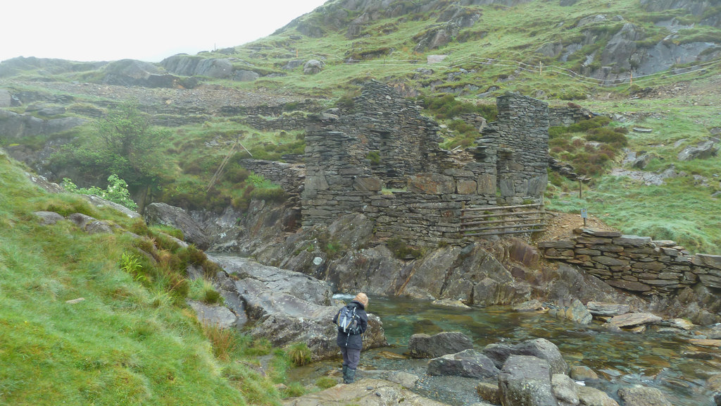
Allen Searell, a Devon man who came to Beddgelert in 1841 to develop mining and worked copper at Sygun and slate at Cwm Orthin, speculated successfully at Hafod y Llan, both in the slate quarry and in the copper mine of the same name; he died in 1865. Working continued into the 1880s. Ruined mine buildings survive by the Afon Cwm Llan below the workings on the slopes of Y Lliwedd. One account calls this riverside site the Lliwedd Copper Works, active in the 1820s and 1830s, where water power drove the ore-dressing machinery; the leat, wheel pit and crushing floor remain, with ruined offices and barracks, and a tramway with stone sleeper blocks of about four-foot gauge climbs the opposite hillside on an incline.
Geology
A copper vein, with some lead, reported to be three fathoms wide.
Workings
Unknown.
Closure
Work ended in the 1880s.
What remains
Ruined mine buildings stand by the Afon Cwm Llan, below the workings on the slopes of Y Lliwedd.
Ruined offices and barracks by the Afon Cwm Llan, with the leat, wheel pit and crushing floor of the water-powered dressing works, and an early tramway incline with stone sleeper blocks.
Redevelopment
National Trust land on the Hafod y Llan farm, within Eryri National Park.
Related mines
- Braich yr Oen Mine — Neighbouring Cwm Llan copper mines, often worked together.
- Hafod y Llan Slate Quarry — Copper mine and slate quarry of the same name in Cwm Llan, both worked by Allen Searell.
- Hafod y Porth Copper Mine — In Hafod y Porth's last years its ore was taken over the pass to the Hafod y Llan mill.
- Lliwedd Mine — Copper mines on the Hafod y Llan land in Cwm Llan, under Y Lliwedd.
Nearby mines
- Braich yr Oen Mine — 0.3 miles (0.4 km) W
- Hafod y Llan Slate Quarry — 0.6 miles (1.0 km) NW
- Lliwedd Mine — 1.0 miles (1.6 km) NE
- Hafod y Porth Copper Mine — 1.0 miles (1.7 km) SW
- Britannia Copper Mine — 2.1 miles (3.4 km) NE
Straight-line distance, within 9 miles (15 km). Show on the map.
What's uncertain
Points where sources disagree or the record could not be settled; both accounts are kept. All open questions in the archive.
- The derelict works beside the Afon Cwm Llan, described as the Lliwedd Copper Works and active in the 1820s and 1830s, used water power to drive ore-dressing machinery; the leat, wheel pit and crushing floor survive. (uncertain) 3
Recorded claims
Individual factual claims, each attached to the source(s) that support it below. Where sources disagree, both are kept.
- Hafod y Llan ore was sold at Swansea in 1825-26 and in 1840, and in 1847 the mine raised 150 tons of copper and 30 tons of lead. 1
- Hafod y Llan was often worked together with Braich yr Oen, from 1825 into the 1880s. 1
- Allen Searell, who came to Beddgelert in 1841, speculated successfully at Hafod-y-llan, in both the slate quarry and the copper mine of that name. 2
- The Hafod y Llan vein was reported to be three fathoms wide. 1
- The derelict works beside the Afon Cwm Llan, described as the Lliwedd Copper Works and active in the 1820s and 1830s, used water power to drive ore-dressing machinery; the leat, wheel pit and crushing floor survive. (uncertain) 3
Sources
- (secondary) Hafod y Llan (Buddlepit Mine Database) — Buddlepit Mine Database
- (secondary) Allen Searell — Festipedia (FR Heritage Group)
- (secondary) Llanberis, Snowdon and Nant Gwynant (Section 21) — Jaggers Heritage
Record created: 19 October 2026 · Last researched: 19 October 2026