 MineArchive
Gravel Hill Mine
| Also known as | Penhale Iron Mine, Cliff Iron Mine |
|---|---|
| Location | North-east corner of Perran Sands, about 3.5 km north of Perranporth, Perranzabuloe, Cornwall — 50.3753, -5.1454 (approximate) |
| Commodities | Iron, Zinc |
| Type | Iron |
| Worked | By 1728 (c. 1840 by one account)–1882 |
| Maximum depth | 60 fathoms (Borlase's shaft; lode proven to 60 fathoms) |
| Operators | Cornish Consolidated Iron Mines Corporation (1872–1877), Great Perran Iron Ore and Iron Company (1877–1878), New Perran Mineral Company (1878–1882) |
Overview
An iron mine in the cliffs at the north end of Perran Sands, where the Great Perran Iron Lode, one of the largest lodes in south-west England, meets the sea. Worked from the 1720s and last in 1874-82, when the Cornwall Minerals Railway ran a branch to it, it is known to mineralogists for its rare iron phosphates.
History
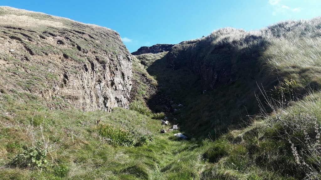
Gravel Hill Mine worked the western end of the Great Perran Iron Lode where it outcrops in the cliffs at the north-east corner of Perran Sands, about 3.5 km north of Perranporth. The lode, one of the largest in south-west England, runs north-west to south-east for 5 km or more and is up to 30 metres wide, unusually for Cornwall at almost right angles to the tin and copper lodes; at Gravel Hill it splits into a north branch and a south branch separated by killas, and is proven to 60 fathoms. Known first as Penhale Iron Mine, or Cliff Iron Mine, it was at work before 1728 by one account (from 1724 by another), though the Geological Conservation Review dates Penhale Iron Mine's operations from about 1840; it worked again in the 1840s. The lode was developed by a beach adit and cliff-top shafts, among them Borlase's (60 fathoms) and Shepherd's, and inland by a small, deep opencast, the Big Iron Pit, about 155 metres to the south-east. By the 1860s an 11.5-inch puffer engine worked an incline down to the main entrance, and ore was taken to the Gannel for shipment. In 1872 the mine belonged to the Cornish Consolidated Iron Mines Corporation, and from 1874 to 1888 it was the terminus of the Cornwall Minerals Railway's branch from Shepherd's; it passed to the Great Perran Iron Ore and Iron Company in 1877 and to the New Perran Mineral Company by 1878. Output is recorded only for 1874-82, about 7,400 tons of brown haematite, 300 tons of limonite and spathic ore and 30 to 40 tons of zinc ore, and more than 35,000 tons of spathic ore are said to have been raised over the mine's life. The gossany head deposit below the opencast is known for rare iron phosphate minerals, and the mine is the type locality of ferroberaunite.
Geology
The north-west end of the Perran Iron Lode, a brecciated fault-hosted lode in Lower Devonian Meadfoot Group slates (killas): siderite with black sphalerite, oxidised near surface to haematite, goethite and limonite to about 60 m, cut by later north-south cross-courses with argentiferous galena. At Gravel Hill it is split into a north branch (about 4 m) and a south branch (about 12 m).
Geological setting: Faults and Fractures (well documented example), Veins and Lodes (well documented example)
Workings
A beach adit and cliff-top shafts, including Borlase's (60 fathoms) and Shepherd's, with open stoping of the lode in the cliff and a small, deep opencast, the Big Iron Pit, about 155 metres inland. An 11.5-inch puffer engine worked an incline to the main entrance in the 1860s, and there were at least two engine houses.
Closure
Output is recorded until 1882, and the mine was probably abandoned then; the railway branch that served it was used until 1888. By 1892 most of the Perran iron mines had stopped because of the low price of iron.
What remains
Scant remains survive in the cliff at the north end of Perran Beach; the cliff workings are partly flooded and drain copious mine water, and by 2004 little remained of either engine house. The site is a Geological Conservation Review site for its mineralisation.
The cliff opencast, adit entrances at beach level, the line of the incline and slight remains of an engine house; the railway line is roughly followed by the road through the dunes.
Nearby mines
- Cligga Head — 4.8 km SW
- East Wheal Rose — 5.8 km NE
- West Chiverton Mine — 7.3 km SE
- Penhalls Mine — 7.7 km SW
- Wheal Kine — 7.7 km SW
Straight-line distance, within 15 km. Show on the map.
What's uncertain
Points where sources disagree or the record could not be settled; both accounts are kept. All open questions in the archive.
- Originally known as Penhale Iron Mine, Gravel Hill is known to have been at work before 1728, also in the 1840s, and from 1874-82. (disputed) 1
- Gravel Hill Mine was first known as Penhale Iron Mine, with operations commencing about 1840. (disputed) 2
- The last working produced about 8,000 tons of iron ore and 30 tons of zinc ore, and more than 35,000 tons of spathose ore were raised during the mine's life. (disputed) 1
Recorded claims
Individual factual claims, each attached to the source(s) that support it below. Where sources disagree, both are kept.
- Originally known as Penhale Iron Mine, Gravel Hill is known to have been at work before 1728, also in the 1840s, and from 1874-82. (disputed) 1
- Gravel Hill Mine was first known as Penhale Iron Mine, with operations commencing about 1840. (disputed) 2
- In 1872 the mine belonged to the Cornish Consolidated Iron Mines Corporation and was reached by the Cornwall Minerals Railway's Shepherd's to Gravel Hill branch, built in 1874 and used until 1888; from 1877 it was owned by the Great Perran Iron Ore and Iron Company and by 1878 by the New Perran Mineral Company. 3
- Output in 1874-82 was 7,400 tons of brown haematite, 300 tons of mixed limonite and 30 tons of zinc ore. 2
- The last working produced about 8,000 tons of iron ore and 30 tons of zinc ore, and more than 35,000 tons of spathose ore were raised during the mine's life. (disputed) 1
- The lode is proven to 60 fathoms and split into a North Branch and a South Branch separated by a 'horse' of killas; it was developed by a beach adit and cliff-top shafts and worked 155 metres inland in the Big Iron Pit. 1,2
- The Perran Iron Lode strikes WNW-ESE for almost 5 km from the coast at Gravel Hill, dips south-west and is up to 20 m wide; its siderite is altered by supergene activity to limonite and haematite to depths of up to 70 m. 4
- The head deposit below the opencast contains rare iron phosphates including rockbridgeite, strengite, strunzite and beraunite; the mine is the type locality of ferroberaunite. 2,5
Photographs & further reading
The GCR site account of the Perran Iron Lode at Gravel Hill: structure, mineralogy and output.
View sourceOwners, the railway branch, shafts and output, with references.
View sourceThe great iron lode and the other mines that worked it.
View sourceSources
- (secondary) Gravel Hill Mine, Cornwall — Cornwall Calling
- (secondary) Gravel Hill Mine, Cornwall (Geological Conservation Review, Mineralization of England and Wales, GCR vol. 36) — JNCC / Scottish Geology Trust GeoGuide
- (secondary) Gravel Hill Mine — Explore Cornwall
- (secondary) Perran Iron Lode, Cornwall — Cornwall Calling
- (observational) Gravel Hill Mine, Perran Iron Lode, Perranzabuloe, Cornwall — Albion Fire and Ice
Record created: 18 September 2026 · Last researched: 19 September 2026