 MineArchive
East Van Mine
| Also known as | Van East Mine |
|---|---|
| Location | North of Nant Gwden, about 4 km north of Llanidloes, Llanidloes Without, Powys — 52.4843, -3.5491 (exact) |
| Commodity | Lead |
| Type | Metal |
| Worked | 1870–1882 |
| Operators | East Van Mining Company Ltd (1870–1882) — Sank the shafts, drove the levels and installed the horizontal engine of 1871. |
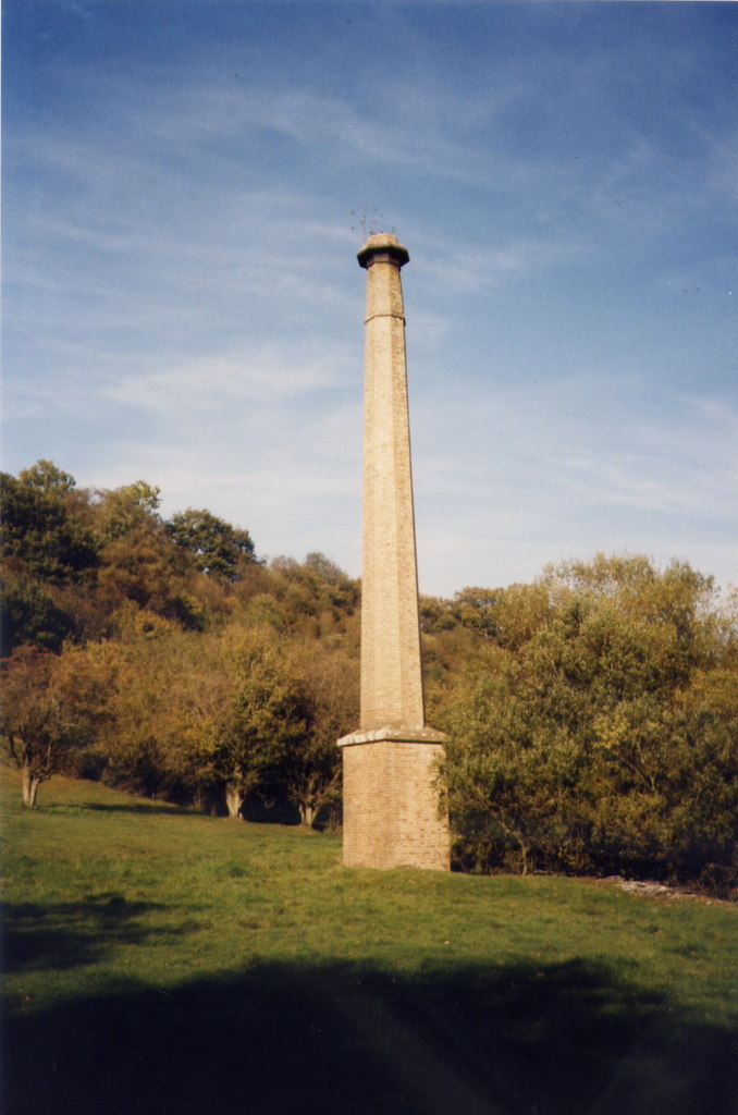
East Van was a lead trial on the eastward run of the Van lode, three-quarters of a mile east of the Van mine and about four kilometres north of Llanidloes. The East Van Mining Company worked it from 1870 to 1882, sinking shafts and driving a great length of levels behind a steam engine installed in 1871. The lode that had made the Van rich was all but barren here, and only 21 tons of lead ore were ever returned. The engine's brick chimney still stands to full height.
Location
Recorded location. The large pin is this mine; the small round markers are the nearest mines on record. Click one for its page. View on full map
History
The Van mine, on the next ground west, was in the 1870s the most productive lead mine in Europe, and East Van was an attempt to find the same lode beyond it. The East Van Mining Company was at work from 1870. A horizontal steam engine with a 24-inch cylinder and a four-foot stroke was put in during 1871, with a boiler 30 feet long, and was at work by April 1872.
The search was thorough. Two shafts were sunk to test the lode and a great length of drivage was carried out, with a long adit and four levels opened along the slopes north of Nant Gwden. All of it proved abortive. The lode ran on between the Gwestyn shales and the lower Frongoch beds as it should, but carried next to nothing, and the mine's entire return was 21 tons of lead ore in 1880. The company's work ended in 1882.
Geology
The mine lies on the eastern extension of the main Van lode, bounded on the north by the Gwestyn shales and on the south by the lower beds of the Frongoch formation. It is a point of some note that a lode so rich in the adjoining ground to the west should be all but barren here.
Geological setting: Veins and Lodes (well documented example)
Workings
Three shafts, a long adit and four levels lie on the slopes north of Nant Gwden. The engine shaft, now filled with debris, stands south of the winding pit of the engine house, among large spoil tips, and a level runs north into the hillside behind the chimney.
Closure
The only return of ore is for 1880; the company's activity ended in 1882.
What remains
The octagonal brick chimney, on a square plinth, stands to its full height. The engine house survives only to the level of the engine plinth. The brick stables, possibly also the smithy, are intact and in farm use with a modern extension.
The chimney; the footings of the engine and boiler houses, about 15 metres by 11, of local shale with brick quoins, with a flywheel pit and four iron holding-down rods; a masonry bob pit; a levelled platform that may have been the coal store; the filled engine shaft and its tips; and the stables.
Redevelopment
The mine stables are in agricultural use.
Related mines
- Van Mine — East Van was sunk and driven on the eastward continuation of the Van lode, three-quarters of a mile beyond the Van mine, to find the ore the Van was working.
Nearby mines
- Van Mine — 0.7 miles (1.1 km) S
- Penyclun Mine — 1.4 miles (2.2 km) SW
- Aberdaunant Mine — 2.0 miles (3.2 km) SW
- Bryntail Lead Mine — 2.4 miles (3.9 km) SW
- Gorn Mine — 3.4 miles (5.5 km) SE
Straight-line distance, within 9 miles (15 km). Show on the map.
Further reading
The archaeological trust's survey and its later ground survey of the engine house, boiler house and chimney.
View sourceSources
- (secondary) Powys Metal Mines Survey: East Van (HER 5937) — Clwyd-Powys Archaeological Trust, Powys Metal Mines Survey
- (primary) Lead and Zinc: The Mining District of North Cardiganshire and West Montgomeryshire (Special Reports on the Mineral Resources of Great Britain, vol. XX), O. T. Jones, 1922 — Memoirs of the Geological Survey
- (secondary) Powys Metal Mines Survey: introduction — Clwyd-Powys Archaeological Trust, Powys Metal Mines Survey
- (observational) Chimney, East Van Mine (Geograph photograph 2618258, 2011) — Geograph
Record created: 18 November 2026 · Last researched: 18 November 2026