 MineArchive
East Cramlington Colliery
| Also known as | Dicky Pit |
|---|---|
| Location | East Cramlington, Cramlington, Northumberland — 55.0737, -1.5795 (approximate) |
| Commodity | Coal |
| Type | Coal |
| Worked | By 1848–c. 1939 |
| Maximum depth | Unknown. |
| Operators | Lamb, Potter and Scott, Hartley Main Collieries Ltd |
Overview
A colliery at East Cramlington, on the east side of Cramlington, at work by the 1840s, owned by Lamb, Potter and Scott in the 1860s and later one of the Hartley Main company's Cramlington pits; it closed about 1939, and its pit heap is now a nature reserve.
History
East Cramlington Colliery lay at East Cramlington, on the east side of Cramlington, about seven and a half miles north of Newcastle. Its Dicky Pit is shown on the first edition Ordnance Survey map, published in 1865. Lamb, Potter and Scott owned the colliery in the 1860s, and the returns record coal raised there in 1855, 1860 and 1865.
Fifteen deaths are recorded at the colliery between 1848 and 1897, almost all of them single accidents. William Tranint, 18, was drawn into the machinery and crushed in February 1848. Several of the dead were boys: Alexander Johnson, a trapper of 13, was killed when a trap door fell on him in 1851, and Stephen Huckup, a driver of 12, was caught by a rope in 1855. Seven were killed by falls of stone. In 1897 James Harding, a deaf striker of 67, was knocked down by an engine he had not heard as he crossed the line from the pit to the blacksmiths' shop.
Hartley Main Collieries Ltd later took the colliery over, and it was counted as one of the pits of Cramlington Colliery. Plans of the Beaumont seam workings join East Cramlington with Seghill and West Cramlington. The pit closed about 1939, but coal from the company's other pits nearby was processed there for another twenty years, and a very large heap of waste grew up. The site is now East Cramlington Nature Reserve, a landscaped area of woods and a large pond.
Geology
The Beaumont seam was worked here, as at Seghill and West Cramlington.
Workings
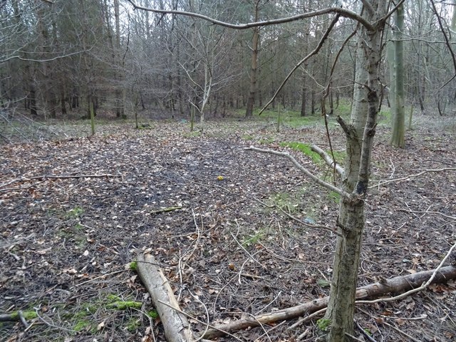
The Dicky Pit, shown on the 1865 Ordnance Survey; its capped shaft lies in a clearing in woodland.
Closure
The pit closed about 1939; the site went on processing coal from other Hartley Main pits for some twenty years.
What remains
The site is woodland within East Cramlington Nature Reserve.
A clearing in young woodland marks the capped shaft; the former waste heap has been landscaped.
Related mines
- Cramlington Colliery — Hartley Main Collieries Ltd owned both, and Co-Curate counts East Cramlington among the pits of Cramlington Colliery.
- Seghill Colliery — Shared plan: the BGS plans of the Beaumont seam join East Cramlington's workings with Seghill's.
- West Cramlington Colliery — Shared plan: the BGS plans of the Beaumont seam take in both East and West Cramlington with Seghill.
Nearby mines
- West Cramlington Colliery — 0.4 miles (0.6 km) NW
- Cramlington Colliery — 0.8 miles (1.3 km) NE
- Dudley Colliery — 1.2 miles (2.0 km) SW, Tyne and Wear
- Nelson Colliery — 1.5 miles (2.5 km) N
- Burradon Colliery — 1.6 miles (2.6 km) S
Straight-line distance, within 9 miles (15 km). Show on the map.
Recorded claims
Individual factual claims, each attached to the source(s) that support it below. Where sources disagree, both are kept.
- East Cramlington Colliery's Dicky Pit is shown on the first edition Ordnance Survey map of 1865. 1,2
- Lamb, Potter and Scott owned East Cramlington Colliery in the 1860s. 1,2
- Fifteen deaths are recorded at East Cramlington Colliery between 1848 and 1897. 1
- Taken over by Hartley Main Collieries Ltd, the pit closed about 1939, and coal from other pits was processed on the site for twenty years more. 3
Photographs & further reading
Newcastle University's page on the village, the colliery and the nature reserve on its waste heap.
View sourceSources
- (primary) East Cramlington Colliery — Durham Mining Museum
- (secondary) East Cramlington Colliery (Dicky's Pit) — North East Heritage Library (Coals Archive)
- (secondary) East Cramlington (Co-Curate) — Co-Curate, Newcastle University
Record created: 23 October 2026 · Last researched: 23 October 2026