 MineArchive
Dullatur Colliery
| Location | Dullatur, near Cumbernauld, North Lanarkshire — 55.9725, -4.0033 (exact) |
|---|---|
| Commodity | Coal |
| Type | Coal |
| Worked | 1935 (earlier workings by 1899)–May 1964 |
| Maximum depth | Two drifts, each 220 m long, at 1 in 5 and 1 in 4 |
| Operators | Cadzow Coal Co., Ltd (1935–1947), National Coal Board (1947–1964) |
Overview
The Cadzow Coal Company's anthracite colliery at Dullatur, near Cumbernauld, opened in 1935 with two inclined drift mines, each 220 metres long. Taken over by the National Coal Board, it grew to 281 men in 1963 and closed in May 1964; its brick surface buildings still stand.
History
Dullatur lies in the parish of Cumbernauld, north-east of Glasgow. Coal had been worked here before: plans of Dullatur workings in the Upper, Main and Possil coals were abandoned in 1899 and between 1913 and 1914. The Cadzow Coal Company opened the colliery of the twentieth century in 1935, as two surface mines each 220 metres long, No. 1, the downcast, at a gradient of 1 in 5 and No. 2, the upcast, at 1 in 4. It produced anthracite, and employed 121 people in 1937 and 1940.
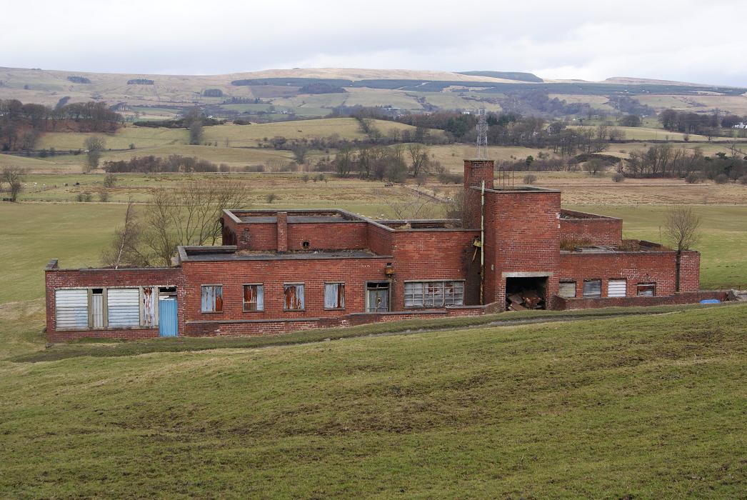
In 1948, under the National Coal Board, Dullatur raised 60 tons a day, 16,200 tons a year, with 97 employees; it had no washer, but had baths, a canteen and a first-aid room, and took its electricity from the Scottish Central Supply. It grew through the 1950s, working the Main coal, to 210 people in 1954 and a peak of 281 in 1963. The First Possil workings were abandoned in 1960 and the Meiklehill Main in 1964, and the colliery closed in May 1964. Its brick surface buildings survive among the fields.
Geology
Central coalfield: anthracite from the Main and Meiklehill Main, the First Possil, and earlier the Upper and Chapelgreen coals.
Workings
Two surface mines (drifts), each 220 m: No. 1 downcast at 1 in 5 and No. 2 upcast at 1 in 4; baths and a canteen; no washer.
Closure
Closed by the National Coal Board in May 1964; the Meiklehill Main plan is dated 1964.
What remains
The colliery's flat-roofed brick surface buildings survive in fields, disused, with a large bing nearby.
Brick surface buildings and a bing.
Redevelopment
Unknown.
Related mines
- Cadzow Colliery — Both worked by the Cadzow Coal Company.
Nearby mines
- Banknock Colliery — 2.4 miles (3.9 km) NE, Falkirk
- Dumbreck Colliery — 3.1 miles (4.9 km) W
- Bedlay Colliery — 4.6 miles (7.4 km) S
- Auchinreoch Colliery — 4.7 miles (7.6 km) W, East Dunbartonshire
- Gartshore Colliery — 5.0 miles (8.1 km) W, East Dunbartonshire
Straight-line distance, within 9 miles (15 km). Show on the map.
Recorded claims
Individual factual claims, each attached to the source(s) that support it below. Where sources disagree, both are kept.
- Dullatur Colliery was opened by the Cadzow Coal Company in 1935 to work anthracite. 1,2
- It had two surface mines each 220 m long, No. 1 downcast at 1 in 5 and No. 2 upcast at 1 in 4. 1
- Dullatur employed 121 people in 1937 and 210 in 1954. 3
- In 1948 it produced 60 tons a day, 16,200 tons a year, with 97 employees. 1
- Dullatur closed in May 1964; the workforce had peaked at 281 in 1963. 4,1,5
- Plans of earlier Dullatur workings in the Upper and Main coals were abandoned in 1899. 6
Photographs & further reading
The national record of the two drift mines and their 1948 details.
View sourceSources
- (secondary) Dullatur Colliery (NRHE 130831) — Historic Environment Scotland (trove.scot, formerly Canmore)
- (observational) Dullatur Colliery Building (Commons, from Geograph 1763448) — Wikimedia Commons
- (primary) Dullatur Colliery — Durham Mining Museum
- (secondary) NCB Collieries - Scotland (Northern Mine Research Society) — Northern Mine Research Society
- (primary) BGS mine plan: Dullatur, Meiklehill Main, abandoned 1964 — BGS / Mining Remediation Authority mine plans
- (primary) BGS mine plan: Dullatur, Upper & Main, abandoned 1899 — BGS / Mining Remediation Authority mine plans

Record created: 4 October 2026 · Last researched: 4 October 2026