 MineArchive
Drumgrange Pits
| Also known as | Drumgrange Colliery, Drumgrange Ironstone Pits |
|---|---|
| Location | Drumgrange, Lethanhill plateau, east of Patna, Dalmellington, East Ayrshire — 55.3514, -4.4691 (approximate) |
| Commodities | Ironstone, Coal |
| Type | Ironstone |
| Worked | c. 1852–1904 |
| Operators | Dalmellington Iron Company (1852–1921) — Owner of every Drumgrange pit and the incline (DMM d250; RAILSCOT; BGS plans) |
The Dalmellington Iron Company's numbered ironstone pits on the plateau above Waterside, east of Patna, worked from the 1850s and reached by the Drumgrange incline; the last plans date from the early 1900s.
Location
Approximate location. The large pin is this mine; the small round markers are the nearest mines on record. Click one for its page. View on full map
History
The Drumgrange pits were among the Dalmellington Iron Company's ironstone workings on the high plateau north of Waterside and east of Patna. Drumgrange Pit No. 1, beside the Drumgrange Burn, worked from about 1852 to 1855, sending its ironstone by tramway to the first Drumgrange incline, which ran down to the company's line from about 1850 to 1865. In the company's second phase the incline was rebuilt as an immense double-track incline from Waterside up to Lethanhill, and the plateau lines were extended to serve a widening field of pits. Lethanhill, the largest of the company's hill villages, grew up at its head.
The pits worked the Dalmellington blackband ironstone. No. 8 was a modest blackband working, joined to the workings to the west, probably those of No. 10. In 1894 No. 9 employed 68 men on ironstone while No. 10 was being sunk for coal; two years later No. 9 had 57 men and No. 10 had 62. The workings of No. 9 were planned in 1898, and the blackband of Drumgrange Nos. 6, 7 and 9, with the neighbouring Corbie Craigs and Laight pits, was abandoned on 2 September 1901. The last Drumgrange plan is dated 1904. The plateau's ironstone mines closed altogether in 1921 with the Dalmellington ironworks, and the incline followed about 1937.
Geology
The Dalmellington blackband ironstone of the Ayrshire Coal Measures, with coal sunk to at No. 10 Pit and a Patna seam planned in 1904.
Workings
A series of numbered pits, at least Nos. 1 to 10, linked by the company's plateau railway and the Drumgrange incline to the ironworks at Waterside.
Closure
Nos. 6, 7 and 9 were abandoned in September 1901 and the last plan is dated 1904; the district's ironstone mines closed in 1921 and the incline about 1937.
What remains
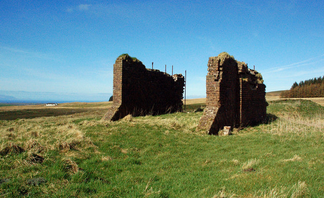
Ruined brick walls stand at the head of the Drumgrange incline, and some of the ground around has been re-graded.
The ruined incline head at Lethanhill.
Related mines
- Bowhill Pits — Shared operator and railway: the Dalmellington Iron Company's plateau line ran from Drumgrange to the Bowhill pits.
- Chalmerston Colliery — Shared operator: both were Dalmellington Iron Company pits on its Doon Valley railway; Chalmerston coal went on using the plateau system after the ironstone pits closed in 1921.
- Waterside Colliery — Shared operator and railway: the Drumgrange incline carried the plateau pits' ironstone down to the Dalmellington Iron Company's works at Waterside.
Nearby mines
- Dunaskin Ironworks — 0.6 miles (1.0 km) SE, South Ayrshire
- Dalmellington Iron Works — 0.7 miles (1.1 km) SE
- Jellieston Colliery — 1.1 miles (1.8 km) NW
- Houldsworth Colliery — 1.7 miles (2.8 km) SW
- Bowhill Pits — 2.0 miles (3.3 km) N
Straight-line distance, within 9 miles (15 km). Show on the map.
Further reading
The hill village at the head of the Drumgrange incline, with the plateau railway and the closure of the ironstone mines.
View sourceSources
- (secondary) Drumgrange Pit No 1 (RAILSCOT) — RAILSCOT
- (secondary) Dalmellington Iron Company Phase 2 (RAILSCOT) — RAILSCOT
- (secondary) Lethanhill (RAILSCOT) — RAILSCOT
- (primary) Drumgrange Colliery (Durham Mining Museum) — Durham Mining Museum
- (secondary) Drumgrange No. 8 Pit (Scottish Cave and Mine Database, site 8322) — Grampian Speleological Group
- (primary) BGS mine plan: CORBY CRAIGS NOS. 1-7, DRUMGRANGE NOS. 6, 7, 9, ESCAPE, LAIGHT, blackband ironstone, abandoned 2 September 1901 — British Geological Survey
Record created: 5 November 2026 · Last researched: 5 November 2026