 MineArchive
Chalmerston Colliery
| Also known as | Chalmerston Mines, Chalmerston Nos. 4 and 5 |
|---|---|
| Location | Chalmerston, near Dalmellington, Doon Valley, East Ayrshire — 55.3429, -4.3992 (approximate) |
| Commodities | Coal, Ironstone |
| Type | Coal |
| Worked | 1860–1959 |
| Operators | Dalmellington Iron Company (1860–1883) — Nos. 1 to 3, served by the company railway (RAILSCOT) Bairds & Dalmellington Ltd (1925–1947, owner) — Owner of Nos. 4 to 7 before nationalisation (DMM c218) National Coal Board (1947–1959) — Nos. 4 and 5 to December 1959 (DMM c218; NMRS) |
A group of Dalmellington Iron Company and later Bairds and Dalmellington pits on the hillside near Dalmellington, worked from about 1860; the last deep mines, Nos. 4 and 5, closed in 1959, and the ground was later dug as a large opencast.
Location
Approximate location. The large pin is this mine; the small round markers are the nearest mines on record. Click one for its page. View on full map
History
The Dalmellington Iron Company opened the first Chalmerston pits near Dalmellington, at the head of the Doon Valley, around 1860. No. 1 Pit worked from about 1860 to 1880 and No. 2 from 1860 to 1883, both served by the company's railway, with No. 3 from 1863 to 1883 at only 12 fathoms. Their plans, for the Hard or Splint, Head and Minnivey coals and the Palace Craig ironstone, were closed in 1883. Colliers were killed by roof falls at Chalmerston in 1865, 1873 and 1874, the last of them sixteen years old.
Mining returned in the twentieth century under Bairds and Dalmellington Ltd. Nos. 4 and 5 opened in 1925 (or 1924 by another account), No. 4 as a drift mine, and Nos. 6 and 7 followed; by one account No. 6 worked from 1925 to 1935 and by another Nos. 6 and 7 together from 1934 to 1952. Nos. 4 and 7 employed 310 in 1937 and 351 in 1940. Under the National Coal Board from 1947, the colliery had 262 men and raised 77,000 tons of gas, household and industrial coal that year; in 1954 Nos. 4 and 5 employed 259 and worked the Chalmerston, High, Splint and Two Feet Seven seams. Nos. 4 and 5 closed in December 1959, and their last plans, covering the Ell, Twenty Inch, High, Chalmerston, Minnivey and Pennyvenie seams, are dated 1960.
In the later twentieth century the Chalmerston opencast spread over hundreds of acres of the hill, and was still working in 1996, by which time it had obliterated most of the older workings on that part of the hill.
Geology
Ayrshire Coal Measures of the Dalmellington field. The early pits worked the Hard or Splint, Head and Minnivey coals and the Palace Craig ironstone; the twentieth-century mines worked the Chalmerston, High, Splint, Two Feet Seven, Ell, Twenty Inch, Minnivey and Pennyvenie seams, with the Low Camlarg abandoned in 1957.
Workings
Shallow nineteenth-century pits, Nos. 1 to 3, the third 12 fathoms deep. In the twentieth century No. 4 was a drift mine, with a fan house, a winding engine house for No. 6 and pithead baths and canteen recorded by Historic Environment Scotland; later an opencast covering hundreds of acres.
Closure
Nos. 6 and 7 closed in 1952 and Nos. 4 and 5 in December 1959. The later opencast had ceased extraction by 2022.
What remains
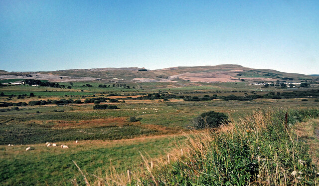
The opencast ground on the upper hill is a largely unrestored black moonscape with new lochs; some re-grading has been done on the lower slopes seen from the valley.
Related mines
- Bogton Colliery — Neighbouring Bairds and Dalmellington mines near Dalmellington, both closed by the NCB in the 1950s; both worked the Ell and Pennyvenie seams.
- Drumgrange Pits — Shared operator: both were Dalmellington Iron Company pits on its Doon Valley railway; Chalmerston coal went on using the plateau system after the ironstone pits closed in 1921.
- Pennyvenie Colliery — Shared operator and railway: both were Dalmellington Iron Company and then Bairds and Dalmellington pits on the company's Doon Valley line.
Nearby mines
- Pennyvenie Colliery — 1.2 miles (2.0 km) SE
- Bogton Colliery — 1.4 miles (2.3 km) S
- Waterside Colliery — 1.8 miles (2.9 km) SW
- Beoch Colliery — 2.0 miles (3.3 km) E
- Benbain Colliery — 2.1 miles (3.4 km) E
Straight-line distance, within 9 miles (15 km). Show on the map.
Further reading
Historic Environment Scotland's record of the Nos. 4 and 5 mines, with survey photographs of the drift entrance, fan house and baths.
View sourceSources
- (secondary) Chalmerston No 1 Pit (RAILSCOT) — RAILSCOT
- (secondary) Chalmerston No 2 Pit (RAILSCOT) — RAILSCOT
- (primary) BGS mine plan: CHALMERSTON, Hard (or Splint), Head, Palace Craig Ironstone and Minnivey, 1883 — British Geological Survey
- (secondary) Dalmellington Area — Northern Mine Research Society
- (secondary) Chalmerston No 4,5 Collieries (RAILSCOT) — RAILSCOT
- (primary) Chalmerston Colliery (Durham Mining Museum) — Durham Mining Museum
- (primary) Dalmellington, Chalmerston Mines (Canmore 42566) — Historic Environment Scotland
- (primary) Dalmellington, Chalmerston Nos. 4 and 5 Mines (Canmore 133186) — Historic Environment Scotland
- (primary) BGS mine plan: CHALMERSTON 4/5/7, Chalmerston seam, 1960 — British Geological Survey
- (observational) Moonscape scenery on the former Chalmerston Colliery (Geograph, Mary and Angus Hogg) — Geograph Britain and Ireland
- (observational) Chalmerston Colliery in action 1996 (Geograph, Mary and Angus Hogg) — Geograph Britain and Ireland
Record created: 5 November 2026 · Last researched: 5 November 2026