 MineArchive
Beoch Colliery
| Also known as | Beoch No. 4 Colliery, Benbain No. 5 Mine |
|---|---|
| Location | The Two Beochs, Dalmellington, East Ayrshire — 55.3539, -4.3509 (approximate) |
| Commodities | Coal, Ironstone |
| Type | Coal |
| Worked | 1837–March 1968 |
| Maximum depth | Unknown. |
| Operators | Dalmellington Iron Company (?–1931), Bairds & Dalmellington Ltd (1931–1947), National Coal Board (1947–1968) |
Overview
A Dalmellington Iron Company colliery on the moorland of the Two Beochs, south-east of Dalmellington, whose No. 3 and No. 4 surface mines were said to be the highest coal workings in Scotland. It is listed from 1837, employed 386 people in 1954 under the National Coal Board, and closed in March 1968.
History
Beoch takes its name from the lands of the Two Beochs, on the high ground south-east of Dalmellington. The minerals there belonged to McAdam Cathcart of Craigengillan. In 1847 the new Nithsdale Iron Works on the Connel Burn, later the New Cumnock Iron Works, leased the ironstone, coal and fireclay and ran a mineral railway some ten kilometres across to its furnaces; an ironstone pit at Beoch was working in 1850. The New Cumnock ironstone proved unfit for purpose and the company failed, and the Dalmellington Iron Company took the leases, chiefly for the coal. The National Mining Register gives the colliery's opening as 1837.
Under Dalmellington, Beoch was a small working for half a century: the Lists of Mines return nine people in 1894 and nineteen in 1910, raising manufacturing coal from the High, Low Pennyvenie and Splint seams. It grew after the First World War, to 310 people in 1923. The No. 3 mine was begun in 1866 by Canmore's account, and the No. 4 in 1937; both were surface mines rather than shafts, and in 1931 they passed with the rest of the company to Bairds and Dalmellington Ltd.
In 1948 the two mines together raised about 500 tons a day, 132,500 tons a year, with 281 people. Their coal went down to Pennyvenie to be screened and on to Dunaskin to be washed, and the men had to go to Pennyvenie for baths. At about 1,100 feet the mines were the highest in Scotland, and in a bad winter the coal track to Pennyvenie No. 4 had to be dug out of the snow by hand. The workforce peaked at 460 in 1960, and both mines closed in March 1968.
Geology
The Dalmellington outlier of the Ayrshire coalfield: the High, Low Pennyvenie, Splint, High Camlarg, Smithy and Lower Smithy coals, the Two Feet and Three Feet, and the High and Low Coking seams, with the Dalmellington Blackband ironstone, which was also quarried near the old ironstone pit.
Workings
An ironstone pit of about 1850 and coal pits on the Two Beochs, followed by the No. 3 (from 1866) and No. 4 (from 1937) surface mines, whose coal was screened at Pennyvenie and washed at Dunaskin.
Closure
Both Beoch mines closed and were abandoned in 1968, the National Mining Register giving March 1968.
What remains
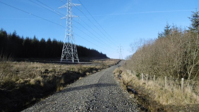
The edge of the No. 4 pithead area lies under a forestry plantation and a new power line.
Redevelopment
Part of the site is now forestry, with an electricity substation and power line nearby.
Related mines
- Benbain Colliery — Neighbouring Dalmellington Iron Company workings: Canmore gives Beoch No. 4 the alternative name Benbain No. 5 Mine, and the two records may overlap.
- Pennyvenie Colliery — Beoch's coal was taken to Pennyvenie for screening, along a track to Pennyvenie No. 4.
Nearby mines
- Benbain Colliery — 0.1 miles (0.1 km) SE
- Pennyvenie Colliery — 1.7 miles (2.8 km) SW
- Waterside Colliery — 3.8 miles (6.2 km) SW
- Dalmellington Iron Works — 4.2 miles (6.8 km) W
- Greenhill Colliery — 4.2 miles (6.8 km) NW
Straight-line distance, within 9 miles (15 km). Show on the map.
Recorded claims
Individual factual claims, each attached to the source(s) that support it below. Where sources disagree, both are kept.
- The National Mining Register lists Beoch, Dalmellington, as opened in 1837 and closed in March 1968. 1
- In 1847 the Nithsdale Iron Works leased the ironstone, coal and fireclay of the Two Beochs; the Dalmellington Iron Works later took the leases, chiefly for the coal, and its pits took the name Beoch. 2
- The colliery's owners were the Dalmellington Iron Company, Bairds and Dalmellington Ltd and, from 1947, the National Coal Board. 3,4
- Beoch employed nine people in 1894, 310 in 1923 and 386 in 1954, when its Nos. 3 and 4 worked the High, Splint and Low seams. 3
- Beoch No. 3 was a surface mine begun in 1866 and closed in 1968, with a peak workforce of 460 in 1960. 4
- Beoch No. 4 was a surface mine begun in 1937 and closed in 1968; in 1948 it raised 330 tons a day with 169 employees. 5
- Beoch was the highest coal mine in Scotland, at about 1,100 feet, and its coal track to Pennyvenie No. 4 had to be cleared of snow by hand in bad winters. 5,4
- Plans survive of Beoch workings abandoned in the Lower Smithy in 1874 and of Beoch No. 4 Mine in the High Camlarg in 1965. 6,7
Photographs & further reading
The Grampian Speleological Group's entry for the Beoch ironstone pit of about 1850, with the history of the Two Beochs leases.
View sourceSources
- (secondary) Dalmellington Area — Northern Mine Research Society
- (secondary) Beoch (Ironstone Pit), Scottish Cave and Mine Database site 10014 — Grampian Speleological Group
- (primary) Beoch Colliery — Durham Mining Museum
- (secondary) Beoch No.3 Colliery (NRHE 133195) — Historic Environment Scotland (trove.scot / Canmore)
- (secondary) Beoch No.4 Colliery (NRHE 80648) — Historic Environment Scotland (trove.scot / Canmore)
- (primary) BEOCH NO 4 MINE, High Camlarg: abandonment plan catalogue entry (1965) — British Geological Survey / Mining Remediation Authority
- (primary) BEOCH, Lower Smithy (Pennyvenie Low): abandonment plan catalogue entry (1874) — British Geological Survey / Mining Remediation Authority
Record created: 4 October 2026 · Last researched: 8 October 2026