 MineArchive
Cwmerfin Mine
| Also known as | Cwm Erfin Mine, Cwmerfyn Mine |
|---|---|
| Location | Cwmerfyn, Trefeurig, about 9 miles east of Aberystwyth, Ceredigion — 52.4276, -3.9207 (exact) |
| Commodities | Lead, Copper, Silver, Zinc |
| Type | Metal |
| Worked | 17th century–1889 |
| Maximum depth | Below the 69-fathom level (more than 126 m under the adit) |
| Operators | John Taylor & Sons (1848–?) — Took the idle mine up between 1848 and 1850, deepened the shafts to the 69-fathom level and reported its sales into the 1870s. Sir Hugh Myddelton — Named with Bushell as working the mine in the first half of the seventeenth century. Thomas Bushell — Bushell's level here was driven about 1638. |
Cwmerfin was a silver-lead mine in the Erfin valley, north of Goginan and east of Aberystwyth, reopened by John Taylor and Sons between 1848 and 1850. It is counted among the mines worked by Sir Hugh Myddelton and Thomas Bushell in the seventeenth century. From 1849 to 1877 it returned 9,919 tons of lead ore and over 180,000 ounces of silver, and it closed for good in 1889.
Location
Recorded location. The large pin is this mine; the small round markers are the nearest mines on record. Click one for its page. View on full map
History
Cwmerfin is usually given a prehistoric origin and a seventeenth-century working under Myddelton and Bushell; Bushell's level, driven about 1638, was built by cut and cover, with dry rubble sides and a roof of slabs. The pedigree is less secure than it sounds. The Cwmerfin listed among the Mines Royal at that time seems, from a contemporary map, to have been a different mine half a mile to the south-east, later called Bwlch, and there is no direct evidence that this one is as old as its neighbours.
It had stood idle since about 1795 when John Taylor and Sons took it up between 1848 and 1850. They deepened two existing shafts, the Engine shaft and the Whim or Drawing shaft, to the 69-fathom level and extended the adit. Later two higher adits, Williams's and Pryse's levels, were driven east of the Drawing shaft, and Taylor's shaft was sunk to the 45-fathom level on the south side of the stream.
The ore came in short bunches that could not be relied on from one level to the next. The best of it lay east of the Drawing shaft on a south branch of the lode, in the adit and the 10 and 20-fathom levels; the 69-fathom level ran more than 100 fathoms east and found almost nothing. Lead ore was returned for the years 1849 to 1877, with small parcels of copper ore and blende beside it. The 1860s gave a good yield of silver. The mine closed in 1889.
Geology
The lode lies mainly on the north slope of the valley, with a south branch 10 to 13 fathoms off that diverges eastward and carried the best ore. Two or more north-south cross-courses shift it about 5 fathoms east of Williams's adit. The ore body was shallow: its base forms a trough from the 45-fathom level at Taylor's shaft down to about 60 fathoms between the Engine and Drawing shafts, nowhere more than 90 fathoms deep, and it follows the basin into which the rocks are folded between two anticlines. Below it, and in the Engine shaft under the 69-fathom level, no ore was found.
Geological setting: Veins and Lodes (well documented example)
Workings
The adit opens near the bridge over the stream, at about 595 feet above sea level. Williams's level is about 30 fathoms above it and Pryse's level about 25 fathoms higher again; Pryse's was wholly barren. The Engine shaft, to the west, and the Whim or Drawing shaft, to the east, reach the 69-fathom level, and the Engine shaft was sunk below it. Taylor's shaft, south of the stream, goes to the 45-fathom level, and 280 yards further west a shallow adit was driven 42 fathoms as a trial.
Closure
The last regular return of lead ore is for 1877; a little blende was returned in 1887 and 1889, and the mine closed in 1889.
What remains
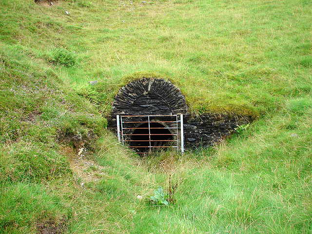
The site has been landscaped and much has been lost. A stone-arched drainage adit, gated, was still open in a grass bank in 2008.
Entrances to levels and shafts, fragments of buildings including ore bins, tips and traces of tramways. Bushell's level, with its rubble walls and slab roof, is the most important survival.
Nearby mines
- Bwlch Mine — 0.5 miles (0.8 km) SE
- Cwmsymlog Mine — 0.7 miles (1.1 km) NE
- Goginan Mine — 0.7 miles (1.1 km) S
- South Darren Mine — 0.7 miles (1.1 km) W
- Gwaith Yr Afon Mine — 0.8 miles (1.2 km) NW
Straight-line distance, within 9 miles (15 km). Show on the map.
People
- Thomas Bushell · proprietor — via the operator record
- Sir Hugh Myddelton (d. 1631) · proprietor — via the operator record
Further reading
The Royal Commission's site record, with aerial photographs from 1992 and 2007.
View sourceSources
- (primary) Cwmerfyn Lead Mine (NPRN 33827) — Coflein, Royal Commission on the Ancient and Historical Monuments of Wales
- (secondary) Cwmerfyn — Wikipedia
- (primary) Lead and Zinc: The Mining District of North Cardiganshire and West Montgomeryshire (Special Reports on the Mineral Resources of Great Britain, vol. XX), O. T. Jones, 1922 — Memoirs of the Geological Survey
- (observational) Mine drainage adit in Cwmerfyn (Geograph photograph 928336, 2008) — Geograph
- (primary) Mine plan: Cwmerfin Mine, SN68SE 3, location of mine, notes and letters 1871 (KP16930) — British Geological Survey
Record created: 18 November 2026 · Last researched: 18 November 2026