 MineArchive
Castell Mine
| Also known as | West Esgairlle Mine, Dyffryn Castell Mine, New Castell Mine, Nant y Meirch Mine, Gwaith Du |
|---|---|
| Location | Dyffryn Castell, east of Ponterwyd, Ceredigion — 52.4160, -3.8025 (exact) |
| Commodities | Lead, Zinc, Copper |
| Type | Metal |
| Worked | c. 1785–1917 (last output) |
| Maximum depth | 27 fathoms (about 49 m) |
| Operators | Thomas Bonsall (1785–?) — Credited with opening the mine for blende in 1785. Job Sheldon & Co. (1802–?, lessee) — Lease from Lord Powys about 1802; working the mine in 1815. West Esgairlle Mining Co. Ltd (1873–1876) — New waterwheel, crusher and dressing mill erected under Captain Roach in June 1873; insolvent 1876. New Castell Mines Ltd (1898–1908) — Took over in 1897 and re-erected the plant in spring 1898; sold 3,037 tons of blende between 1899 and 1908. New Castell Blende Mine Ltd (1912–?) — Sold blende in 1912-14 and 1916-17; still paying wages in 1918 and remembered as lasting until about 1922. |
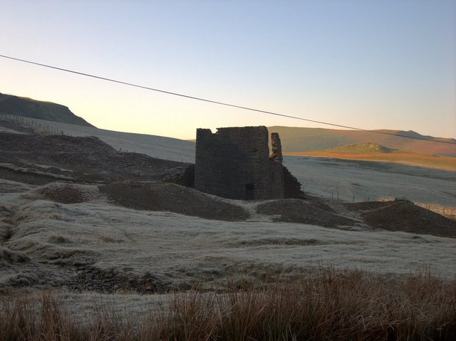
Castell is a shallow zinc mine beside the Aberystwyth to Llangurig road at Dyffryn Castell, east of Ponterwyd, opened for blende in the 1780s. It was worked on and off under half a dozen names until about 1922 and sold more than 5,000 tons of zinc ore, with very little lead. Its roofless crusher house of 1898 and the wheelpit beside it are a scheduled monument.
Location
Recorded location. The large pin is this mine; the small round markers are the nearest mines on record. Click one for its page. View on full map
History
Castell was a zinc mine from the start. It is generally said to have been opened for blende by Thomas Bonsall in 1785; another account has James Lowe of Dol-y-gors opening it a few years earlier, between 1770 and 1780, for the Earl of Powys, who held it from the Crown. About 1802 Job Sheldon and Company took a lease from Lord Powys, and they were working it in 1815. In those years it went by the name of Nant y Meirch, after the stream that runs through it. It would collect several more names before it was done.
Very little was done between about 1825 and 1850. The mine then reappeared as West Esgairlle, had a 30-foot waterwheel for crushing by 1856, and was put up for sale in November of that year. A London company is said to have worked it until 1868 with about 60 people. In June 1873 the West Esgairlle Mining Company refitted it with a new waterwheel, crusher and dressing mill, and went under in 1876. Others kept the mine going until 1890; 1882 was the best year, with 390 tons of zinc ore sold for £1,170 by 26 miners and 12 dressers.
The longest spell of work began in 1897, when New Castell Mines Ltd took over from a short-lived partnership. Captain John Owen re-erected the plant in the spring of 1898 and built the crusher house that still stands. Under Henry Francis the company lived entirely on blende, selling 3,037 tons between 1899 and 1908. Owen bought the mine himself in 1910 and died the next year.
His executors sold to the New Castell Blende Mine Ltd in 1912, which sold 70 tons that year and 166 the next, stopped in 1914 and came back for the wartime zinc prices of 1916 and 1917. The company was still paying wages in 1918 and is remembered as lasting until about 1922. In all, blende was returned in 39 years between 1857 and 1917, to a total of 5,365 tons.
Geology
The mine works the Castell lode, a belt of brecciated rock 10 to 15 fathoms wide in places, with the lower beds of the Frongoch formation on its south side and the Gwestyn shales on the north. The ore is overwhelmingly blende, with calcite and quartz, and lay within about 110 to 120 fathoms of the Engine shaft, mainly in the flanks and bottom of a syncline and where the lode swerves. A narrow lode south of the main one carries galena. At the shaft half a mile to the east the ore was copper.
Geological setting: Veins and Lodes (well documented example)
Workings
A large body of blende was taken out from the surface down to the 20-fathom level in a wide opencast east of the Engine shaft. The shaft is about 27 fathoms deep, and an adit cross-cut drains the mine to about 7 fathoms below the surface. The 10 and 20-fathom levels were driven nearly 80 fathoms east and about 50 west, with cross-cuts north and south to test the width of the lode. A subsidiary shaft, East Castell or West Esgairlle, was sunk in 1874 about 0.6 km to the east. Waterwheels did the crushing and pumping, fed by four leats: one from a reservoir to the south and three parallel channels about 2.5 km long from weirs on the Afon Castell.
Closure
Production stopped in 1914 and picked up again, on a small scale, in 1916 and 1917, the last years for which ore was returned. The New Castell Blende Mine Ltd is remembered as working until about 1922 before it was wound up.
What remains
The main site is a scheduled monument, designated on 29 August 1993. The shell of the crusher house stands beside the road; the Engine shaft is covered with a steel grille. The building at the eastern shaft has been adapted for farm use.
The crusher house of 1898, of coursed rubble with iron lintels, with a well-preserved wheelpit 43 feet by 5 alongside. Behind it is the site of the earlier wheel, and above that an engine pit with the foundation of its balance pit and the open shaft. Opencut workings lie to the south-east, and the four leats can be traced. At the eastern site are a capped shaft and a wheelpit 35 feet by 5. The commemorative slate tablet from the wheelpit was found in 1988 laid face down as a kitchen flagstone in Ponterwyd.
Related mines
- Esgairlle Mine — Castell was first known as West Esgairlle, and the Castell lode crosses the hill just beyond the end of Old Esgairlle's middle adit.
- Nant y Creiau Mine — Both were Crown mines held under the Earl of Powys and let to Job Sheldon and Company in the early 1800s, and Captain John Owen worked both after 1900.
Nearby mines
- Brynglas Mine — 1.0 miles (1.6 km) W
- Nant y Creiau Mine — 1.2 miles (1.9 km) SE
- Esgairlle Mine — 1.3 miles (2.1 km) NE
- Temple Mine — 2.1 miles (3.3 km) SW
- Mynach Vale Mine — 2.4 miles (3.8 km) S
Straight-line distance, within 9 miles (15 km). Show on the map.
Further reading
Simon Hughes's history of the two mines, with plans, from Lewis Morris in the 1740s to the last working.
View sourceThe Royal Commission's site record, with an account of the crusher house, the wheelpits and the four leats.
View sourceCadw's description of the scheduled remains and the reason for designation.
View sourceSources
- (primary) Castell Mine (NPRN 33822) — Coflein, Royal Commission on the Ancient and Historical Monuments of Wales
- (primary) Scheduled Monument CD153: Castell Lead Mine — Cadw
- (secondary) The Castell and Nant y Creiau Mines, by S. J. S. Hughes (British Mining No. 43, 1991, pp. 96-117) — Northern Mine Research Society
- (primary) Lead and Zinc: The Mining District of North Cardiganshire and West Montgomeryshire (Special Reports on the Mineral Resources of Great Britain, vol. XX), O. T. Jones, 1922 — Memoirs of the Geological Survey
- (primary) Mine plan: Castell (West Castell, Dyfryn Castell, New Castell) Mine, SN78SE 6 (KP16993) — British Geological Survey
Record created: 18 November 2026 · Last researched: 18 November 2026