 MineArchive
Cae Coch Sulphur Mine
| Location | Above Trefriw, Conwy valley, Conwy — 53.1749, -3.8330 (approximate) |
|---|---|
| Commodity | Pyrite |
| Type | Metal |
| Worked | 1607–1942 |
| Maximum depth | No shaft was sunk. The deposit was worked from four adits driven into the hillside, Nos. 3 and 4 to drain the workings at depth. |
| Operators | Thompson & Hill (1820–1880), William Veitch (1880–1895) |
Overview
Cae Coch, in the hills above Trefriw, is the only sulphur (pyrites) mine of its kind in Wales — first recorded in 1607, and at its wartime peak in 1918 responsible for over half of all the pyrites mined anywhere in the UK.
History
The earliest reference to Cae Coch comes from a 1607 letter by Sir John Wynn, describing ‘great store of brimstone [sulphur]’ at the site, though a later account by Robert Owen records the workings standing idle for twenty-five years before a new company investigated the prospect in 1817. With the growth of alkali manufacturing after 1820, the Liverpool chemical firm Thompson & Hill acquired the mine, shipping its first 100 tons of pyrites in June 1821; output grew slowly, from around 20 tons a month through the 1820s to 80 tons a month by the 1840s, and passed 30,000 tons cumulatively between 1851 and 1878. The Scottish chemical manufacturer William Veitch leased the mine from March 1880, building an incline down to the turnpike road and pushing production to a peak of 9,443 tons in 1885 from a workforce of 119; by his departure in 1895 Veitch had extracted 81,634 tons in total. The North Wales Sulphur Mining Company bought the mine in 1889 but abandoned it within five years. Its most intensive phase came during the First World War, when the government requisitioned it under the Defence of the Realm Act in 1917: a workforce of 230 built a power plant, compressors, a crushing mill and an aerial ropeway across the Conwy valley to the railway, and between May and December 1918 the mine produced 15,951 tons of pyrites — just over half the total pyrites output of the entire United Kingdom that year. A further attempt by the British (Non-Ferrous) Mining Corporation, working under the Ministry of Supply from August 1941, foundered on inconsistent ore thickness and sulphur content, and the mine finally closed on 14 May 1942; later exploration licences granted to John Taylor & Son in 1957 and British Titan Products in 1966 came to nothing.
Geology
The pyrites forms a single massive bed up to 2.2m thick, extending for around 200m, sandwiched between the Ordovician Dolgarrog Volcanic Formation below and the Llanrhychwyn Mudstones above; pure pyrite is 53.4% sulphur by weight, but Cae Coch's ore typically ran at 30-40%. The site is internationally significant to geologists because the pyrite's post-mining oxidation is largely bacteriogenic — driven by bacteria rather than simple chemical weathering. How the bed came to be there is genuinely unsettled. The Geological Conservation Review records that it has been read in turn as an altered ooidal ironstone, as an epigenetic fracture-fill and as a kuroko-type volcanogenic exhalative deposit, before the most recent work classed it as a syn-diagenetic inhalative body: bacterial sulphate reduction in anoxic muds generated hydrogen sulphide, and iron-rich solutions expelled upwards from the underlying Dolgarrog Volcanic Formation reacted with it to pyritise the sediment from within five metres of the sea floor. Sulphur isotope ratios of −20 to −24‰ and a cobalt-to-nickel ratio below 0.5 are the evidence against a volcanogenic origin — both are sedimentary signatures. The ore is mostly a "rubbly" type in the lower part of the bed, becoming laminated upwards, and in the top half-metre there are hollow pyrite tubes 5–10 mm across filled with radiating quartz, which have been read as fossilised black smokers.
Geological setting: Hydrothermal Deposits (historical documentary reference), Sedimentary Beds and Seams (well documented example)
Workings
Ore was worked by the pillar-and-stall method, leaving pillars 2-3 yards square spaced 8-10 yards apart, with timber props added where the roof was weak. Four adits served the site: No.1 reached the upper, northern ore body; No.2 gave the main access into the extensive pillar-and-stall workings; Nos.3 and 4 served as drainage adits.
Closure
The mine closed on 14 May 1942 after the British (Non-Ferrous) Mining Corporation, working under the Ministry of Supply from August 1941, found the thickness and sulphur content of the pyrites too inconsistent to be worth continuing with. It had already stopped once before, in January 1919, when the wartime demand that had made it briefly the largest pyrites producer in the country ended with the Armistice. Exploration licences granted to John Taylor & Son in 1957 and to British Titan Products in 1966 came to nothing.
What remains
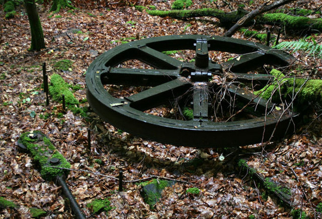
The mine remains open and unfenced on Forestry Commission land. No.2 adit, around 30ft high, opens directly into workings scarred by numerous roof falls, some recent; the lower levels are flooded to adit level. Vivid iron- and sulphur-stained pools and calcite formations survive underground, along with remnants of the WWI aerial ropeway's sheave wheel and other surface infrastructure. The mine is internationally known for what has grown in it since: an acidophilic microbial ecosystem of autotrophic and heterotrophic bacteria, moulds, yeasts, rotifers and protozoans, forming gelatinous stalactite-like growths on wet surfaces and "acid streamers" up to half a metre thick in the drainage. More than 100 cubic metres of this biomass is estimated to be present. The streamers disappear once the drainage reaches daylight.
A good deal survives above ground. The sheave wheel for the top of the 1917 aerial ropeway is still in place in a gully beside the footpath, with the footings of a small building opposite. The linear quarry that follows the outcrop of the northern ore body, the earliest working on the site, is still open with No. 1 adit visible at its foot, badly silted. Elsewhere on the hillside are the inclines, the drum house, storage bins, the foundations of the processing mill and other buildings, and the blocked Nos. 3 and 4 drainage adits.
Nearby mines
- Hafna Mine — 3.5 miles (5.6 km) S
- Parc Mine — 3.5 miles (5.7 km) S
- Pandora Mine — 3.6 miles (5.8 km) S
- Cedryn Quarry — 3.8 miles (6.1 km) SW
- Cwm Eigiau Quarry — 4.9 miles (7.8 km) W, Gwynedd
Straight-line distance, within 9 miles (15 km). Show on the map.
What's uncertain
Points where sources disagree or the record could not be settled; both accounts are kept. All open questions in the archive.
- A June 2018 report describes vividly coloured mineral deposits and acidic pools in the upper levels, comparing the interior to 'being inside a volcano', while noting the sulphur smell was much fainter than expected and that the mine has two natural exits allowing air to circulate. (uncertain) 3
- The Geological Conservation Review records the Cae Coch massive stratabound pyrite deposit as of controversial origin, variously interpreted as an altered ooidal ironstone, an epigenetic fracture-fill and a kuroko-type volcanogenic exhalative deposit, with the most recent examination classing it as a syn-diagenetic inhalative body formed by bacterial sulphate reduction in anoxic muds. (disputed) 2
Recorded claims
Individual factual claims, each attached to the source(s) that support it below. Where sources disagree, both are kept.
- William Veitch's 1880-95 lease at Cae Coch produced a peak of 9,443 tons of pyrites in 1885 from a workforce of 119, extracting 81,634 tons in total before his departure in 1895. 1
- Between May and December 1918, under wartime government control, Cae Coch produced 15,951 tons of pyrites — just over half the total pyrites output of the entire United Kingdom that year. 1
- Cae Coch is internationally significant to geologists because the post-mining oxidation of its pyrite deposit is largely driven by bacteria rather than simple chemical weathering. 2
- A final attempt to work Cae Coch by the British (Non-Ferrous) Mining Corporation from August 1941 foundered on inconsistent ore thickness and sulphur content, and the mine closed for good on 14 May 1942. 1
- A June 2018 report describes vividly coloured mineral deposits and acidic pools in the upper levels, comparing the interior to 'being inside a volcano', while noting the sulphur smell was much fainter than expected and that the mine has two natural exits allowing air to circulate. (uncertain) 3
- The Geological Conservation Review records the Cae Coch massive stratabound pyrite deposit as of controversial origin, variously interpreted as an altered ooidal ironstone, an epigenetic fracture-fill and a kuroko-type volcanogenic exhalative deposit, with the most recent examination classing it as a syn-diagenetic inhalative body formed by bacterial sulphate reduction in anoxic muds. (disputed) 2
- More than 100 cubic metres of microbial biomass is estimated to be present in the workings, in gelatinous stalactite-like growths and acid-streamers up to 0.5 m thick; the streamers disappear once the mine drainage reaches the surface. 2
Photographs & further reading
An underground report on the upper levels, mineral-stained pools and acidic environment.
View sourceSources
- (secondary) Cae Coch Sulphur Mine — Subterranea Britannica
- (primary) Cae Coch Mine — GeoGuide, Scottish Geology Trust
- (observational) Cae Coch Sulphur mine, Llanrwst — June 2018 — 28DaysLater
- (primary) BGS mine plans catalogue: CAE COCH — British Geological Survey
Record created: 20 August 2026 · Last researched: 6 September 2026