 MineArchive
Burtersett Flag Stone Mine
| Also known as | Burtersett Quarries, Burtersett (Slate and Stone) |
|---|---|
| Location | Burtersett, near Hawes, North Yorkshire — 54.2919, -2.1664 (approximate) |
| Commodities | Flagstone, Sandstone |
| Type | Stone |
| Worked | From 1882–1929 |
| Maximum depth | Not applicable: levels driven into the hillside, not a shaft. |
| Operators | Richard Metcalf (1882–1900), Storth Colliery Company (1920–1929) |
Overview
A Wensleydale stone mine above Burtersett near Hawes, driven into the hillside to win flagstone from a sandstone bed between limestones. It employed fifty-four people in 1896, thirty-four of them underground, and the returns follow the trade's own vocabulary as they go: flag stone in the 1880s, slate and stone in the 1890s, plain sandstone from 1902. The Metcalfs held it for its best years.
History
Burtersett stands above Hawes at the head of Wensleydale, and its quarries were worked for the flagstone that roofs and floors half the dale. The 1881 Mines Inspectors Report and the Lists of Mines from 1882 give Richard Metcalf as owner in the 1880s and R. M. Metcalfe in the 1890s — the same family under two spellings — followed by J. B. Johnson in the 1910s and the Storth Colliery Co. in the 1920s.
The workforce peaked at fifty-four in 1896, thirty-four of them below ground, having been thirty-nine in 1883 and forty-seven in 1894. After 1900 it falls steadily: thirty-eight in 1900, twenty-four in 1905, nine in 1910. The product name changes with it. The returns say flag stone from 1882 to 1890, slate and stone in 1894 and 1896, slate in 1900, and sandstone from 1902 to 1929 — not because the rock changed but because the trade's names for it did, and because the flag and roofing trade gave way to plain building stone.
The 1888 List of Mines under the Metalliferous Mines Act gives it simply as 'Burtersett, Hawes, R. Metcalf, Richard Metcalf, Burtersett, near Hawes, R.S.O. (Yorks)' — the owner living in the village his mine employed.
Geology
The stone is Yoredale sandstone, laid down between limestones in the rhythmic Carboniferous sequence that gives Wensleydale its stepped hillsides. That layering is what made the working a mine rather than a quarry: the sandstone sits as a bed within the sequence, so on a hillside it was easier to burrow in from the side and follow the bed than to strip everything above it. Where the rock splits cleanly it was worked for flags and roofing slates — not true slate, which is metamorphic, but sandstone that parts along its bedding — with the poorer material going for general building.
Geological setting: Sedimentary Beds and Seams (well documented example)
Workings
Levels driven into the hillside above the village, following the workable bed, with dressing floors outside the entrances where the stone was split and squared. The returns show the working consistently divided between underground and surface hands — twenty-nine below and eighteen above in 1894, thirty-four and twenty in 1896 — the surface men doing the splitting and dressing. Waste tips run below the levels down the slope towards Burtersett.
Closure
Sandstone was still being returned in 1929, by which time the working was very small; the closing date is not known.
What remains
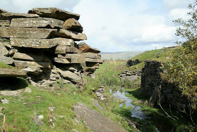
The old quarries survive above the village as a landscape of levels, dressing floors and waste tips: stacked slabs of flagstone still lie at the mouth of one of the levels beside the beck, with ruined walling of the dressing floor opposite and the moor rising behind. A caving and mine-exploration party that went through in July 2022 described the Pennine sandstone workings as partly underground precisely because of the way the rock is bedded, and Burtersett as one of several such mines at the head of Wensleydale.
Level mouths, dressing floors, stacked worked flags and waste tips on the hillside above Burtersett.
Redevelopment
Unknown.
Nearby mines
- Stags Fell Quarries — 2.7 miles (4.4 km) NW
- Beezy Mine — 4.9 miles (7.9 km) NE
- Lover Gill Mine — 4.9 miles (7.9 km) N
- Crackpot Moor Mine — 5.6 miles (9.0 km) N
- Stockdale Colliery — 6.1 miles (9.9 km) N
Straight-line distance, within 9 miles (15 km). Show on the map.
Recorded claims
Individual factual claims, each attached to the source(s) that support it below. Where sources disagree, both are kept.
- The 1888 List of Mines gives 'Burtersett, Hawes, R. Metcalf, Richard Metcalf, Burtersett, near Hawes'; the Durham Mining Museum adds R. M. Metcalfe in the 1890s, J. B. Johnson in the 1910s and the Storth Colliery Co. in the 1920s. 1,2
- Thirty-nine were employed in 1883, forty-seven in 1894 and fifty-four in 1896, thirty-four of them below ground; the figure fell to nine by 1910. 1
- The returns describe the output as flag stone from 1882 to 1890, slate and stone in 1894 and 1896, slate in 1900, and sandstone from 1902 to 1929. 1
- Pennine sandstone of this kind was deposited between layers of limestone, so on a hillside it was easier to burrow in from the side than to dig down from above; the splittable beds were worked for flags and roofing slates and the poorer stone for general building. 3
Photographs & further reading
A visit through the Burtersett workings explaining why the Wensleydale sandstone was mined from the side rather than quarried from above, with photographs underground.
View sourceOwners, output and employment returns from 1882 to 1929, with the underground and surface split, drawn from the 1881 Mines Inspectors Report and the Lists of Mines.
View sourceSources
- (primary) Burtersett (Slate and Stone) — Durham Mining Museum
- (primary) 1888 List of Mines under the Metalliferous Mines Act: Flag Stone Mines — Mines Department, via the Durham Mining Museum
- (observational) Pennine Sandstone Mines 1, Burtersett, Yorkshire (visit report, July 2022) — 28DaysLater
Record created: 4 September 2026 · Last researched: 4 September 2026