 MineArchive
Abergorki Colliery
| Also known as | Abergorky Colliery, Abergorki Level |
|---|---|
| Location | Cwm Orci, above Treorchy, Rhondda Fawr, Rhondda Cynon Taf — 51.6620, -3.5090 (approximate) |
| Commodity | Coal |
| Type | Coal |
| Worked | 1859–1938 |
| Maximum depth | Unknown. Opened as a level. |
| Operators | Haughty Huxham (1859–1862), Burnyeat, Brown and Company (1874–1900) |
Overview
Abergorki was opened as a level in Cwm Orci, north of Treorchy in the Rhondda Fawr, in 1859 by Haughty Huxham, a former manager of the Bute Merthyr Colliery, and sold to J. H. Insole of Cymmer in 1862. It was the principal cause of Treorchy’s growth: the town was built entirely on Bute estate land from the 1850s, laid out with the spacious streets the estate insisted on after the Public Health Act of 1848, and the colliery had its own outlying settlement of isolated rows. The official list of collieries at work in 1880 returns two Abergorki collieries in the Pontypridd district, one under Burnyeat Brown and Co. and one under the Coffin Co. It closed in 1938, and the Abergorki Workmen’s Institute and Abergorki Hall keep the name in the town.
History
The Rhondda Fawr above Ystrad was demesne land of the medieval Lordship of Glynrhondda and, by the nineteenth century, Bute estate property. Treorchy itself was established entirely on that land from the 1850s, on the farms of Tyr Gibbon, Ystrad Fechan, Tyr y Felin, Glyn Coli, Tile Du and Abergorchwy, and the spacious layout of its streets reflects the control the estate exerted over planning after the Public Health Act of 1848.
The principal cause of the town’s growth was Abergorki Colliery, in Cwm Orci to the north. The Glamorgan-Gwent Archaeological Trust’s historic landscape characterisation records it as opened as a level in 1859 by Haughty Huxham, a former manager of the Bute Merthyr Colliery, and sold to J. H. Insole of Cymmer in 1862. By the survey of the first edition six-inch Ordnance map in 1875 a linear grid of streets was emerging either side of the main thoroughfare, the long terraces of two-storey cottages along High Street largely built, a church and at least four nonconformist chapels in place, and the Parc & Dare band room established in Luton Street.
The colliery was among the largest in the valley. The official list of collieries at work in 1880 carries two Abergorki entries in the Pontypridd district, under Burnyeat Brown and Co. and under the Coffin Co., and a third Abergorki in the Aberdare district — a different mine altogether. Treorchy’s other pits were Tyle-coch, sunk in 1854 by the Newcastle firm of John Carr, Morrison and Company and closed in 1895; Ty’n-y-bedw, sunk in 1876 by Edmund Thomas and George Griffiths and closed in 1933; and, just outside the town, the Parc and Dare collieries sunk in 1865 and 1870 by David Davies and Company, which became the Ocean Coal Company and were amalgamated as Park and Dare in 1955. Abergorki closed in 1938.
Geology
The steam coals of the Rhondda Fawr, in the upper part of the South Wales coalfield. The seams here outcrop high on the valley sides, which is why Abergorki began as a level driven into Cwm Orci rather than as a shaft, and why the deeper Parc and Dare pits nearby had to sink 558 to 1,528 feet to reach the Six Feet, Garw and Upper New seams that lay beneath the same ground.
Geological setting: Sedimentary Beds and Seams (well documented example)
Workings
A level at first, driven into Cwm Orci in 1859, and later a colliery of a scale to employ thousands. The 1896 inspectors’ list records both a colliery and a separate Abergorki level under the same ownership, the latter employing fourteen men — the original working still going alongside the pit that had grown out of it. Its surface structures were largely dismantled after closure; engine houses and spoil tips remain absorbed into the landscape above the town.
Closure
Abergorki closed in 1938, before nationalisation and before the wave of Rhondda closures that followed it. Ty’n-y-bedw had gone in 1933 and Tyle-coch as early as 1895; of Treorchy’s pits only Parc and Dare survived the war, amalgamated in 1955 and closed in 1966.
What remains
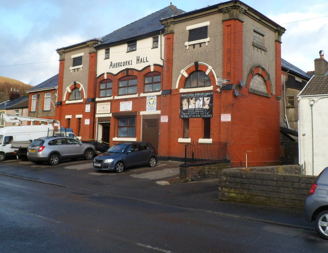
The colliery site is absorbed into the landscape above Treorchy, its surface buildings dismantled and its spoil tips grassed. The name survives in the town below: Abergorki Hall on the main street, inscribed with the year 1915, and the Abergorki Workmen’s Institute.
Abergorki Hall and the Abergorki Workmen’s Institute in Treorchy, and the colliery’s outlying settlement of isolated rows. Engine houses and spoil tips remain in the landscape above the town in altered form.
Related mines
- Tylecoch Colliery — United National Collieries reopened Tylecoch in 1917 and worked it together with the Abergorky pits and level.
Nearby mines
- Tylecoch Colliery — 0.2 miles (0.4 km) SW
- Dare Colliery — 0.7 miles (1.2 km) SW
- Tynybedw Colliery — 0.7 miles (1.2 km) SE
- Ynysfeio Colliery — 0.9 miles (1.5 km) NW
- Pentre Colliery — 1.0 miles (1.7 km) SE
Straight-line distance, within 9 miles (15 km). Show on the map.
Recorded claims
Individual factual claims, each attached to the source(s) that support it below. Where sources disagree, both are kept.
- The official list of collieries at work in 1880 carries two Abergorki entries in the Pontypridd district, "Abergorki, Pontypridd, Burnyeat Brown, and Co." and "Abergorki, Pontypridd, Coffin Co.", and a third, "Abergorki, Aberdare, Aberdare and Plymouth Co.", which is a different mine in another valley. 1
- The Glamorgan-Gwent Archaeological Trust’s historic landscape characterisation records Abergorki as opened as a level in 1859 by Haughty Huxham, a former manager of the Bute Merthyr Colliery, and sold to J. H. Insole of Cymmer in 1862, closing in 1938. 2
- The principal cause of Treorchy’s growth was Abergorki Colliery in Cwm Orci; the town was established entirely on Bute estate land from the 1850s, its spacious street layout reflecting the control the estate exerted over planning after the Public Health Act of 1848. 2
- Tyle-coch Colliery was sunk in 1854 by John Carr, Morrison and Company of Newcastle and closed in 1895; Ty’n-y-bedw was sunk in 1876 by Edmund Thomas and George Griffiths and closed in 1933; the Parc and Dare collieries were sunk in 1865 and 1870 by David Davies and Company and closed in 1966. 2,3
- The Abergorky colliery at Mountain Ash in the Aberdare valley is a separate and much smaller mine — 39 men underground in 1884, sunk 598 ft 8 in, working the Abergorky (Graig) and Gorllwyn seams — later part of the Llewellyn (Nixon) group and then Powell Duffryn. 4
Photographs & further reading
The archaeological characterisation of Treorchy for Cadw, which sets the colliery in the town it created: the Bute estate’s planning control, the 1875 street layout, the chapels and institutes, and the dates of every pit in the neighbourhood.
View sourceSources
- (secondary) List of coal mines UK 1880 — Coalmining History Resource Centre
- (primary) Treorchy — Rhondda Historic Landscape Characterisation (HLCA 011) — Glamorgan-Gwent Archaeological Trust, for Cadw
- (secondary) Dare Colliery, Cwmparc — Welsh Coal Mines
- (secondary) Abergorky, Mountain Ash — Welsh Coal Mines
- (observational) Abergorki Hall, Treorchy (photographed 2012) — Jaggery, Geograph Britain and Ireland
Record created: 6 September 2026 · Last researched: 6 September 2026