 MineArchive
Ystrad Iron Mine
| Also known as | Silurian Iron Mine, Betws Garmon Iron Mine, Ystrad Isaf Mine |
|---|---|
| Location | Western flank of Moel Eilio, above Betws Garmon, Gwyrfai valley, Gwynedd — 53.0938, -4.1817 (approximate) |
| Commodity | Iron |
| Type | Iron |
| Worked | 1909 (small opencasts before 1900)–1919 |
| Maximum depth | Unknown. |
| Operators | Bettws Garmon Iron Ore and Smelting Company Ltd (1909–1913), Silurian Iron Ore Company (1913–1919) |
Overview
The lower of two iron mines on the western flank of Moel Eilio above Betws Garmon, a line of eight opencuts and chambers worked on a large scale only from 1909 until it closed in 1919-20.
History
Ystrad mine, also called the Silurian or Betws Garmon iron mine, lies on the western flank of Moel Eilio above Betws Garmon in the Gwyrfai valley. It is the lower of two iron workings on the same hillside, divided by a parish boundary wall from the Garreg Fawr mine above. Until about 1900 there were only small opencast workings here; one account dates working from about 1880.
In November 1909 the Welsh Coast Pioneer reported that a wealthy company had secured rights over 300 acres of the Ystrad estate, the property of the late Rev. John Parry, vicar of Betws Garmon, and that a large number of labourers were already clearing the surface ahead of the miners. The company was the Bettws Garmon Iron Ore and Smelting Company Ltd, with offices at 1 Queen Victoria Street in London and a local manager from Garndolbenmaen; it meant to send the ore to England at first but hoped to build smelting works on the spot. It was later renamed the Phosphoric Iron Ore Company, and in 1913 the Silurian Iron Ore Company took over its assets, but not its liabilities. A tramway linked the mine to the North Wales Narrow Gauge Railway.
During the First World War the mine was the subject of a labour dispute. In November 1917 Ellis Davies asked in the House of Commons why the Silurian Iron Ore Company of Bangor, after a government arbitrator had awarded its men a rise, had paid them off for want of railway wagons and then offered to take back only some of them; the reply was that one of the company's two works had been stopped for lack of a market, and that the Chief Industrial Commissioner was trying to bring the two sides together. The mine closed in 1919, and the abandonment plan is dated 1920.
Geology
The ore occurs as nodules within mudstones of the Nant Ffrancon formation, in a bed dipping steeply into the hillside.
Workings
Eight galleries or chambers, each about 50 m long, cut along the dip of the ore from opencuts at the surface, with pillars left to hold up the roofs; a drainage adit at the lowest level; a drumhouse, an incline and a dressing floor below.
Closure
Closed in 1919 after a wartime dispute and loss of markets; the abandonment plan is dated 1920.
What remains
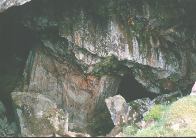
The worked-out chambers form a long diagonal gash up the hillside, open to the surface in places; the lower levels are flooded and the drainage adit is blocked.
A line of eight opencuts and stoped chambers with their waste runs, a drumhouse, the main incline, and a working floor with concrete machine bases, washing channels and a round stone grinding wheel.
Redevelopment
None; open hillside.
Related mines
- Garreg Fawr Iron Mine — Two iron mines on the same hillside of Moel Eilio, divided by a parish boundary wall.
Nearby mines
- Garreg Fawr Iron Mine — 0.3 miles (0.5 km) NE
- Garreg Fawr Slate Quarry — 0.5 miles (0.8 km) N
- Hafod-y-Wern Slate Quarry — 0.7 miles (1.1 km) W
- Alexandra Quarry — 1.6 miles (2.6 km) SW
- Moel Tryfan Quarry — 1.9 miles (3.0 km) SW
Straight-line distance, within 9 miles (15 km). Show on the map.
What's uncertain
Points where sources disagree or the record could not be settled; both accounts are kept. All open questions in the archive.
- The Betws Garmon, Ystrad or Silurian iron mine operated from around 1880 till the 1910s. (uncertain) 2
- The iron ore occurred as nodules within mudstones of the Nant Ffrancon formation. (uncertain) 5,2
Recorded claims
Individual factual claims, each attached to the source(s) that support it below. Where sources disagree, both are kept.
- Until about 1900 the Ystrad mine consisted only of small opencast workings. 1
- The Betws Garmon, Ystrad or Silurian iron mine operated from around 1880 till the 1910s. (uncertain) 2
- In November 1909 the Bettws Garmon Iron Ore and Smelting Company had secured rights over 300 acres of the Ystrad estate at Betws Garmon and had labourers clearing the surface for mining. 1,3
- The Bettws Garmon company was renamed the Phosphoric Iron Ore Company, and in 1913 the Silurian Iron Ore Company took over its assets but not its liabilities. 1
- In 1917 the Silurian Iron Ore Company paid off its men after an arbitrator awarded them a wage rise, citing a lack of railway wagons, and later offered to take back only some of them. 4
- The mine was worked along eight galleries, each about 50 m long, following the dip of the ore. 5,6,7
- The iron ore occurred as nodules within mudstones of the Nant Ffrancon formation. (uncertain) 5,2
- The mine closed in 1919. 1,6
- The abandonment plan of the Ystrad iron mine is dated 1920. 8
Sources
- (observational) Garreg Fawr / Ystrad (Silurian) Iron Mines — GeoTopoi (Graham Stephen)
- (observational) Betws Garmon Iron Mine (Geograph 251739) — Geograph Britain and Ireland
- (primary) The Welsh Coast Pioneer and Review for North Cambria, 18 November 1909: Diwydiant Newydd i Arfon — The Welsh Coast Pioneer and Review for North Cambria (Welsh Newspapers Online, National Library of Wales)
- (primary) Y Genedl, 20 November 1917: Gwaith Haiarn Cymreig: yr anghydfod llafur — Y Genedl (Welsh Newspapers Online, National Library of Wales)
- (observational) Ystrad/ Garreg Fawr Iron Mines — Treasure Maps (Iain Robinson)
- (secondary) Ystrad — Buddlepit Mine Database
- (observational) Betws Garmon Mine — UCET (Underground Cornwall Exploration Team) forum
- (primary) BGS mine plans: YSTRAD IRON MINE (abandoned 1920) — British Geological Survey / Mining Remediation Authority
Record created: 19 October 2026 · Last researched: 20 October 2026