 MineArchive
Garreg Fawr Slate Quarry
| Also known as | Garreg-Fawr Slate Quarry, Garreg Fawr Quarry |
|---|---|
| Location | South-east of Waunfawr, between Betws Garmon and Salem, Gwynedd — 53.1007, -4.1853 (exact) |
| Commodity | Slate |
| Type | Slate |
| Worked | c. 1802–1930s |
| Maximum depth | Unknown. |
Overview
A small slate quarry south-east of Waunfawr, begun about 1802 and worked on and off for more than a century, best known for the castellated slate tower at the head of its incline.
History
Garreg Fawr slate quarry lies on enclosed land south-east of Waunfawr, between Betws Garmon and Salem in the Gwyrfai valley. It began as a small pit about 1802, one of the earliest workings in the district, with its slate carted to Caernarfon. Later underground development made it a complex of three quarries linked by deep passages. In the 1860s it was worked together with the Garreg Fawr iron mine by the Garreg Fawr Slate and Mineral Company, and it was later run by the Betws Garmon Slate Company and the Bangor Range Slate and Mineral Company.
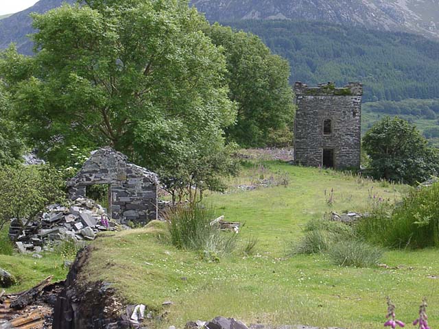
Work was sporadic until the mid-1880s: in 1883 six men produced 96 tons, and Ordnance Survey maps from 1889-90 show the quarry as disused. It was worked again on a small scale, perhaps into the 1930s. A loop and sidings on the North Wales Narrow Gauge Railway were built in 1902, reached by a tramway and an incline that may never have been finished, and there was once an aerial ropeway. At the incline head stands a square, castellated slate tower, perhaps a drumhouse later made into an office or dwelling, now a listed structure.
Geology
Unknown.
Workings
A small early pit followed by underground workings, forming three quarries linked by deep passages.
Closure
Disused by about 1890 after sporadic working; occasional small-scale working followed, perhaps until the 1930s.
What remains
The castellated tower stands among ruined buildings; the incline is mostly buried under slate waste.
A square castellated tower (a drumhouse or office), another two-storey building, dressing sheds, a brick building that held machinery in 1991, and the buried incline.
Redevelopment
Enclosed farmland.
Related mines
- Garreg Fawr Iron Mine — Worked together by the Garreg Fawr Slate and Mineral Company in the 1860s.
- Glanrafon Quarry — Gwyrfai valley slate quarries on the North Wales Narrow Gauge Railway.
Nearby mines
- Garreg Fawr Iron Mine — 0.4 miles (0.6 km) SE
- Alexandra Quarry — 1.8 miles (2.8 km) SW
- Moel Tryfan Quarry — 2.1 miles (3.3 km) SW
- Glynrhonwy Quarry — 2.7 miles (4.3 km) NE
- Drws-y-Coed Copper Mine — 3.0 miles (4.8 km) S
Straight-line distance, within 9 miles (15 km). Show on the map.
What's uncertain
Points where sources disagree or the record could not be settled; both accounts are kept. All open questions in the archive.
- The quarry worked occasionally on a small scale until the 1930s. (disputed) 1,3
- Slate workings at Garreg Fawr were in use at various times until sometime in the 1960s. (disputed) 2
Recorded claims
Individual factual claims, each attached to the source(s) that support it below. Where sources disagree, both are kept.
- Garreg Fawr began as a small pit working about 1802. 1,2,3
- In 1883 Garreg Fawr produced 96 tons with six men. 1
- In the 1860s the quarry was worked together with the Garreg Fawr iron mine by the Garreg Fawr Slate and Mineral Company. 3
- The quarry worked occasionally on a small scale until the 1930s. (disputed) 1,3
- Slate workings at Garreg Fawr were in use at various times until sometime in the 1960s. (disputed) 2
- A loop and sidings at Garreg Fawr on the North Wales Narrow Gauge Railway were built in 1902. 2
- At the head of the incline stands a square-plan castellated slate tower. 1,3
Sources
- (secondary) Garreg-Fawr Slate Quarry (NPRN 40554) — Coflein (RCAHMW)
- (secondary) Garreg Fawr — Festipedia (FR Heritage Group)
- (observational) Garreg Fawr Quarry — GeoTopoi (Graham Stephen)
Record created: 19 October 2026 · Last researched: 19 October 2026