 MineArchive
Worsley Navigable Levels
| Location | Worsley, City of Salford, Greater Manchester (historic Lancashire), Lancashire — 53.5010, -2.3833 (exact) |
|---|---|
| Commodity | Coal |
| Type | Coal |
| Worked | 1759–1887 |
| Operators | Francis Egerton, 3rd Duke of Bridgewater (1757–1803), Bridgewater Trustees (1803–?) |
Overview
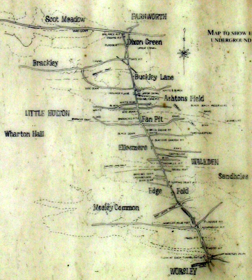
The Worsley Navigable Levels were an extraordinary system of underground canals, driven directly into Francis Egerton, 3rd Duke of Bridgewater's coal workings so that boats called starvationers could load coal at the coalface itself and float it straight out to the Bridgewater Canal.
History
Coal had been worked at Worsley from as early as 1376, and a first drainage sough was cut into the Duke of Bridgewater's estates there in 1729 under his predecessor, Scroop Egerton, the 1st Duke. Francis Egerton, the 3rd Duke, took control of the estate in 1757 at the age of 21 and, with his land agent John Gilbert, conceived the idea of extending the Bridgewater Canal underground directly into the coal workings, combining drainage and coal haulage in a single navigable level. The Bridgewater Canal Act passed in 1759 and construction, directed by the engineer James Brindley, was largely complete by 1764. The main level, 8 feet high with 4 feet of headroom and water clearance, first reached a workable seam -- the Worsley Four Foot mine -- 770 yards from its portal in 1761, and eventually extended some 4 miles underground; a further upper level, 1.75 miles long with a steep 1-in-4 gradient branch, was added in 1773. Between 1795 and 1797 an underground inclined plane 453 feet long was built to raise loaded boats 106.5 feet between levels using a counterbalanced system. Small boats known as 'starvationers' -- narrow, with prominent internal ribs, built to fit the tunnels as tightly as possible -- carried coal through the levels, in places propelled by 'legging', boatmen lying on their backs and walking their feet along the tunnel roof. By closure, the navigable levels totalled some 46 miles. Coal traffic through the levels ceased in 1887, though the system continued to be used for mine drainage, with boat inspections carried on until 1968. A description printed in 1769, while the work was young, gives the tunnel's first thousand yards as 6.5 feet wide and 7.5 feet high with 3 feet 4 inches of water, the boats 47 feet long, carrying seven to eight tons and towed by hand along a rail, linked six to twenty at a time. A second entrance tunnel was later cut at the Delph to relieve congestion, meeting the original about 500 yards in. More than 100,000 tons of coal a year came out this way until 1887, when the levels ceased to carry coal; they went on draining the collieries, water being pumped into them from the workings, until the closure of Mosley Common in 1968 made them redundant.
Geology
Coal of the Manchester field: the Worsley Four Foot seam, reached 770 yards from the portal in 1761, the levels doubling as an underground canal.
Workings
An underground canal system, its main level 8 feet high, reaching the Worsley Four Foot seam 770 yards from the portal in 1761 and eventually extending some 4 miles, with a further 1.75-mile upper level added in 1773 and a 453-foot underground inclined plane (1795-97) raising boats 106.5 feet between levels; narrow boats called starvationers carried coal directly from the coalface, in places propelled by 'legging'.
Closure
By the end of working the navigable levels totalled some 46 miles.
What remains
The two tunnel entrances survive at Worsley Delph, the old sandstone quarry beside Worsley Brook, with the remains of a starvationer boat near them; the levels themselves are flooded and closed.
The two tunnel portals at Worsley Delph, the quarry basin they open from, and the remains of a starvationer boat near the entrances.
Nearby mines
- Sandhole Colliery — 1.2 miles (1.9 km) N, Greater Manchester
- Mosley Common Colliery — 1.5 miles (2.5 km) W, Greater Manchester
- Linnyshaw Colliery — 1.7 miles (2.7 km) N, Greater Manchester
- Ellesmere Colliery — 1.7 miles (2.8 km) NW, Greater Manchester
- New Lester Colliery — 2.5 miles (4.0 km) NW, Greater Manchester
Straight-line distance, within 9 miles (15 km). Show on the map.
Recorded claims
Individual factual claims, each attached to the source(s) that support it below. Where sources disagree, both are kept.
- The Bridgewater Canal Act passed in 1759, and construction under engineer James Brindley was largely complete by 1764; the main level first reached the Worsley Four Foot seam, 770 yards from the portal, in 1761, and an underground inclined plane built 1795-97 raised loaded boats 106.5 feet between levels using a counterbalanced system. 1
- Small boats called 'starvationers', narrow and ribbed to fit the tunnels tightly, carried coal directly from the coalface through the levels, in places propelled by boatmen 'legging' -- lying on their backs and walking their feet along the tunnel roof; by closure the navigable levels totalled some 46 miles. 1
- Coal traffic through the levels ceased in 1887, though the system continued in use for mine drainage, with regular boat inspections carried on until 1968. 2
- The 1769 History of Inland Navigations describes the Duke's tunnel at Worsley Mill as a subterraneous navigation whose first 1,000 yards were 6.5 feet wide and 7.5 feet high with 3 feet 4 inches of water, already continued 500 yards further at 10 feet wide; the boats were 47 feet long and 4.5 feet wide, drew 2 feet 6 or 7 inches loaded and carried seven to eight tons, towed by hand along a rail on each side and linked six to twenty at a time, a boy of seventeen having worked 21 boats, or 147 tons. Over 100,000 tons of coal a year came out through the canal until 1887, after which it served for drainage until the closure of Mosley Common, the last pit in the area, in 1968 made it redundant. 3
- The underground canal was driven from Worsley Delph, an old sandstone quarry near Worsley Brook, at John Gilbert's suggestion; at one time a million tons of coal a year passed through the tunnel, and to relieve congestion a second entrance tunnel was cut, meeting the original about 500 yards in. Around 47 miles of underground canal on four levels were connected by a water-powered inclined plane and lifts, the main tunnels reaching as far north as Farnworth with side tunnels along the seams; the ribbed 'starvationer' boats, only 4.5 feet wide, were loaded at the coal face, and the remains of one lie near the tunnel entrances, with an example at the Boat Museum, Ellesmere Port. 4
Photographs & further reading
The wider history of the Duke of Bridgewater's colliery empire, of which the navigable levels were the signature engineering achievement.
View sourceSources
- (secondary) Worsley Navigable Levels — Wikipedia
- (secondary) Bridgewater Collieries — Wikipedia
- (secondary) Worsley Navigable Levels (Hidden Manchester Map, quoting Brindley and Egerton's History of Inland Navigations, 1769, and Salford LifeTimes) — Hidden Manchester
- (secondary) Worsley Delph and the Duke of Bridgewater's Underground Canals — Pennine Waterways
Record created: 2 September 2026 · Last researched: 24 September 2026