 MineArchive
Ventonwyn Mine
| Location | Hewas Water, St Stephen-in-Brannel, near St Austell, Cornwall — 50.3186, -4.8629 (approximate) |
|---|---|
| Commodity | Tin |
| Type | Metal |
| Worked | By 1889–c. 1907 (independently) |
| Maximum depth | About 350 feet (107 m), on a single observational account. |
| Operators | Ventonwyn Mining Syndicate |
Overview
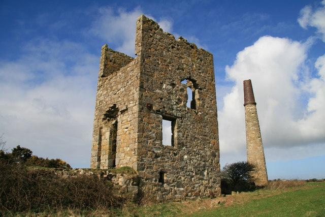
A small tin mine half a mile north-west of Hewas Water on the Truro to St Austell road, in the parish of St Stephen-in-Brannel, working the western extension of the Great Hewas lodes. Run for many years by its own Ventonwyn Mining Syndicate, it was photographed with its whole workforce in 1894, had its final independent working in 1903-07, and was then absorbed into the neighbouring Great Dowgas Mine, with which it was abandoned in 1913. Its stamps engine house and chimney still stand alone in a field beside the A390, one of the best-known landmarks on the road.
History
Ventonwyn was one of two smaller mines, with Hewas Water, that worked to the west of Great Hewas, the eighteenth-century mine around which the village of Sticker grew. A photograph taken in 1894, now in the Mac Waters Collection, shows the mine at work: the whole crew, surface and underground, lined up with the tools of their trades, a man holding a Cornish pump bucket, the sample taker with his vanning shovel, two blacksmiths with hammers, the engine driver with his oil can and the miners with candles stuck to their hats with clay, and the caption records that a single rotative beam engine both pumped the mine and drove a small battery of Cornish stamps. Cornish Mine Images gives the last working as 1903 to 1907 with 138 tons of tin produced; a photographer's account published in 2026 gives 167 tons of black tin between 1889 and 1909, after which the mine was abandoned, and a shaft about 350 feet deep. The mine was run separately by the Ventonwyn Mining Syndicate until, around 1907, its ground was worked as part of the combined operation with Great Dowgas, the tin and copper mine to the north-west that had been worked intermittently since about 1719; the abandonment plan for 'Dowgas Great and Ventonwyn Hewas St. Austell Consols', held by the Mining Remediation Authority, is dated 1 September 1913. Wikipedia's Sticker article says the last of the Great Hewas group ceased production in 1926, but nothing on record supports Ventonwyn itself working after 1913.
Geology
Ventonwyn sat on the western extension of the Great Hewas lodes, tin-bearing veins occupying fissures in the killas on the southern side of the St Austell granite; the neighbouring Great Dowgas mine developed five roughly parallel lodes trending south-east. The mine's own ore was cassiterite, 'black tin', crushed at the stamps beside the engine house.
Geological setting: Veins and Lodes (well documented example)
Workings
A single shaft, said to be about 350 feet deep, pumped by a rotative beam engine of 35-inch cylinder in the surviving engine house, which also drove a small battery of Cornish stamps; the mound beside the building is what remains of the dressing-floor waste. The mine was worked jointly with Great Dowgas in its final years, whose deep adit and Engine Shaft lay to the north-west.
Closure
Independent working ended around 1907, after which Ventonwyn's ground was worked with Great Dowgas until the combined mine was abandoned on 1 September 1913. Nothing is recorded of the reason; the small output suggests exhaustion of payable ground at the depth reached.
What remains
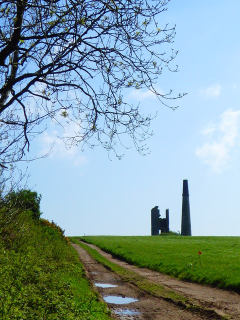
The engine house and chimney stand in the middle of a field near Ventonwyn farm, north of the A390, on private land; they were photographed as a well-known local landmark in 2008, again in 2018, and in 2026, when the stack and house were described as standing out on the ridgeline with the spoil mound beside them.
Stamps engine house and chimney, and a mound of dressing waste beside them.
Related mines
- Great Dowgas Mine — Worked jointly with Great Dowgas from about 1907 and abandoned with it in 1913 under the combined title 'Dowgas Great and Ventonwyn Hewas St. Austell Consols'.
- Great Hewas Mine — Ventonwyn was one of the two smaller mines that worked alongside Great Hewas, on the western extension of its lodes.
Nearby mines
- Hewas Water Mine — 0.3 miles (0.5 km) SE
- Great Dowgas Mine — 0.4 miles (0.6 km) NW
- Great Hewas Mine — 1.0 miles (1.6 km) E
- South Polgooth Mine — 1.7 miles (2.7 km) E
- Polgooth Mine — 2.1 miles (3.3 km) E
Straight-line distance, within 9 miles (15 km). Show on the map.
What's uncertain
Points where sources disagree or the record could not be settled; both accounts are kept. All open questions in the archive.
- Cornish Mine Images gives 138 tons of tin from the 1903-1907 working. (uncertain) 3
- A 2026 account gives 167 tons of black tin between 1889 and 1909, after which the mine was abandoned, and a shaft about 350 feet deep. (uncertain) 4
Recorded claims
Individual factual claims, each attached to the source(s) that support it below. Where sources disagree, both are kept.
- The mine lay half a mile north-west of Hewas Water on the Truro to St Austell road. 1,2
- An 1894 photograph shows the whole crew with the tools of their trades; its caption records that the rotative beam engine did the pumping as well as driving a small battery of Cornish stamps. 1
- The surviving engine house held a 35-inch cylinder rotative engine driving stamps. 2
- The mine was last worked in 1903-07. 3,2
- Cornish Mine Images gives 138 tons of tin from the 1903-1907 working. (uncertain) 3
- A 2026 account gives 167 tons of black tin between 1889 and 1909, after which the mine was abandoned, and a shaft about 350 feet deep. (uncertain) 4
- Ventonwyn worked the western extension of the Great Hewas lodes; it and Hewas Water mine worked alongside Great Hewas. 4,5
- Ventonwyn was run by the Ventonwyn Mining Syndicate and eventually amalgamated with Great Dowgas; the combined abandonment plan for 'Dowgas Great and Ventonwyn Hewas St. Austell Consols' is dated 1 September 1913. 6,7,4
- The engine house and chimney survive in a field near Ventonwyn farm as a well-known local landmark, photographed in 2008, 2018 and 2026. 4,2,8
Photographs & further reading
The 1894 photograph of the mine's workforce with the tools of their trades, and its caption on the engine and stamps.
View sourceA 2026 visit to the engine house with photographs and a short account of the mine's output and depth.
View sourceA photograph of the stamps engine house with the 1903-07 working dates and tin output.
View sourceSources
- (primary) Tin mine half a mile north-west of Hewas Water on the Truro to St Austell road (photograph, 1894, Mac Waters Collection, WAT_28_028) — cornishmemory.com (Azook CIC)
- (observational) Ventonwyn Mine (photograph and description, 26 February 2008) — John Gibson, Geograph Britain and Ireland, via Wikimedia Commons
- (secondary) St Austell Mines — Cornish Mine Images
- (observational) Frugal Film Project 2026: April, Roll 2 — Andrew Long, photographic blog on Cornwall's heritage
- (secondary) Sticker, Cornwall — Wikipedia
- (secondary) Ventonwyn Mine — Northern Mine Research Society
- (primary) Dowgas Great and Ventonwyn Hewas St. Austell Consols (mine abandonment plan, MRA OM6143) — British Geological Survey / Mining Remediation Authority
- (observational) Engine house and chimney at Ventonwyn Mine (photograph, 5 May 2018) — Rod Allday, Geograph Britain and Ireland, via Wikimedia Commons


Record created: 8 September 2026 · Last researched: 9 September 2026