 MineArchive
Upleatham Ironstone Mine
| Location | Upleatham and New Marske, near Saltburn, North Yorkshire — 54.5754, -1.0339 (approximate) |
|---|---|
| Commodity | Iron |
| Type | Ironstone |
| Worked | 1851–1923/24 |
| Maximum depth | Unknown. |
| Operators | Derwent Iron Company (1851–1857), Joseph Whitwell Pease & Co. (1857–1880), Pease & Partners Ltd. (1881–1924) |
Overview
A Cleveland ironstone mine of 1851 to 1923/24 under Upleatham Hill near New Marske, worked by the Derwent Iron Company and then the Pease firm, whose final extraction brought down more than half of Upleatham village.
History
Upleatham Ironstone Mine was opened in 1851 on the north side of Upleatham Hill, between Marske and Upleatham, soon after the discovery of ironstone on the hills at Eston. It was first worked by the Derwent Iron Company of Consett, from 1851 to 1857, then by Joseph Whitwell Pease & Co. from 1857 to 1880 and by Pease and Partners Ltd from 1881 until it closed. The new settlement of New Marske grew up to serve the drifts. Wikipedia gives 1861 for the mine's construction, but the parish population had already risen from 204 in 1841 to 1,007 in 1861, and Bulmer's directory of 1890 said the mines were opened about thirty-five years before.
It became one of the largest ironstone mines in Cleveland, worked from three winnings on the hillside, the Main, West Side and East Side. In 1883 it employed 718 people, and in 1890 Bulmer recorded about 500 men and boys raising some 700,000 tons a year from a seam 13 feet thick. William Cockburn was manager in 1865; W. Moore was agent and manager in the 1880s and C. Heslop in 1888.
For its first 36 years the ironstone under the village and Upleatham Hall was worked with pillars left to carry the surface. By 1889, with the mine nearing exhaustion, the stone left under the village was judged worth more than the buildings above it, and the Earl of Zetland, the landowner, agreed to let Pease and Partners take it, except what was needed to support the church, the school and the schoolmaster's house. Between 1890 and 1905 more than half the village, including the Hall, was lost to subsidence. The borough council's appraisal says nowhere else in Cleveland was so large a part of an established settlement sacrificed.
Employment fell from 508 in 1905 to 224 in 1923. The abandonment plans of the Main Pecten seam are dated 30 December 1923, and the Durham Mining Museum records the mine as abandoned in 1924.
Geology
The mine worked the Main seam of the Cleveland ironstone, recorded on the abandonment plans as the Main Pecten seam. Beneath Upleatham it was about 13 feet thick, one of the richest in Cleveland, and in 1890 the seam under the parish was estimated to hold 36,100,000 tons.
Workings
Drift mines driven into the north side of Upleatham Hill, worked by bord and pillar. The pillars were worked from the beginning outside the village, and under it from 1890. The mine was divided into the Main, West Side and East Side winnings, each with its own manager by 1888, and a narrow-gauge railway served the East Winning. The ironstone left the wood by Pontiac Road, the old mineral line.
Closure
The mine was approaching exhaustion by 1889, and the last large reserve was the stone left under the village. Employment fell to 224 by 1923; the Main Pecten seam was abandoned on 30 December 1923 and the mine is recorded as abandoned in 1924.
What remains
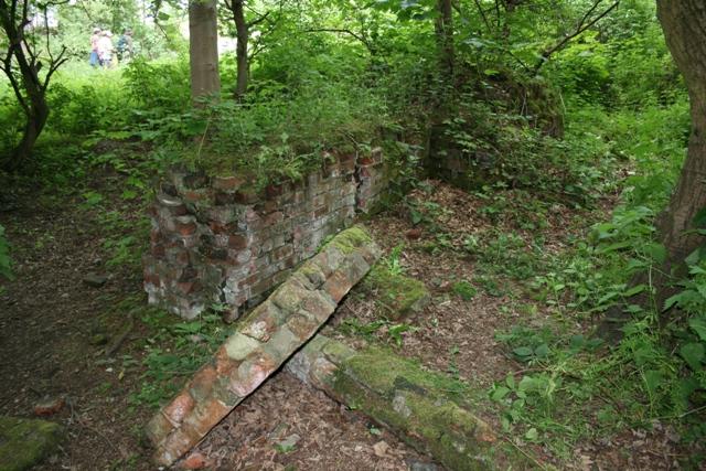
The workings lie under Errington Wood above New Marske, where brick foundations, among them the base of a ventilation fan, and a retaining wall are disappearing into the undergrowth. In 2013 a 13-foot ornamental gate at the top of Pontiac Road was dedicated to the men who worked the mine.
Brick foundations, including a ventilation-fan base and plinths for a hauling engine, a retaining wall, and the trackbed of the narrow-gauge railway to the East Winning, now a walkway through Errington Woods.
Redevelopment
The mine site is woodland. In Upleatham the sites of buildings lost to subsidence at the east end of the village were later sold as self-build plots, and twelve houses stand on them.
Related mines
- Eden Colliery — Both worked by the Derwent Iron Company of Consett: Eden Colliery in the 1840s, Upleatham from 1851 to 1857.
- Eston Ironstone Mines — Upleatham was opened soon after, and in consequence of, the discovery of ironstone on the Eston hills, and worked the same Main seam.
Nearby mines
- Kirkleatham Ironstone Mine — 1.7 miles (2.8 km) SW
- Waterfall Mine — 2.0 miles (3.2 km) S
- Chaloner Ironstone Mine — 2.3 miles (3.6 km) SW
- Longacres Mine — 2.7 miles (4.4 km) E
- Spa Mine — 3.0 miles (4.8 km) S
Straight-line distance, within 9 miles (15 km). Show on the map.
What's uncertain
Points where sources disagree or the record could not be settled; both accounts are kept. All open questions in the archive.
- The ironstone mine at Upleatham was constructed in 1861. (disputed) 4
Recorded claims
Individual factual claims, each attached to the source(s) that support it below. Where sources disagree, both are kept.
- The mine opened in 1851, worked from the north side of Upleatham Hill by drifts served by New Marske. 1,2,3
- The ironstone mine at Upleatham was constructed in 1861. (disputed) 4
- The mine was worked by the Derwent Iron Co. from 1851 to 1857, Joseph Whitwell Pease & Co. from 1857 to 1880 and Pease and Partners Ltd from 1881 to 1924. 2
- The mine employed 718 people in 1883, 508 in 1905 and 224 in 1923. 5
- In 1890 Pease & Partners employed about 500 men and boys at Upleatham, with an average output of about 700,000 tons a year from a seam 13 feet thick. 5
- In 1889 the Earl of Zetland agreed that Pease and Partners could extract the ironstone beneath Upleatham village, except what was needed to support the church, the school and the schoolmaster's house. 1
- Between 1890 and 1905 more than half of Upleatham village, including the Hall and its outbuildings, was lost to subsidence. 1
- The plans of the Main Pecten seam at Upleatham record its abandonment on 30 December 1923. 6
- The mine is recorded as abandoned in 1924. 5
- William Cockburn was manager in 1865, and in 1888 C. Heslop was agent and manager for the East Side, Main and West Side. 7
- In 2013 an ornamental gate by the artist Lewis Robinson was dedicated at the top of Pontiac Road to those who worked Upleatham Mine. 3
- A brick foundation for a ventilation fan survives in Errington Woods (2007 photograph). 8
Photographs & further reading
A 2007 photograph of a ventilation-fan foundation in Errington Woods, one of several by the same photographer of the mine's remains.
View sourceOwners, output and employment returns, the 1890 directory description and the names of those killed at the mine.
View sourceThe borough council's 2011 appraisal, with the history of the mine's extraction under the village and the subsidence that followed.
View sourceDatabase entry with the operators by date, the three winnings and a bibliography of NMRS publications.
View sourceSources
- (secondary) Upleatham Conservation Area Appraisal (2011) — Redcar and Cleveland Borough Council
- (secondary) Upleatham Mine - Buddlepit Mine Database — Buddlepit
- (secondary) Opening the gateway to Errington Wood's mining past (13 May 2013) — Teesside Live
- (secondary) Upleatham — Wikipedia
- (primary) Durham Mining Museum - Upleatham (Ironstone) — Durham Mining Museum
- (primary) BGS mine plans: Upleatham Nos. 1, 2, Mill, West (Main Pecten seam, abandoned 30 Dec 1923) — British Geological Survey / Mining Remediation Authority
- (primary) Durham Mining Museum - Upleatham (Ironstone): colliery management — Durham Mining Museum
- (observational) Foundations, Upleatham Ironstone Mine (Geograph, Mick Garratt, 2007) — Geograph
Record created: 1 October 2026 · Last researched: 1 October 2026