 MineArchive
Thankerton Colliery
| Also known as | Thankerton No. 1, Thankerton No. 6 |
|---|---|
| Location | Holytown, Motherwell, North Lanarkshire — 55.8278, -3.9979 (exact) |
| Commodity | Coal |
| Type | Coal |
| Worked | 1850–December 1953 (abandoned 1954) |
| Maximum depth | About 541 feet (165 m), No. 6 Pit |
| Operators | John McAndrew and Co. (?–1947), National Coal Board (1947–1953) |
Overview
John McAndrew and Co.'s colliery at Holytown, near Motherwell, worked from 1850 and employing over 700 men in the 1940s. Its four shafts, the deepest 165 metres, raised steam and house coal until December 1953.
History
Thankerton Colliery lay at Holytown, near Motherwell, in the parish of Bothwell. It is dated from 1850 and was worked by John McAndrew and Co., later John McAndrew and Co. Ltd. The Lists of Mines return 231 people in 1894, 393 in 1905 and 530 in 1910, raising household and steam coal from the Blackband, Lower and Upper Drumgray and Virtuewell, with the Main and Pyotshaw by 1920. A manager was convicted in 1887 for failing to fence off a place into which a brusher, Bernard Trayner, went with a naked light and was killed, and in August 1905 two men were killed when a hutch on which they were riding, one of them illegally, left the rails and knocked out the road timbering.
The colliery grew to 670 people in 1933 and 730 in 1947, when it raised 146,000 tons of gas, household and steam coal; the national record gives its peak workforce as 766 that year. It worked from four shafts: No. 1, 59 metres deep, No. 3, 37 metres, and No. 6, 165 metres, with No. 2 nearby and a No. 6A sunk in 1949. In 1948, under the National Coal Board, it raised about 600 tons a day, 160,000 to 180,000 tons a year, by longwall working with hand-driven roads and 736 employees; it had screening tables at Nos. 1 and 6 and an obsolete bash washer, an ambulance room at each pit but no baths or canteen, and also sold blaes.
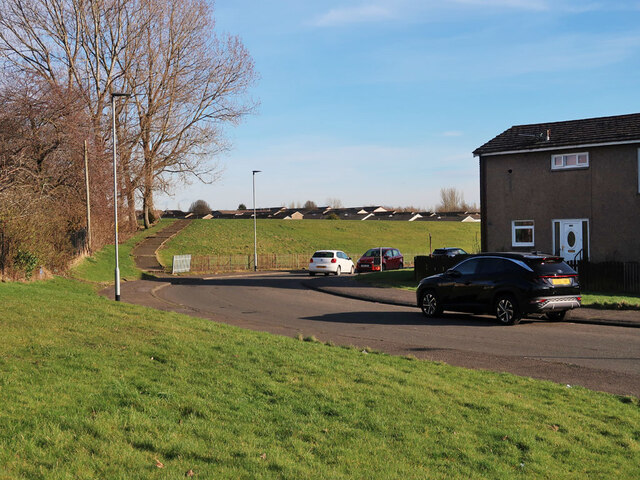
Thankerton closed in December 1953, and its last plans, of the Ell, Kiltongue, Virgin, Drumgray and other seams, were lodged in 1953 and 1954. Houses now stand on the old mining ground at Holytown.
Geology
Lanarkshire coalfield: the Blackband ironstone, Lower and Upper Drumgray, Virtuewell, Main, Pyotshaw, Ell (top, mid and lower leaves), Kiltongue, Virgin, Shotts Gas and Balmoral seams.
Workings
Four shafts: No. 1 (59 m), No. 3 (37 m), No. 6 (165 m) and No. 6A (1949), with No. 2 nearby; longwall working with hand-driven roads; screening tables and a bash washer.
Closure
Closed by the National Coal Board in December 1953; the abandonment plans of its many seams are dated 1953 and 1954.
What remains
Houses and a recreation ground occupy the former mining ground; the No. 4 pit lay on the recreation ground.
Redevelopment
Housing has been built on the old mining area at Holytown.
Nearby mines
- Milnwood Colliery — 0.7 miles (1.1 km) S
- Rosehall Colliery — 1.4 miles (2.2 km) W
- Tannochside Colliery — 1.8 miles (3.0 km) W
- Carnbroe Colliery — 2.0 miles (3.2 km) W
- Motherwell Colliery — 2.5 miles (4.0 km) S
Straight-line distance, within 9 miles (15 km). Show on the map.
Recorded claims
Individual factual claims, each attached to the source(s) that support it below. Where sources disagree, both are kept.
- Thankerton Colliery, Holytown, is dated 1850 to December 1953. 1,2
- It had four shafts: No. 1, 59 m, No. 3, 37 m, and No. 6, 165 m deep, with No. 6A sunk in 1949. 2
- Thankerton employed 231 people in 1894, 530 in 1910 and 730 in 1947, when it raised 146,000 tons. 3
- In 1948 it raised about 600 tons a day, 160,000 to 180,000 tons a year, with 736 employees. 2
- In 1887 a brusher was killed after going into an unfenced place with a naked light, and the manager was convicted for not having it fenced off. 3
- The Kiltongue workings at Thankerton were abandoned in 1953. 4
- Housing now covers the old mining area, and Thankerton's No. 4 pit was on the recreation ground there. 5
Photographs & further reading
The national record of the colliery, its four shafts and 1948 details.
View sourceOwners, employment, seams and those killed at the colliery.
View sourceSources
- (secondary) NCB Collieries - Scotland (Northern Mine Research Society) — Northern Mine Research Society
- (secondary) Thankerton No.1 Mine (NRHE 132415) — Historic Environment Scotland (trove.scot, formerly Canmore)
- (primary) Thankerton Colliery — Durham Mining Museum
- (primary) BGS mine plan: Thankerton, Kiltongue, abandoned 1953 — BGS / Mining Remediation Authority mine plans
- (observational) Windsor Road, Holytown (Geograph 6785922) — Geograph
Record created: 4 October 2026 · Last researched: 4 October 2026