 MineArchive
Pumpherston No. 6 Mine
| Location | Pumpherston, West Lothian — 55.9053, -3.4716 (approximate) |
|---|---|
| Commodity | Oil Shale |
| Type | Mineral |
| Worked | After 1907–1912 |
A short-lived Broxburn Shale mine just south of Pumpherston Oil Works in West Lothian, worked for about five years until 1912, whose engine-house plinths still stand.
Location
Approximate location. The large pin is this mine; the small round markers are the nearest mines on record. Click one for its page. View on full map
History
Pumpherston No. 6 was a short-lived shale mine less than a mile south of Pumpherston Oil Works, which it served: an inclined adit into the Broxburn Shales. It was opened after 1907 (one account gives that year itself) and worked for only about five years. When it was abandoned in 1912 its plan recorded workings in the Broxburn, Big, Lower Big, Curly and Wild shales. It came and went between Ordnance Survey editions, and appears on no old map of the area.
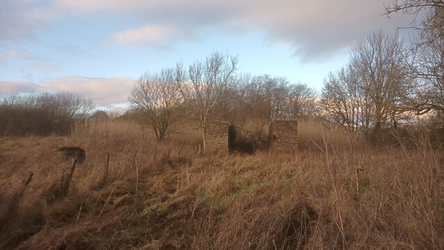
What's left is the base of its haulage engine house: two very substantial brick plinths, each about 5 feet thick and perhaps 25 feet long, with square sockets halfway up their inner faces that probably held the beams carrying the engine. A modest bing of waste shale lies close by, and trees and shrubs cover the site of the adit. Immediately to the north, reed beds were built around 2000 as part of the clean-up of the oil works site.
Geology
The Broxburn Shales of the West Lothian Oil-Shale Formation: the Broxburn, Big, Lower Big, Curly and Wild shales.
Workings
An inclined adit into the Broxburn Shales, worked by a haulage engine at the surface.
Closure
Abandoned in 1912.
What remains
Woodland and open space, with reed beds of about 2000 to the north.
Two thick brick plinths, the base of the haulage engine house, and a modest bing of waste shale.
Nearby mines
- Pumpherston No. 5 Mine — 0.2 miles (0.3 km) NW
- Pumpherston No. 1 Mine — 0.7 miles (1.1 km) NW
- Roman Camp No. 7 Mine — 0.7 miles (1.2 km) N
- Roman Camp No. 1 Mine — 0.8 miles (1.3 km) NW
- Oakbank No. 1 and 2 Pits — 1.0 miles (1.5 km) S
Straight-line distance, within 9 miles (15 km). Show on the map.
Further reading
The Museum of the Scottish Shale Oil Industry's page: seams, dates, the engine-house plinths and photographs of the site.
View sourceThe national catalogue entry for the mine's 1912 abandonment plan.
View sourceA 2024 photograph of the engine-house walls, with the photographer's measurements and notes on the spoil heap.
View sourceSources
- (secondary) Pumpherston No.6 mine (Scottish Shale) — Scottish Shale
- (primary) BGS mine plans: Pumpherston No. 6, Broxburn shales, abandoned 1912 (5870) — British Geological Survey
- (observational) Remnants of Pumpherston No. 6 mine (Geograph) — Geograph
Record created: 20 November 2026 · Last researched: 20 November 2026