 MineArchive
Preston Island Colliery
| Location | Torry Bay, off Low Valleyfield, between Torryburn and Culross, Fife — 56.0533, -3.6000 (approximate) |
|---|---|
| Commodity | Coal |
| Type | Coal |
| Worked | By 1807 (sinking from c. 1800)–1811 |
| Maximum depth | About 276 feet (George Pit) |
| Operators | Sir Robert Preston (1800–1811) |
Overview
A colliery built on an artificial island in Torry Bay, off Low Valleyfield, by Sir Robert Preston after 1800 to fire salt pans. Three pits were sunk, the deepest 276 feet, but a firedamp explosion in 1811 ended the mining at a loss of some £30,000; the ruins still stand.
History
Preston Island was built on Craigmore Rock, a half-tide reef in Torry Bay between Torryburn and Culross, by Sir Robert Preston, 6th Baronet, who inherited the Valleyfield estate in 1800. Finding traces of coal on the rock, which lay above low water and so was part of his property, he had a sea wall built, levelled the interior above high tide and sank three pits: the Eye Pit, 52 feet deep, the Lady Anne, 75 feet, and the George, 276 feet. The colliery was working by 1807, when a steam engine was ordered from the Carron Iron Works, and the island gained winding and pumping engine houses, miners' accommodation and a piped water supply.
The coal fed salt pans on the island, and the two depended on each other. In 1811 a firedamp explosion in the George Pit, working the Lochgelly Splint about 250 feet down, killed the men at work there. In 1813 thirteen colliers were still raising 141 tons a fortnight, but the mine lost money and was kept going only by the salt, and Preston gave up the colliery after losing some £30,000.
Salters leased the island and stayed on after Preston's death in 1834, though the repeal of the salt duties in 1823 had already undercut the works. The last of them turned to illicit distilling in the 1850s and fled when the authorities were alerted, and the island was abandoned. Since 1979 it has been enclosed in an ash lagoon of Longannet Power Station and is no longer an island; the ruins of its engine houses, pit buildings and salt pan houses survive and were excavated in 1993.
Geology
Fife Coal Measures cropping out on Craigmore Rock: Laurie Graham's Coal, the Six Foot, Nine Foot and Five Foot coals and thin ironstones, correlated with Valleyfield's Blairhall Main, Milton Main and Diamond; the George Pit worked the Lochgelly Splint at about 250 feet.
Workings
Three pits on the reclaimed island: the Eye (52 ft), Lady Anne (75 ft) and George (276 ft); winding and pumping engine houses with a steam engine from the Carron Iron Works (1807); salt pans and pan houses; a sea wall and pier.
Closure
Abandoned after a fatal firedamp explosion in the George Pit in 1811; the mine was already losing money and was supported only by the salt pans.
What remains
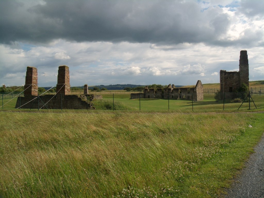
The ruins of the engine houses, pit buildings and salt pan houses survive, enclosed by the ash lagoons of Longannet Power Station.
Ruined engine houses, chimney stacks, pit buildings and salt pan houses.
Redevelopment
Since 1979 the island has been enclosed in an ash lagoon of Longannet Power Station, which has joined it to the shore.
Nearby mines
- Valleyfield Colliery — 0.6 miles (0.9 km) NE
- The Moat Pit — 1.2 miles (2.0 km) W
- Blairhall Colliery — 1.7 miles (2.8 km) N
- Carriden Colliery — 2.3 miles (3.7 km) S, Falkirk
- Bridgeness Colliery — 2.7 miles (4.3 km) S, Falkirk
Straight-line distance, within 9 miles (15 km). Show on the map.
Recorded claims
Individual factual claims, each attached to the source(s) that support it below. Where sources disagree, both are kept.
- Sir Robert Preston sank three pits on the island, the Eye (52 ft), the Lady Anne (75 ft) and the George (276 ft). 1,2
- The colliery was in operation by 1807, when a steam engine for it was ordered from the Carron Iron Works. 2
- A fatal firedamp explosion occurred in 1811, after which the mine was closed. 1,3,2
- Preston abandoned the project after the 1811 explosion, having lost about £30,000. 2
- Since 1979 Preston Island has been enclosed in a lagoon of Longannet Power Station's ash. 1,3
- The ruins of the salt pan and colliery complex on Preston Island date from the late eighteenth and early nineteenth centuries and still stand. 2,4
Photographs & further reading
The excavation report, with the island's history, buildings and salt pans.
View sourceThe pits, seams, salt works and later history, with photographs.
View sourceSources
- (secondary) Preston Island Colliery — Fife Pits and Memorial Book (Michael Martin)
- (secondary) Preston Island: archaeological research and excavations (Ewart, Stewart and Dunn, Tayside and Fife Archaeological Journal 2, 1996) — Tayside and Fife Archaeological Committee
- (secondary) Preston Island — Wikipedia
- (observational) Preston Island - salt pan and colliery complex (Geograph 2500619) — Geograph
Record created: 4 October 2026 · Last researched: 4 October 2026