 MineArchive
Polton Colliery
| Location | South side of Bonnyrigg, Midlothian — 55.8674, -3.1049 (exact) |
|---|---|
| Commodity | Coal |
| Type | Coal |
| Worked | by 1871–after 1954 |
| Operators | Polton Coal Company (1881–1883) — Polton Coal Co. (Limited), Polton Colliery and Fireclay Works; in liquidation 1883 (Scottish Brick History) Lothian Coal Company (?–1947, owner) — Lothian Coal Co., Ltd., with Whitehill Colliery and the brickworks under one general manager (DMM, Scottish Brick History) National Coal Board (1947–?) — A pumping station by 1954 (DMM) |
A coal and fireclay pit on the southern edge of Bonnyrigg, sold off with its brickworks by the failing Polton Coal Company in the 1880s, worked by the Lothian Coal Company into the 1920s and kept as a pumping station under the National Coal Board.
Location
Recorded location. The large pin is this mine; the small round markers are the nearest mines on record. Click one for its page. View on full map
History
Polton Colliery lay on the southern edge of Bonnyrigg, about seven miles south-south-east of Edinburgh. A pit was being sunk there in 1871, when a blacksmith was killed after the winding drum ran away and dropped the kettle he was riding into ten fathoms of water. In the early 1880s the colliery belonged to the Polton Coal Company Ltd, which also ran a fireclay and brickworks beside it. Colliery and brickworks were advertised for sale in 1881 and repeatedly through 1883, together with the miners' houses and a newly erected pumping engine. The advertisements said the pits had won five workable seams of coal, four of them resting on good fireclays and the fifth worked in connection with oil shale. By November 1883 the company was in liquidation.
The Lothian Coal Company later held Polton alongside its Whitehill Colliery at Rosewell; the two pits and their brickworks shared a general manager. Polton employed 245 in 1894, 479 in 1905 and 436 in 1920, working the Jewel and Splint coals and later the Rough as well. It was served by sidings off the Peebles Railway. In January 1910 a miner and a drawer were drowned when the workings holed into an unknown old waste. By 1954, under the National Coal Board, Polton was a pumping station manned by three.
Geology
Coals of the Midlothian coalfield: the Jewel, Splint and Rough, with plans also for the Parrot and Great Seam. Four of the seams rested on fireclay, and one was worked together with oil shale.
Workings
Shafts working the Jewel, Splint and Rough coals, with at least two pits, Polton Colliery No. 1 and No. 2, on sidings off the Peebles Railway. Abandonment plans titled Polton survive for workings given up between 1864 and 1900.
Closure
Coal working had given way to pumping by 1954, when the National Coal Board kept Polton as a pumping station with three men. The date of final closure is unknown.
What remains
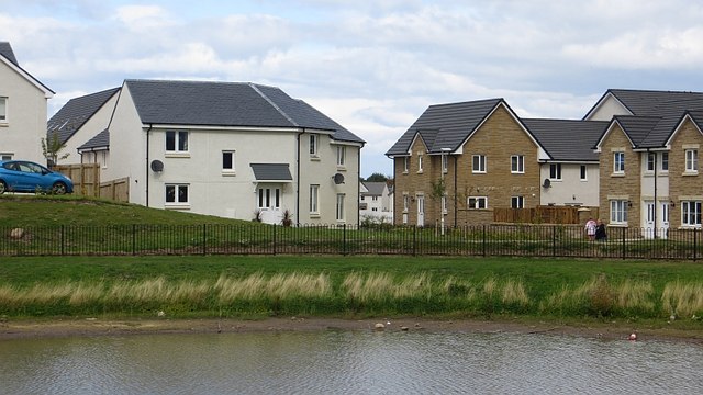
The site lies within the large twenty-first-century housing development on the south side of Bonnyrigg. The pithead buildings stood where Burnbank Park and its balancing pond are now, and a playground occupies the site of a bing.
Redevelopment
Housing and Burnbank Park, part of the southern expansion of Bonnyrigg; the new streets include Auld Coal Avenue, Auld Coal Crescent and Auld Coal Terrace.
Related mines
- Whitehill Colliery — Both were Lothian Coal Company pits run with their brickworks as the Whitehill and Polton Collieries under one general manager.
Nearby mines
- Eldin Colliery — 0.5 miles (0.8 km) N
- Lady Victoria Colliery — 1.5 miles (2.4 km) E
- Newbattle Collieries — 1.5 miles (2.4 km) E
- Easthouses Pit — 1.8 miles (2.8 km) E
- Whitehill Colliery — 1.7 miles (2.8 km) SW
Straight-line distance, within 9 miles (15 km). Show on the map.
Further reading
Owners, employment, seams and recorded deaths at the colliery.
View sourceThe Polton Coal Company's colliery and brickworks, their 1880s sale and later Lothian Coal Company ownership.
View sourceSources
- (primary) Polton Colliery (Durham Mining Museum) — Durham Mining Museum
- (secondary) Polton Colliery and Brickworks, Polton, Midlothian (Scotland's Brick and Tile Manufacturing Industry) — Scottish Brick History
- (secondary) Polton Colliery No 2 (RAILSCOT) — RAILSCOT
- (primary) BGS mine plan: POLTON, Jewel, abandoned 1900 — British Geological Survey
- (observational) Polton Colliery site, Richard Webb (Geograph 4154958) — Geograph
Record created: 5 November 2026 · Last researched: 6 November 2026