 MineArchive
Nant Gwrtheyrn Quarries
| Also known as | Porth y Nant Quarry, Cae'r Nant Quarry, Carreg y Llam Quarry, Port Nant |
|---|---|
| Location | Nant Gwrtheyrn, below Llithfaen on the north coast of the Llŷn peninsula, Gwynedd — 52.9723, -4.4631 (exact) |
| Commodity | Granite |
| Type | Stone |
| Worked | 1851–1939 |
| Maximum depth | Surface quarrying in hillside terraces; no depth figure applies. |
| Operators | Kneeshaw and Lupton (1861–?), Amey Roadstone Corporation (?–1978) |
Overview
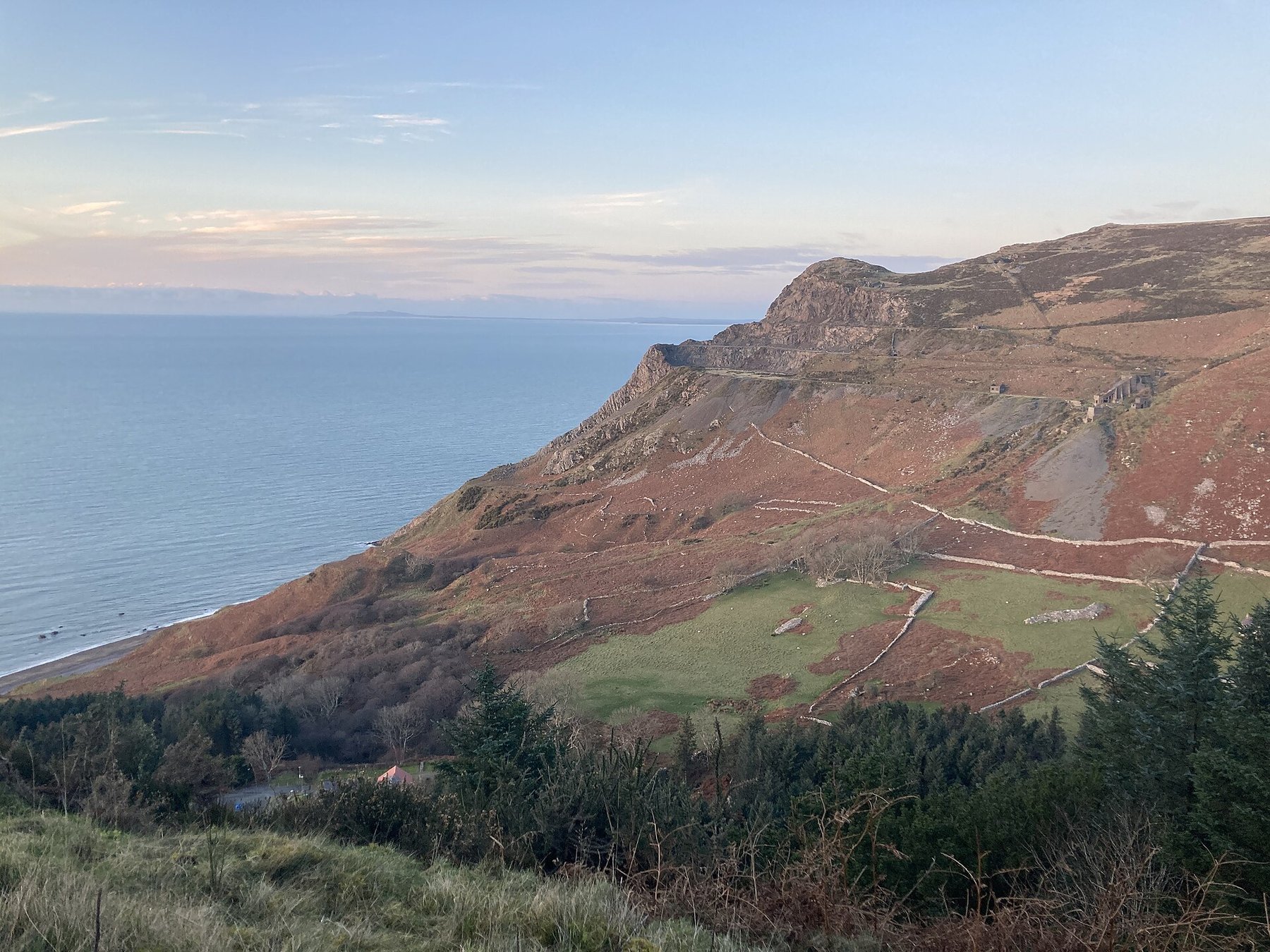
Three granite quarries — Cae'r Nant, Porth y Nant and Carreg y Llam — cut into the seaward flank of Yr Eifl on the Llŷn peninsula, worked from the 1850s for setts to pave the streets of Liverpool, Manchester and Birkenhead. There was no road worth the name, so ships loaded at jetties in the bay. The village built for the quarrymen emptied after the quarries closed, was wrecked by squatters in the 1970s, and was rescued to become the Welsh language centre it is today.
History
In the middle of the nineteenth century Nant Gwrtheyrn held three farms and little else. The expanding cities of Lancashire needed hard road surfaces, and granite setts — rectangular blocks dressed by hand — were in heavy demand. The first sett quarry in the valley opened in 1851 under Hugh Owen of Anglesey; in 1861 the Liverpool firm of Kneeshaw and Lupton took control and opened a quarry on the southern side of the bay. Jetties were built so that steamers could carry the setts to Liverpool, Manchester and Birkenhead, returning with goods the valley could not otherwise get.
A terrace of small houses went up soon after the quarry opened. In 1878, as the workforce was joined by wives and children, two more terraces of 26 houses were built at right angles further up the valley — Sea View facing the beach and Mountain View facing the quarry — together with the Plas, a large house for the quarry manager, and Capel Seilo, built in 1875 for the Calvinistic Methodists. By the 1886 census 200 people lived there. The settlement was called Port Nant until 1910, when an inspector of education, Lewis Jones Roberts, proposed replacing the hybrid name with Nant Gwrtheyrn.
By the 1890s three quarries were working — Cae'r Nant, Porth y Nant and Carreg y Llam — and ships of 150 to 200 tons loaded regularly in the bay. A landslide in 1925 destroyed the barracks. Demand for granite road setts then fell away sharply as tarmacadam took over; the Porth y Nant owners amalgamated after the First World War and the quarry was eventually closed by the Roadstone Corporation. The last quarry shut at the outbreak of war in 1939, and the families left one by one. The school closed in 1948 and the last family left in 1959.
Geology
The quarries worked the igneous rock of Yr Eifl, on the north coast of the Llŷn peninsula — a hard, close-grained granitic stone tough enough to stand up as a road surface under iron tyres and horseshoes, which is precisely why it was worth carrying by sea to Lancashire. The rock's ability to be split and dressed into regular rectangular blocks is what made the sett trade possible here.
Workings
Three separate quarries on the steep seaward slopes, worked from terraces cut into the hillside with inclines running down to the shore. Setts were dressed into shape by hand at the quarry rather than shipped as rough block. Because the valley's only land access was a track so steep it reached one in three in places, everything moved by sea: three jetties in the bay took ships of 150 to 200 tons. Remains at Porth y Nant include quarry buildings, a tramway incline and the jetty.
Closure
Demand for granite setts collapsed between the wars as road surfacing changed. The Porth y Nant owners amalgamated after the First World War and the quarry was closed by the Roadstone Corporation; the last working quarry in the valley shut when war broke out in 1939, partly for want of demand and partly because of transport difficulties. The village outlived the quarries by twenty years, the last family leaving in 1959.
What remains
The village survives and is in use: after the quarries closed the houses stood empty, were occupied unofficially through the 1960s, and in the early 1970s were badly damaged by a commune whose members burned floors and doors for firewood and left the buildings in ruins. Dr Carl Clowes, a local GP, formed a trust to buy and restore them as a Welsh language centre; after six years of campaigning the Porth y Nant property was transferred from the Amey Roadstone Corporation to Ymddiriedolaeth Nant Gwrtheyrn in July 1978 for £25,000. The terraces, the Plas and Capel Seilo are now the Nant Gwrtheyrn Welsh Language and Heritage Centre. The quarry workings themselves stand disused above and around it, with buildings, a tramway incline and the jetty surviving at Porth y Nant.
Quarry buildings, a tramway incline and the jetty at Porth y Nant, the terraced workings on the hillside, and the restored quarry village — Sea View and Mountain View terraces, the manager's house and the 1875 chapel.
Redevelopment
The quarry village was bought by a trust in 1978 and restored as Nant Gwrtheyrn, a residential Welsh language and heritage centre — an unusually complete second life for a quarrying settlement.
Nearby mines
- Trefor Granite Quarry — 1.3 miles (2.1 km) NE
- Dorothea Quarry — 8.3 miles (13.4 km) NE
- Vron Quarry — 9.2 miles (14.9 km) NE
Straight-line distance, within 9 miles (15 km). Show on the map.
What's uncertain
Points where sources disagree or the record could not be settled; both accounts are kept. All open questions in the archive.
- Nant Gwrtheyrn's own history dates the first sett quarry in the valley to 1851 under Hugh Owen of Anglesey, with the Liverpool firm Kneeshaw and Lupton taking control in 1861; other accounts give 1861 as the opening date and Kneeshaw and Lupton as the opener, while Coflein says only that modern quarrying started shortly after 1850. (uncertain) 1,2,3
Recorded claims
Individual factual claims, each attached to the source(s) that support it below. Where sources disagree, both are kept.
- Nant Gwrtheyrn's own history dates the first sett quarry in the valley to 1851 under Hugh Owen of Anglesey, with the Liverpool firm Kneeshaw and Lupton taking control in 1861; other accounts give 1861 as the opening date and Kneeshaw and Lupton as the opener, while Coflein says only that modern quarrying started shortly after 1850. (uncertain) 1,2,3
- The main output was rectangular granite setts, dressed to shape at the quarry, for paving the streets of the Lancashire towns and cities; ships loaded at purpose-built jetties for Liverpool, Manchester and Birkenhead. 1,3
- By the 1890s three quarries were working in the valley — Cae'r Nant, Porth y Nant and Carreg y Llam — with ships of 150 to 200 tons loading regularly. 1,2
- A first terrace went up soon after the quarry opened; in 1878 two further terraces of 26 houses, Sea View and Mountain View, were built at right angles further up the valley, with the Plas for the manager and Capel Seilo of 1875 for the Calvinistic Methodists. The 1886 census recorded 200 inhabitants. 2,3
- The settlement was called Port Nant until 1910, when Lewis Jones Roberts, an inspector of education, proposed replacing the hybrid name with Nant Gwrtheyrn. 2
- The last quarry closed at the outbreak of war in 1939, partly through falling demand and partly through transport difficulties; the school closed in 1948 and the last family left in 1959. 2,4
- The Porth y Nant property was transferred from the Amey Roadstone Corporation to Ymddiriedolaeth Nant Gwrtheyrn in July 1978 for £25,000, after a campaign begun by Dr Carl Clowes in 1972, and the village became a residential Welsh language centre. 2,4
- A landslide in 1925 destroyed the quarry barracks. 2
Photographs & further reading
The national monuments record for the quarry, naming the three workings in the valley and listing what survives at Porth y Nant — buildings, a tramway incline and the jetty.
View sourceAn account of the village as it was and as it became, with photographs of the terraces, the Plas, the chapel and the one-in-three track known as the Corkscrew.
View sourceThe centre's own dated timeline of the valley, from the opening of the first sett quarry through the building of the terraces and chapel to the 1978 purchase that saved the village.
View sourceSources
- (primary) Porth y Nant Stone Quarry (NPRN 40566) — Royal Commission on the Ancient and Historical Monuments of Wales
- (secondary) The History of Nant Gwrtheyrn — Nant Gwrtheyrn Welsh Language and Heritage Centre
- (observational) Porth y Nant — Abandoned Communities
- (secondary) Nant Gwrtheyrn — Wikipedia
Record created: 3 September 2026 · Last researched: 3 September 2026