 MineArchive
Mynydd Gorddu Mine
| Also known as | Mynyddgorddu Mine |
|---|---|
| Location | About a mile west of Bont-goch (Elerch), Ceredigion — 52.4556, -3.9713 (exact) |
| Commodities | Lead, Silver, Zinc |
| Type | Metal |
| Worked | c. 1870–1884 |
| Maximum depth | 46 fathoms below the adit (about 84 m) |
Mynydd Gorddu was a small lead mine about a mile west of Bont-goch, in the hills east of Bow Street, started about 1870 after large blocks of solid galena were found near the outcrop. It worked from 1874 to 1884, by which time the single shoot of ore that made it was probably exhausted. It returned 901 tons of lead ore and 9,725 ounces of silver.
Location
Recorded location. The large pin is this mine; the small round markers are the nearest mines on record. Click one for its page. View on full map
History
The mine began with a find at surface: large blocks of solid galena near the outcrop of the lode, about 1870. Burnett's engine shaft was sunk vertically to 46 fathoms below a shallow adit, cross-cuts were driven to the lode, and levels were opened at 12, 24, 34 and 46 fathoms.
Development showed what the surface find amounted to. The rich ore was a single shoot, leaning west at about 30 degrees from the vertical and short along the lode: some 32 fathoms long in the three upper levels and less than 20 in the bottom one. Within those limits it was good ground, yielding about 18 hundredweight of lead ore to the square fathom.
Ore was returned in each of the eleven years from 1874 to 1884. The total was 901 tons of lead ore, which gave 675 tons of lead and 9,725 ounces of silver, with 183 tons of blende. The best year was 1880, with 240 tons of galena and 40 of blende. Work stopped in 1884.
Geology
The ore lay in one shoot inclined west at about 30 degrees from the vertical, with a sharply defined eastern edge and a vaguer western one. The productive ground of the neighbouring Penycefn lode runs on in the same direction as the Hafan lode between Cefngwyn and this mine.
Geological setting: Veins and Lodes (well documented example)
Workings
Burnett's engine shaft goes down vertically 46 fathoms below a shallow adit, about 680 feet above sea level, whose mouth is 100 yards to the south-west. Levels were driven at 12, 24, 34 and 46 fathoms. A cross-cut north-west from the 12-fathom level, put out to prove the ground on that side, met nothing of value, and a branch striking south-west was tried for some distance in the same level.
Closure
Work stopped in 1884, the last year for which ore was returned. The shoot of ore was probably exhausted.
What remains
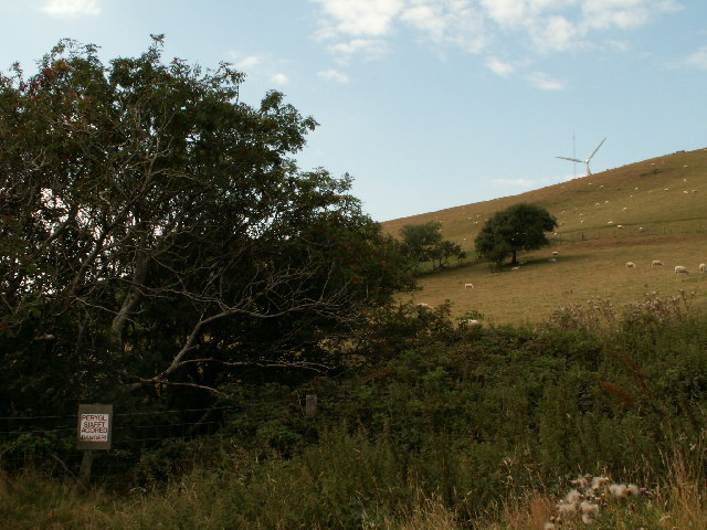
In 2005 a shaft on the southern slope of Mynydd Gorddu stood open in a fenced clump of trees, with a warning sign, on a hill by then shared with wind turbines.
Nearby mines
- Elgar Mine — 0.0 miles (0.0 km) E
- Court Grange Mine — 0.5 miles (0.8 km) SW
- Cefngwyn Mine — 1.2 miles (2.0 km) NE
- Bronfloyd Mine — 1.6 miles (2.5 km) S
- Leri Valley Mine — 1.7 miles (2.7 km) NE
Straight-line distance, within 9 miles (15 km). Show on the map.
Further reading
The Royal Commission's site record, with Arthur Chater's photographs of 1968 showing the wheelpit, aqueduct and mine cottage.
View sourceSources
- (primary) Lead and Zinc: The Mining District of North Cardiganshire and West Montgomeryshire (Special Reports on the Mineral Resources of Great Britain, vol. XX), O. T. Jones, 1922 — Memoirs of the Geological Survey
- (primary) Mynydd Gorddu Lead Mine (NPRN 409152) — Coflein, Royal Commission on the Ancient and Historical Monuments of Wales
- (observational) Abandoned mineshaft, Mynydd Gorddu (photograph, 19 August 2005) — Geograph
- (primary) Mine plan: Mynyddgonddu and Elgar Mine, location, notes and section, SN68NE 4 (KP16902) — British Geological Survey
Record created: 18 November 2026 · Last researched: 18 November 2026