 MineArchive
Llawrcwmbach Mine
| Also known as | Llawr-y-cwm-bach Mine, Llawr-y-Cwm Bach Mine |
|---|---|
| Location | North side of the Leri valley, below the Craigypistyll waterfall, Trefeurig, Ceredigion — 52.4513, -3.9040 (exact) |
| Commodity | Lead |
| Type | Metal |
| Worked | by 1859 |
| Maximum depth | About 30 fathoms (about 55 m) |
Llawrcwmbach was a lead mine on the north side of the upper Leri valley, just below the Craigypistyll waterfall and about seven miles from Bow Street. It worked branches of the Camdwr lode, mostly from a shaft about 30 fathoms deep, and returned 477 tons of lead ore, with a best year of 100 tons in 1859. Ore from other small mines was brought here to be dressed. Its tips and ruins stand beside the farm of the same name.
Location
Recorded location. The large pin is this mine; the small round markers are the nearest mines on record. Click one for its page. View on full map
History
The mine is hard to reach by road. Ore was brought to it all the same: in the later days of the Pengraigddu mine, several miles away, what was raised there was carried here on horseback to be dressed.
Its own ore came from branches of the Camdwr lode, which runs along the valley floor to the south. Most of it was raised from a single shaft about 30 fathoms deep, though it is possible the main lode itself was reached at depth. Lead ore was returned over a long run of years to a total of 477 tons. The best year was 1859, with 100 tons.
Geology
The workings appear to be on branches of the Camdwr lode, which passes along the valley floor to the south and throws the lowest beds of the Frongoch formation against the Gwestyn shales.
Geological setting: Veins and Lodes (historical documentary reference)
Workings
Most of the ore was worked from a shaft about 30 fathoms deep.
Closure
The year of the last return is not recorded.
What remains
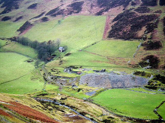
In 2020 a large grey spoil tip and roofless mine buildings stood beside the farmstead, on green valley-side pasture below slopes of heather.
A large spoil tip and ruined buildings beside the farm.
Related mines
- Pengraigddu Mine — Ore from Pengraigddu was carried several miles on horseback to Llawrcwmbach to be dressed.
Nearby mines
- Cwmsymlog Mine — 1.1 miles (1.8 km) S
- Gwaith Yr Afon Mine — 1.5 miles (2.3 km) SW
- Llettyhen Mine — 1.4 miles (2.3 km) W
- Cwmerfin Mine — 1.8 miles (2.9 km) SW
- Bwlch Mine — 1.9 miles (3.0 km) S
Straight-line distance, within 9 miles (15 km). Show on the map.
Further reading
The Royal Commission's site record, with photographs of 1969 and 1975 and an aerial view of 2012.
View sourceSources
- (primary) Lead and Zinc: The Mining District of North Cardiganshire and West Montgomeryshire (Special Reports on the Mineral Resources of Great Britain, vol. XX), O. T. Jones, 1922 — Memoirs of the Geological Survey
- (primary) Llawr-y-Cwm Bach, Lead Mine (NPRN 33884) — Coflein, Royal Commission on the Ancient and Historical Monuments of Wales
- (observational) Llawr-y-cwm-bach farmstead and mine (Geograph photograph 6713816, 2020) — Geograph
- (primary) Mine plan: Llawrcwmbach Mine, location of mine, SN78NW 7 (KP17001) — British Geological Survey
Record created: 18 November 2026 · Last researched: 18 November 2026