 MineArchive
Llangynog Mine
| Also known as | South Llangynog Lead Mine |
|---|---|
| Location | South side of the Tanat valley, Llangynog, Montgomeryshire, Powys — 52.8205, -3.4060 (exact) |
| Commodity | Lead |
| Type | Metal |
| Worked | c.1705–By 1880 |
| Maximum depth | 190 yards (174 m), shaft |
| Operators | Powis Estate (1705–?), London Lead Company (1729–1736) |
Overview
The lead mine on the south side of the Tanat valley at Llangynog, worked by the Marquesses of Powis from about 1705 and for a time among the most productive in mid Wales and Europe; it declined after the 1750s, and a string of nineteenth-century companies had given it up by 1880.
History
Llangynog Mine lies on the southern flank of the Berwyn mountains, on the south side of the Tanat valley from Llangynog village. It worked a strong east-west vein through Ordovician shales, mudstones and slates, cut off at depth by slate and broken by a large circular intrusion of felsite. The vein ran through three estates, Powis, Chirk and Pengwern, and most of the ore came from the first.
Mining began in earnest around 1705 under the Herberts of Powis Castle, and the second Marquess of Powis (1665-1745) saw its richest period: production peaked in 1737, when Llangynog was briefly one of the largest lead producers in Europe, and the ore went to the Marquess's smelter at Pool Quay until about 1755. The Powis section made a profit of £121,000 between 1724 and 1744, much of it used to pay the debts of the Marquess's daughter, yet by 1740 £4,500 was owed in wages, and in 1741 the manager, James Baker, called the mine 'like a dying man'. Many of the miners were English, some apparently from Swaledale, and the influx strained a Welsh-speaking parish. The Myddeltons' poorer Chirk section, worked jointly with the London Lead Company from 1729, was given up in 1736 after losing some £8,500.
In the nineteenth century a series of companies worked the Powis section. In 1815 a new adit cut into the old workings and drained them so suddenly that the miners barely escaped and the river flooded. By 1838 the Llangynog Lead Mining Company had waterwheel pumps in a shaft 190 yards deep; Charles Jones and Company drove an inclined plane into the workings with a small steam engine; the Chirk Castle Company bought Jones out in 1851 and united the main parts of the mine, and in 1859 the Llangynog United Company took over its leases and built a powerful pumping wheel. None found good ore below the slate, and after the New Llangynog Company's attempt from 1870 the mine was dead by 1880. Roadstone quarrying from about 1913 removed or buried some of its features.
Geology
An east-west lead vein in Ordovician shales, mudstones and slates, cut by a circular felsite intrusion and cut off at depth by slate.
Workings
Shafts (one of 190 yards) and adits, with waterwheel pumping, a drainage adit of 1815 and an inclined plane worked by a small steam engine.
Closure
Abandoned by 1880 after the New Llangynog Company failed to find good ore below the slate.
What remains
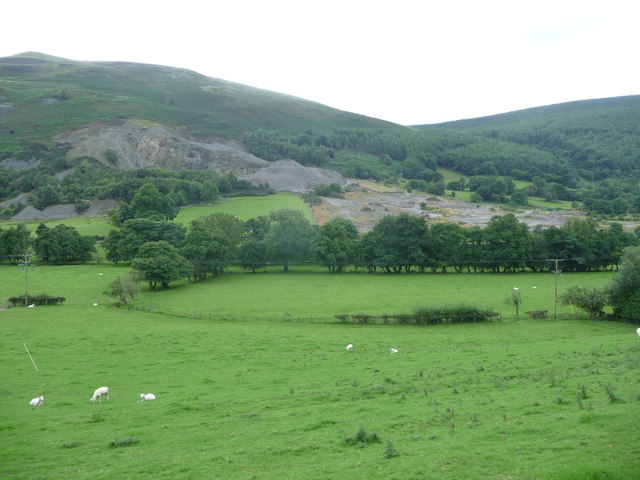
Large spoil heaps and a quarry scar remain on the hillside; roadstone quarrying from about 1913 removed or obscured some mining features.
Spoil heaps and workings on the hillside south of the village.
Redevelopment
Part of the site was later quarried for roadstone.
Related mines
- Craig-y-Mwyn Mine — Neighbouring Tanat valley lead mines worked by the Powis estate.
Nearby mines
- Craig-y-Mwyn Mine — 2.1 miles (3.4 km) NE
- Cynwyd Forest Quarry — 9.2 miles (14.8 km) N, Denbighshire
Straight-line distance, within 9 miles (15 km). Show on the map.
Recorded claims
Individual factual claims, each attached to the source(s) that support it below. Where sources disagree, both are kept.
- Mining began around 1705 under the Powis estate; the second Marquess of Powis saw the mine's richest period, and ore went to his Pool Quay smelter until about 1755. 1,2
- Production at South Llangynog peaked in 1737, when Llangynog was briefly one of the largest lead producing operations in Europe. 2
- The Powis section made a total profit of £121,000 in 1724-44. 2
- The Myddeltons and the London Lead Company worked the Chirk section from 1729 and gave it up by early 1736, having lost some £8,500. 1
- In 1815 the adit cut into the old workings, draining them so quickly that the miners barely escaped. 1
- By 1880 the mine was dead. 1
- Operating from c.1705, most productive from the 1730s, disused by 1887; some features removed by roadstone quarrying from c.1913. 3
Sources
- (secondary) Llangynog Mine — Northern Mine Research Society
- (secondary) Tanat Valley: industry and mining — Clwyd-Powys Archaeological Trust
- (secondary) South Llangynog Lead Mine (NPRN 34014) — Coflein (RCAHMW)
Record created: 17 October 2026 · Last researched: 17 October 2026