 MineArchive
Lightshaw Colliery
| Location | Lightshaw, east of Muirkirk, upper Ayr valley, East Ayrshire — 55.5364, -4.0353 (approximate) |
|---|---|
| Commodities | Coal, Ironstone |
| Type | Coal |
| Worked | By 1846–1918 |
| Operators | Eglinton Iron Company (owner) — Listed first as owner (DMM l256) William Baird & Company (owner) — William Baird and Co.; William Baird and Co. Ltd in the NMRS deaths records 1901-1910 (DMM l256) |
A colliery of four pits on Lightshaw farm, east of Muirkirk in the upper Ayr valley, worked by the Eglinton Iron Company and William Baird and Co. on Baird's own mineral railway. Its Six, Nine, Three and Four Feet seams were abandoned in 1918.
Location
Approximate location. The large pin is this mine; the small round markers are the nearest mines on record. Click one for its page. View on full map
History
Lightshaw takes its name from a farm east of Muirkirk, at the head of the Ayr valley, and coal was worked there long before the numbered pits: plans of the Nine Feet seam at Lightshaw and neighbouring Airdsgreen were closed in 1846, 1853 and 1864, and of the Three Feet in 1875.
The colliery as later listed had four pits, No. 1 and No. 2 together and No. 3 and No. 4 a little to the east, all served by Baird's Railway, the mineral line that also ran to Maidenbank and Grasshill. Its owners were the Eglinton Iron Co. and William Baird and Co. It employed 192 in 1894, falling steadily to 148 in 1905, 129 in 1910 and 72 in 1915, and sold household, manufacturing and steam coal, with ironstone in 1896 and gas coal from 1905. In 1910 and 1915 it worked the Nine Feet and Six Feet seams.
Plans of the Three Feet and Four Feet and of the Nine Feet and Six Feet were closed in 1907 and 1909, and the last, for the Six, Three, Four and Nine Feet seams of Lightshaw Nos. 1 to 4 and Airdsgreen, in 1918. The ground was later worked opencast at Ponesk.
Geology
Seams of the Muirkirk coalfield: the Nine Feet, Six Feet, Three Feet and Four Feet, with ironstone raised in 1896. Later opencast plans of Lightshaw Farm list the Cokeyard, Ell, Three Foot, Four Foot, Nine Foot, Thirty Inch, Six Foot and McDonald seams.
Workings
Four shaft pits, No. 1 and No. 2 together and No. 3 and No. 4 to the east, each with a mineral railway siding on Baird's Railway. The deaths recorded show stoop working, with falls of coal and roof as the commonest danger; in 1910 a pithead worker fell 462 feet down one shaft onto the other cage.
Closure
The workings were abandoned in stages from 1907, and the last plans of Lightshaw Nos. 1 to 4 are dated 1918.
What remains
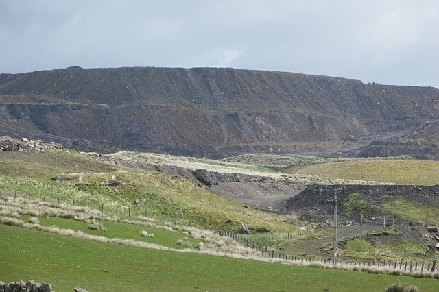
The site was later worked as an opencast and was derelict, unrestored, in 2015.
None identified; the ground has been opencasted.
Redevelopment
Opencast coal working at Ponesk, on the site of the Lightshaw and Maidenbank pits.
Related mines
- Grasshill Colliery — Both William Baird and Co. collieries above Muirkirk, served by the same mineral line, Baird's Railway, which ran to Maidenbank, Lightshaw and Grasshill.
Nearby mines
- Auldhouseburn Colliery — 1.3 miles (2.1 km) SW
- Glenbuck Colliery — 1.5 miles (2.4 km) E
- Muirkirk Collieries — 1.8 miles (2.8 km) SW
- Grasshill Colliery — 1.9 miles (3.0 km) E
- Kames Colliery — 2.4 miles (3.9 km) SW
Straight-line distance, within 9 miles (15 km). Show on the map.
Further reading
RailScot's entry for the No. 1 and No. 2 pits on Baird's Railway, with the neighbouring pits on the same line.
View sourceSources
- (primary) Lightshaw Colliery (Durham Mining Museum) — Durham Mining Museum
- (secondary) Lightshaw Colliery No 1 and 2 Pits (RailScot) — RailScot
- (secondary) Lightshaw Colliery Pit No 4 (RailScot) — RailScot
- (primary) BGS mine plan: LIGHTSHAW AND AIRDSGREEN, Nine Feet seam, abandoned 1846 — British Geological Survey
- (primary) BGS mine plan: LIGHTSHAW NO.1,2,3&4; AIRDSGREEN, Six Feet seam, abandoned 1918 — British Geological Survey
- (primary) BGS mine plan: LIGHTSHAW, Six Feet and Nine Feet seams, abandoned 1909 — British Geological Survey
- (observational) Open cast workings, Ponesk (Geograph 4515444) — Geograph (Richard Webb)
Record created: 5 November 2026 · Last researched: 5 November 2026