 MineArchive
Lawhead No. 1 Mine
| Location | Lawhead, Tarbrax, Carnwath parish, South Lanarkshire, close to the West Lothian border, South Lanarkshire — 55.7828, -3.5449 (approximate) |
|---|---|
| Commodity | Oil Shale |
| Type | Mineral |
| Worked | c. 1905–1906 |
| Operators | Tarbrax Oil Company Ltd (1905–1906, owner) — Worked the mine to serve Tarbrax oil works (Scottish Shale) |
A short-lived Fells Shale mine of the Tarbrax Oil Company on the moor at Tarbrax, opened about 1905 and abandoned by 1906-07, whose adit dived under the village at about 1 in 5 and whose brick foundations and tramway route survive on the moorland.
Location
Approximate location. The large pin is this mine; the small round markers are the nearest mines on record. Click one for its page. View on full map
History
Lawhead No. 1 mine was opened on the Lawhead estate in about 1905 by the Tarbrax Oil Company Ltd to supply its Tarbrax oil works. It worked the Fells Shale from a single adit that plunged westward beneath the village of Tarbrax at a gradient of about 1 in 5; apart from a couple of air shafts, everything came out through the adit. Shale went to the Tarbrax retorts by a tramway, carried into the works on staging; the 1910 Ordnance Survey map shows it as disused.
The mine lasted only about two years, and its Fells Shale workings were abandoned in 1906. Shale mining around Tarbrax was largely speculative and unsuccessful, and this mine was no exception. An earlier working, Lawhead No. 3 or Tarbrax No. 1, had been worked in the Fells Shale by the Caledonian Mineral Oil Company until it was abandoned in 1897.
Geology
The Fells Shale of the Cobbinshaw district.
Workings
A single adit at about 1 in 5 with a couple of air shafts, and a tramway, crossing the Maidwin Burn, to the Tarbrax retorts.
Closure
Abandoned in 1906, after about two years' work.
What remains
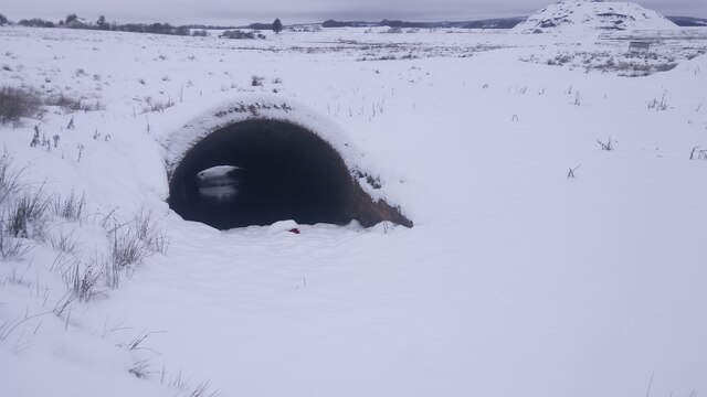
A collapsed adit mouth, substantial brick foundations and earthworks survive on the moorland; in 2021 the adit entrance was visible as a brick arch.
The adit mouth, brick foundations, earthworks and the line of the tramway to Tarbrax, including its crossing of the Maidwin Burn.
Redevelopment
None; open moorland.
Related mines
- Tarbrax Oil Shale Mine — Shared operator: both were Tarbrax Oil Company workings supplying its Tarbrax oil works (Scottish Shale).
- Viewfield No. 4 and 5 Pits — Both were worked by the Tarbrax Oil Company in the Cobbinshaw shale-field to supply Tarbrax Oil Works.
Nearby mines
- Tarbrax No. 1 and 2 Pits — 0.3 miles (0.5 km) NW
- Tarbrax Oil Shale Mine — 0.4 miles (0.7 km) W
- Greenfield No. 3 Mine — 0.7 miles (1.2 km) W
- Cobbinshaw No. 1 and 2 Pits — 0.8 miles (1.3 km) N, West Lothian
- Cobbinshaw South No. 3 Mine — 1.1 miles (1.7 km) NW, West Lothian
Straight-line distance, within 9 miles (15 km). Show on the map.
Further reading
The Museum of the Scottish Shale Oil Industry's page on the mine, with maps, LIDAR views and photographs of the adit and the tramway to Tarbrax.
View sourceSources
- (secondary) Lawhead No.1 mine (Scottish Shale, Museum of the Scottish Shale Oil Industry) — Museum of the Scottish Shale Oil Industry
- (observational) Lawhead Shale Mine Adit Entrance (Geograph 6739779, Ian Dodds) — Geograph
- (primary) BGS mine plan: LAWHEAD NO 1, TARBRAX, Fells, abandoned 1906 — British Geological Survey
Record created: 5 November 2026 · Last researched: 6 November 2026