 MineArchive
Lassodie Colliery
| Also known as | Lassodie Pits, Old Rows, New Rows and Fairfield |
|---|---|
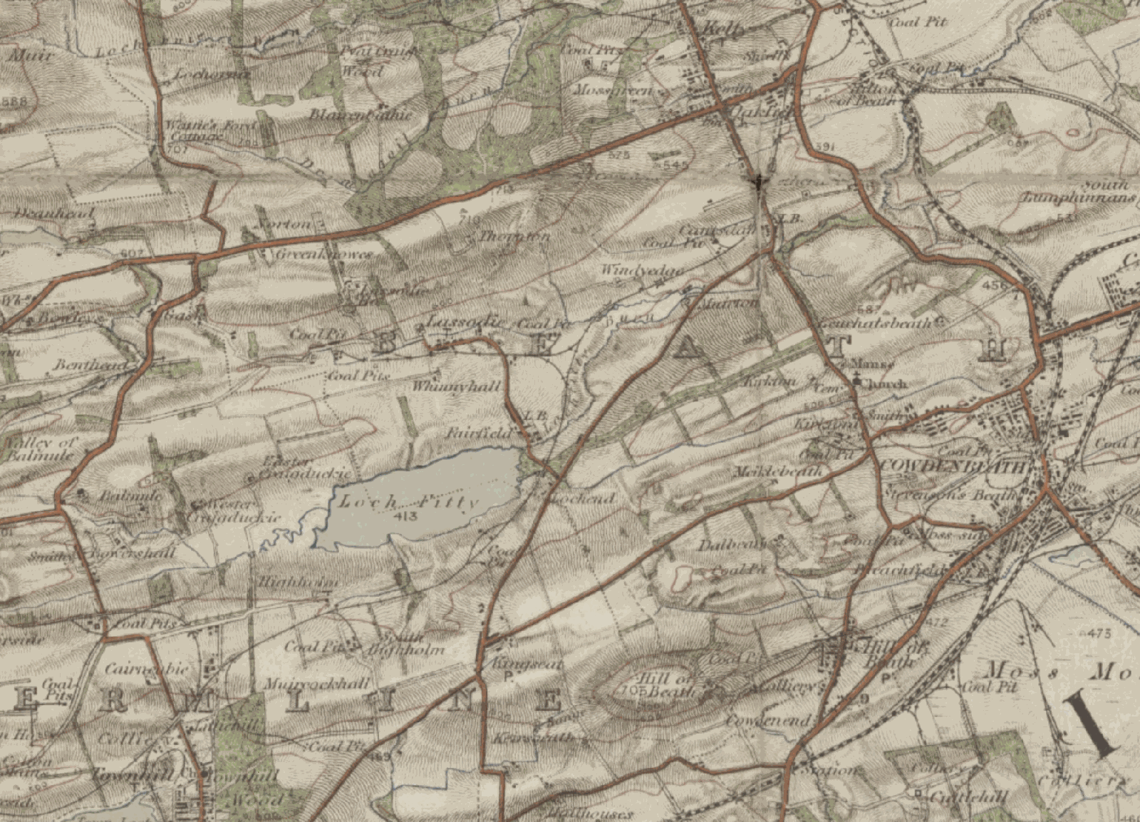
| Location | Between Kingseat and Kelty, about four miles north-east of Dunfermline, Fife — 56.1192, -3.4089 (exact) |
| Commodity | Coal |
| Type | Coal |
| Worked | 1859–May 1931 |
| Maximum depth | 124 fathoms (about 227 m) at No. 11 pit, sunk in 1893; No. 10 reached 60 fathoms (about 110 m). |
| Operators | Lassodie Coal Company (1859–1860), Thomas Spowart & Company Ltd. (1860–1931) |
Overview
The pits that made and then unmade a West Fife village. Coal was worked at Lassodie from 1859, and around them grew three linked hamlets — Old Rows, New Rows and Fairfield — holding some 1,400 people at their height, with eleven pits, a 250-pupil school, two co-operatives, brass and pipe bands and a football team. Water made the coal too expensive to win, the owners closed the pits in 1931, and the villagers were given fourteen days to leave their homes. Almost nothing is left.
History
The right to work coal on the Lassodie estate was leased from 1825 at the latest, and pit mining is recorded in the area from 1856. In 1859 the Lassodie Coal Company, under its general manager Mr Brownlie, began working at the western end of the estate, and houses were built for the miners near the pit head — the rows that became known as Old Rows. Thomas Spowart & Company took a lease over the estate's minerals in 1860.
As each seam was exhausted the company sank further pits, moving gradually eastwards, until in 1893 Nos. 10 and 11 were sunk at the east side of the estate, to 60 and 124 fathoms. The work was labour-intensive and drew miners and families in numbers: a second hamlet, New Rows, was built east of the first, and a third, Fairfield, south of that, the three connected by road and known collectively as Lassodie.
Beath School Board built a new school for the village in 1877 at a cost of £2,000, replacing an earlier colliery school; it eventually held nearly 250 pupils under eight teachers. The village had a Free Church, shops, a post office, two branches of the Co-operative Society, the Lassodie Tavern, a corrugated-iron hall, a working farm at its centre, a mines rescue team and a competition-winning ambulance team. Annie Reid served for years as the village's midwife, pit nurse, district nurse and occasional dentist, paid by a penny a week deducted from each miner's wages — the brass and pipe bands were maintained the same way. By 1901 the population had reached about 1,425. Before the First World War four pits were working at high pressure, raising some 1,300 tons a day.
The unravelling began with the 1921 strike, when two pits closed; families started to drift away after work elsewhere. The 1926 stoppage turned that drift into a haemorrhage. In May 1931 Thomas Spowart & Co. found the cost of winning the coal prohibitive — the workings needed constant pumping against heavy water — and closed the pits, giving the miners and their families fourteen days to quit the company houses.
Geology
The Lassodie estate lay in the parish of Beath in the West Fife coalfield, its coals worked seam by seam from the western end of the estate eastwards as each was exhausted. Nineteenth-century accounts of the ground also note blackband ironstone associated with a thin 'wild' coal that could be worked at moderate expense, and limestone on the lands. Water in the workings was the constant: it was the cost of keeping the pits clear of heavy volumes of it that finally made the coal too expensive to win.
Geological setting: Sedimentary Beds and Seams (well documented example)
Workings
Eleven pits in all across the estate, sunk successively from west to east as the seams were worked out. The last two, Nos. 10 and 11 of 1893, were sunk at the eastern side to 60 fathoms and 124 fathoms respectively. The village had its own mines rescue team and an ambulance team that won competitions. Pumping was heavy and continuous, and in the end decisive.
Closure
Two pits closed at the 1921 strike and the population began to fall; the 1926 stoppage accelerated it. In May 1931 Thomas Spowart & Co. closed the remaining pits, the cost of keeping the workings clear of heavy water having become prohibitive, and gave the miners and their families fourteen days to vacate the company houses. Opencast working returned to the ground in the 1960s and again from the late 1990s to 2013.
What remains
Almost nothing of the village or the pits remains. The church and manse, disused by about 1930, were reopened in 1932 by the Rev. David Patrick Thomson as the St Ninian's retreat and conference centre — the Olympic athlete Eric Liddell was among its visitors — and served briefly around the start of the Second World War as a hostel for refugees from occupied Europe before being closed and demolished. Later opencast working, latterly as the St Ninian's Opencast Mine, reworked the ground until 2013, with landscaping begun towards a sculpture park to a design by Charles Jencks; that work has since stopped. The village war memorial still stands alone beside the B912 Kingseat to Kelty road, recording twenty-one men lost in the First World War and four in the Second.
The war memorial beside the B912, standing in isolation; the ground itself has been reworked by opencast mining and partly landscaped.
Redevelopment
Opencast coal was worked over the site in the 1960s and again from the late 1990s until 2013 as the St Ninian's Opencast Mine. Landscaping towards a sculpture park designed by Charles Jencks was begun but has stopped.
Related mines
- Elgin and Wellwood Colliery — Thomas Spowart and Company worked both, and William Wilkinson moved from managing Lassodie to Elgin and Wellwood in 1908.
Nearby mines
- Kingseat Colliery — 1.2 miles (1.9 km) S
- Blairenbathie Colliery — 1.4 miles (2.3 km) N, Perth and Kinross
- Muirbeath Colliery — 1.5 miles (2.4 km) S
- Blairadam Colliery — 1.5 miles (2.5 km) NE
- Dalbeath Colliery — 1.7 miles (2.8 km) SE
Straight-line distance, within 9 miles (15 km). Show on the map.
Disasters & major incidents
-
Lassodie Colliery shaft accident, 1866
29 May 1866 · Winding / Shaft Accident · 2 fatalities
Two young colliers at Lassodie Colliery, near Dunfermline, were killed on 29 May 1866 when stones fell from the side of the shaft.
Recorded claims
Individual factual claims, each attached to the source(s) that support it below. Where sources disagree, both are kept.
- The right to work coal was leased from 1825 at the latest and pit mining is recorded in the area from 1856; the Lassodie Coal Company began working the western end of the estate in 1859, and Thomas Spowart & Company took a lease over the estate's minerals in 1860. 1,2
- The village was a collective name for three settlements — Old Rows, New Rows (or Parley) and Fairfield — built successively as the workforce grew and connected by road. 1,2
- In 1893 pits Nos. 10 and 11 were sunk at the east side of the estate, to 60 fathoms and 124 fathoms respectively. 1
- By 1901 Lassodie was a community of eleven pits, some 200 houses and a population of about 1,425, with a school of nearly 250 pupils under eight teachers, a railway station, post office, church and football team. 1,2
- Before the First World War four pits were working at high pressure, producing some 1,300 tons of coal a day. 1
- Annie Reid served the village for years as midwife, pit nurse, district nurse and occasional dentist, her wages found by a penny a week deducted from each miner's pay; the brass and pipe bands were maintained the same way. 1
- In May 1931 Thomas Spowart & Co. closed the remaining pits, the cost of keeping the workings clear of heavy water having become prohibitive, and gave the miners and their families fourteen days to vacate the company houses. 1,2
- The disused church and manse were reopened in 1932 by the Rev. David Patrick Thomson as the St Ninian's retreat and conference centre, visited among others by the athlete Eric Liddell, and were used briefly as a hostel for refugees from occupied Europe before being closed and demolished. 1
Photographs & further reading
Transcribed newspaper and estate material on Lassodie, including nineteenth-century descriptions of the estate's coal, blackband ironstone and lime.
View sourceGeorge Robertson's account of the village — the three hamlets, the school, the co-operatives, the penny-a-week nurse and bands, and the fourteen days the families were given to leave in 1931.
View sourceSources
- (secondary) George Robertson, 'Lassodie, the Lost Village' — Dunfermline Historical Society
- (secondary) Lassodie — Wikipedia
- (secondary) Lassodie History — Scottish Mining Website
Record created: 3 September 2026 · Last researched: 3 September 2026