 MineArchive
Intake Dale Mine
| Location | Intake Dale, Hazlebadge, south-west of Bradwell, Derbyshire — 53.3138, -1.7558 (exact) |
|---|---|
| Commodity | Lead |
| Type | Metal |
| Maximum depth | About 70 m (engine shaft); 85 m in the cave register |
A lead mine on Shuttle Rake in Intake Dale, Hazlebadge, with a rock-cut gin circle and a 70-metre engine shaft, whose stacked workings break into natural cave.
Location
Recorded location. The large pin is this mine; the small round markers are the nearest mines on record. Click one for its page. View on full map
History
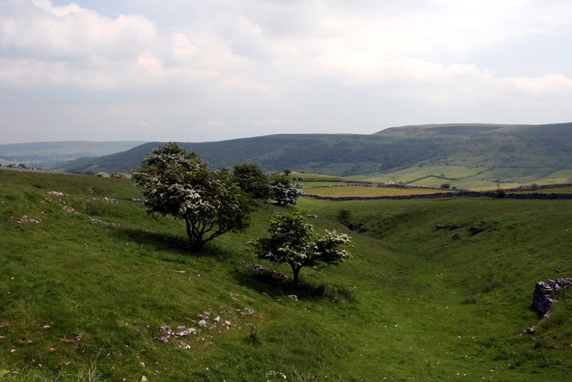
Intake Dale Mine lies in Intake Dale, in Hazlebadge liberty south-west of Bradwell, on the south flank of the dale where Shuttle Rake crosses it. Shuttle Rake was worked for lead along about a mile and a half, and this western end is the last part of the rake left unrestored after the opencast working further east. When the mine was worked, and by whom, is not known. At the surface there is a fine rock-cut gin circle and some unusual retained hillocks. A hauling shaft in the dale floor, now backfilled, has a terraced gin-circle platform above it, and the engine shaft, about 70 metres deep, was long blocked at the top and concealed.
Underground, the old miners stacked their waste rock in great packs, held up on timber stemples, uprights and cross-poles through the vein stopes, and they sorted and stacked it in the natural passages too. The workings break into natural cave: joint passages and a large cubic chamber about 6 metres high and 8 metres wide and long, its flat roof crossed by the faulted vein. A muddy tide-mark about 2 metres up its walls shows where it has flooded. Cavers wrote about the mine in 1994 and took up its exploration again in 2016. Around 2020 the Eldon Pothole Club reopened the engine shaft, and the Derbyshire Caving Association rebuilt it within a plinth of stacked deads under a steel lid.
Geology
Shuttle Rake, an east-west lead vein in the limestone, crossing Intake Dale; the vein is faulted, and the workings intersect natural joint passages and a large natural chamber. The mine worked lead ore.
Workings
An engine shaft about 70 metres deep, a backfilled hauling shaft in the dale floor below a gin-circle platform, and a narrow vein stope about 30 metres deep, with timbered and stemple-supported packs of stacked waste. The cave register records 91 metres of passage and a depth of 85 metres.
What remains
The hillocks are mostly disturbed or removed, but part of a gin circle survives, rock-cut, with unusual retained hillocks. The engine shaft has been reopened and rebuilt with a steel lid. Most of the underground workings are very loose.
A rock-cut gin circle, a terraced gin-circle platform over the backfilled hauling shaft, retained hillocks, and the rebuilt engine shaft top within a plinth of stacked deads.
Redevelopment
Shuttle Rake east of Intake Dale was opencast and restored.
Related mines
- Shuttle Rake Mine — Works the same vein: Shuttle Rake, Intake Dale Mine on its Hazlebadge length east of the Shuttle Rake Engine.
Nearby mines
- Chance Mine — 0.3 miles (0.5 km) NW
- Pic Tor End Mine — 0.5 miles (0.8 km) NE
- Shuttle Rake Mine — 0.6 miles (0.9 km) W
- Bank Top Mine — 0.6 miles (1.0 km) N
- Hartle Dale Bottom Mine — 0.6 miles (1.0 km) NW
Straight-line distance, within 9 miles (15 km). Show on the map.
Further reading
The county record of Intake Dale Mine and Shuttle Rake, with the mine's rock-cut gin circle and retained hillocks.
View sourceThe caving register's entry for the mine, with its position, its 70-metre engine shaft and the reopening of that shaft.
View sourceA 2016 caving club account of the mine's stacked workings, its backfilled hauling shaft and its natural chamber.
View sourceSources
- (secondary) MDR8796 - Intake Dale Mine and Shuttle Rake, Tideswell, Bradwell and Hazlebadge — Derbyshire Historic Environment Record
- (observational) Intake Dale Mine (Peak District Caving) — Peak District Caving
- (observational) Intake Dale Mine (Technical Speleological Group trip report, 2016) — Technical Speleological Group
- (observational) Intake Dale Mine, additional information (Peak District Caving) — Peak District Caving
Record created: 18 November 2026 · Last researched: 19 November 2026