 MineArchive
Hollandtwine Mine
| Also known as | Doctor Hollands Engine Shaft, Holland Twine, Hollands Twine |
|---|---|
| Location | Dirtlow Rake, Castleton, Derbyshire — 53.3281, -1.7915 (approximate) |
| Commodity | Lead |
| Type | Metal |
| Worked | from Post-medieval |
| Maximum depth | The mine reached about 130 m, with the winding shaft open to about 115 m; the Great Swallow pothole in the vein reached about 185 m, and is given elsewhere as 610 ft. |
Overview
A large post-medieval lead mine on Dirtlow Rake above Castleton, worked to about 130 metres and cutting a natural pothole in the vein called the Great Swallow. Its shaft top was quarried away for fluorspar in the early 1990s and the mine is now lost.
History
Hollandtwine was one of the major lead mines on Dirtlow Rake, the great east-west vein above Castleton, and shared its ground with Hazard Mine immediately to the west. The Derbyshire Historic Environment Record classes it as a post-medieval lead mine with a coe, a winding circle, a mine shaft, a crushing circle and a drainage level. A survey of Hazard Mine dated 17 June 1837 draws the boundary between the two mines and marks, on the Hollandtwine side, 'The Great Swallow in the Twine' — a natural cavern in the vein of such size, if the survey's scale is anywhere near right, that it drew cavers to the mine a century and a half later. The two mines were connected at times, and both are thought to have drained through the Great Swallow in the late eighteenth or early nineteenth century, the water probably going into Peak Cavern.
The mine was still largely intact when, one Saturday morning in the mid-1960s, members of the Eldon Pothole Club of Buxton brought photocopies of old mining records from the Bagshaw Collection in Sheffield City Library to the Pegasus Club's hut at Peak Forest. The plans showed the Great Swallow, the Eldon men had found the entrance shaft open and in good condition and estimated its depth at more than 250 feet, and they lacked the ladder to descend it. Pegasus had ladder, and Hollandtwine became a club project that ran for decades. Before the mine was destroyed there survived a coe, a gin circle with its winding shaft beside it, open to about 115 metres, and a crushing circle with its wheel, all near the middle of a large wasteheap. Modern opencast working for fluorite and barytes along the line of Dirtlow Rake then took the site: the shaft top was quarried away during work on the Dirtlow Pit fluorite deposit in the early 1990s, repeated later attempts to uncover it failed, and access was permanently lost. A 1990s proposal to consolidate the Hollandtwine and Hazard workings with the Laporte Minerals opencast was never carried through.
Geology
The mine worked Dirtlow Rake, one of the important lead veins of the South Pennine orefield, where the rake is a near-vertical fissure in the Carboniferous limestone running east from Castleton. The vein carried a natural pothole, the Great Swallow, which the mine intersected and which reached far deeper than the workings. Later reworking along the rake has been for fluorspar, barytes and calcite rather than lead.
Geological setting: Veins and Lodes (well documented example)
Workings
A shaft mine on the rake. A gin circle stood with its winding shaft beside it, the shaft open to about 115 metres, and a coe and a crushing circle with its wheel stood near the centre of a large wasteheap. The workings went down about 130 metres and cut the Great Swallow, a natural pothole in the vein reaching about 185 metres, which is thought to have drained both this mine and Hazard Mine to the west in the late eighteenth or early nineteenth century. A drainage level is recorded among the mine's components. The entrance shaft, which the Eldon Pothole Club found open in the mid-1960s and put at over 250 feet, stood near the Dirtlow to Eldon Hill track on the north east side of Hazard Mine.
Closure
No date is recorded for the end of lead working. The Historic Environment Record places the mine's components in the post-medieval period, 1540 to 1900, and the shaft was still open and in good condition when cavers found it in the mid-1960s. The mine's physical end came with modern mineral working: the shaft top was quarried away in the early 1990s.
What remains
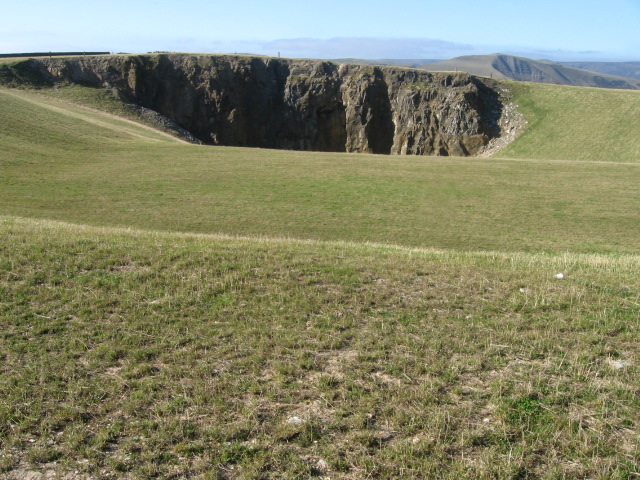
Lost. The large mine complex on Dirtlow Rake has been destroyed by reworking along the vein, and open quarrying for fluorite and barytes now operates on the site. The entrance shaft was near the Dirtlow to Eldon Hill track beside Hazard Mine, but its top was quarried away during work on the Dirtlow Pit fluorite deposit in the early 1990s; despite repeated later attempts to uncover it, access was permanently lost.
None. The coe, the gin circle, the adjacent winding shaft, the crushing circle and its wheel, and the wasteheap they stood on have all been removed by opencast working along the rake.
Redevelopment
The site is under a working fluorspar and barytes opencast on the line of Dirtlow Rake, immediately alongside the former Laporte Minerals pit.
Related mines
- Hazard Mine — Adjoining mines on Dirtlow Rake, connected at times underground and both thought to have drained through the Great Swallow in Hollandtwine. The 1837 Hazard Mine survey draws the boundary between the two, and both were removed by the same opencast working.
Nearby mines
- Hazard Mine — 0.3 km W
- New Rake Lead Mines — 0.8 km N
- Slitherstone and Linacre Lead Mines — 1.3 km W
- Oxlow Rake Lead Mines — 1.4 km SW
- Pin Dale Lead Side Veins — 2.1 km NE
Straight-line distance, within 15 km. Show on the map.
Recorded claims
Individual factual claims, each attached to the source(s) that support it below. Where sources disagree, both are kept.
- The Derbyshire Historic Environment Record classes Hollandtwine as a post-medieval lead mine with a coe, a winding circle, a mine shaft, a crushing circle and a drainage level, centred at SK 1405 8118 in the parish of Castleton. 1
- Before its destruction there was a coe, a gin circle with an adjacent winding shaft open to about 115 m, and a crushing circle with its wheel, all near the centre of a large wasteheap. 1
- The mine reached a depth of about 130 m and intersected a natural pothole in the vein known as the Great Swallow, which reached about 185 m. 1
- Hollandtwine was connected at times to Hazard Mine to the west, and both are thought to have been drained through the Great Swallow in the late eighteenth or early nineteenth century, probably into Peak Cavern. 1
- A survey of Hazard Mine dated 17 June 1837, from the Bagshaw Collection in Sheffield City Library, shows the boundary between Hazard and Hollandtwine and carries the inverted note 'The Great Swallow in the Twine'. 2
- Members of the Eldon Pothole Club of Buxton located the entrance shaft in the mid-1960s, found it open and in good condition and estimated its depth in excess of 250 feet; having no ladder long enough, they brought the mine's plans to the Pegasus Club, which did, and Hollandtwine became a Pegasus project for many years. 2
- The entrance shaft stood near the Dirtlow to Eldon Hill track on the north east side of Hazard Mine, but its top was quarried away during workings on the Dirtlow Pit fluorite deposit in the early 1990s, and despite repeated later attempts to uncover it access was permanently lost. 1,3
- The mine complex on Dirtlow Rake has been destroyed by reworking along the vein, and modern open quarrying for fluorite and barytes now operates on its site. 1
- The mine is also recorded as Doctor Hollands Engine Shaft, and mineral specimens have been labelled as from the Holland Twine pit. 2
Photographs & further reading
The county record's monument entry, describing the mine's components and depths and citing Ford and Rieuwerts, Rieuwerts on the soughs, and Barnatt's 1992 survey of land at Aston Hall.
View sourceA long compiled account of the club's decades of work at the mine, including the 1837 Hazard Mine survey and its key, and how the Eldon Pothole Club first found the shaft.
View sourceThe site record, giving its grid reference and altitude, its published references from 1966 onwards, and the loss of the entrance to quarrying in the early 1990s.
View sourceSources
- (primary) MDR2300 — Hollandtwine Mine (site of), Dirtlow Rake, Castleton — Derbyshire Historic Environment Record
- (observational) Hollandtwine Mine: a record of exploration by the Pegasus Club, Nottingham — Pegasus Caving Club, compiled by S. Chester
- (observational) Hollandtwine Mine, Castleton area — Peak District Caving
Record created: 23 September 2026 · Last researched: 28 September 2026