 MineArchive
Gurnard's Head Mine
| Also known as | Wheal Treen, Treen Copper Mine, North United and Gurnard's Head Mine |
|---|---|
| Location | Treen Cove, east of Gurnard's Head, Zennor parish, Penwith, Cornwall — 50.1886, -5.5941 (approximate) |
| Commodity | Copper |
| Type | Metal |
| Worked | Before 1821–1877 |
| Maximum depth | 90 fathoms (North shaft) |
Overview
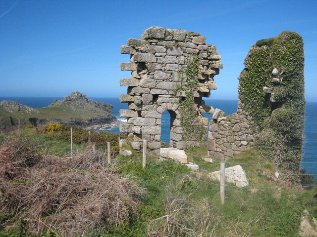
A small copper mine on the cliffs above Treen Cove, east of Gurnard's Head in Zennor parish, at work by 1821 as Treen Copper Mine. Its workings are thought to run under the sea. The ruined house of a 30-inch pumping engine of 1844 stands beside the coast path; the mine fell out of use in 1877.
History
The mine lies on the cliffs overlooking Treen Cove, just east of the headland of Gurnard's Head on the north coast of Penwith. Work was under way by 1821 under the name Treen Copper Mine, or Wheal Treen, and its first shaft was so close to high water that it needed a stone collar to keep the sea out. It worked two intersecting lodes in metamorphosed killas; there are no plans, but the workings are thought to run beneath the sea.
Engine shaft reached 47 fathoms in very poor ground, and North and South shafts were taken to 90 and 80 fathoms. The mine was called Gurnard's Head from 1834 until 1843, and from 1844 it was worked as North United and Gurnard's (or Gurnett's) Head mine. In 1844 a 30-inch Harvey's pumping engine was put up on South shaft; it was sold in 1848 to the Guadalcanal mine in Spain.
Output was small: 24 tons of copper ore recorded for 1834 and 1842, and 25 tons of 12 per cent ore in 1853. The mine fell into disuse in 1877.
Geology
Two intersecting copper lodes in metamorphosed killas, worked out under the sea.
Workings
Engine shaft (47 fathoms), North shaft (90 fathoms) and South shaft (80 fathoms), the last pumped from 1844 by a 30-inch Harvey's engine with a single boiler and a separate stack.
Closure
The engine was sold to Spain in 1848; the mine worked on in a small way and fell into disuse in 1877.
What remains
The ruined engine house stands on the cliff beside the South West Coast Path, its walls in poor condition and the area fenced off.
The South shaft engine house, the base of its detached stack, remains of another building to the south, and shafts.
Redevelopment
Unknown.
Nearby mines
- Carn Galver Mine — 1.5 miles (2.4 km) SW
- Rosevale Mine — 2.2 miles (3.6 km) E
- Ding Dong Mine — 2.5 miles (4.1 km) S
- East Boscaswell Mine — 3.6 miles (5.8 km) SW
- Pendeen Consols — 3.8 miles (6.1 km) SW
Straight-line distance, within 9 miles (15 km). Show on the map.
Recorded claims
Individual factual claims, each attached to the source(s) that support it below. Where sources disagree, both are kept.
- The mine was at work before 1821 as Treen Copper Mine. 1,2,3
- It was called Gurnard's Head from 1834 to 1843 and North United and Gurnard's Head from 1844. 1
- A 30-inch Harvey's pumping engine was built on South shaft in 1844 and sold in 1848 to the Guadalcanal mine in Spain. 1
- It worked two intersecting lodes in metamorphosed killas, thought to run under the sea; no plans survive. 4,3
- In 1853 it produced 25 tons of 12 per cent copper ore. 4,1,3
- The mine fell into disuse in 1877. 3
Photographs & further reading
A historic photograph of the old mine works in the Penlee House collection.
View sourceThe mine's names, shafts, engine and recorded output.
View sourceSources
- (secondary) Explore Cornwall: Gurnard's Head Mine — Explore Cornwall
- (secondary) Wikipedia: Gurnard's Head — Wikipedia
- (secondary) Penlee House Gallery and Museum: photograph PEZPH 2016.50.589, Gurnard's Head Mine — Penlee House Gallery and Museum
- (secondary) NMRS: Gurnards Head Mine — Northern Mine Research Society
Record created: 11 October 2026 · Last researched: 11 October 2026