 MineArchive
Fortissat Colliery
| Location | Fortissat, near Salsburgh and Shotts, North Lanarkshire — 55.8381, -3.8440 (exact) |
|---|---|
| Commodity | Coal |
| Type | Coal |
| Worked | By 1875–1949 |
| Maximum depth | Unknown. |
| Operators | Baton Collieries Ltd (?–1947), National Coal Board (1947–1949), James Scobbie and Co., Shotts Iron Company |
Overview
A coal and ironstone working on the lands of Fortissat, north-west of Shotts in Lanarkshire, recorded from the 1870s and owned by James Scobbie and Co., Baton Collieries and the Shotts Iron Company. It worked the Drumgray seams and Shotts Gas Coal, employed over 260 at nationalisation and was abandoned in 1949.
History
Fortissat lies north-west of Shotts, towards Salsburgh, in the parish of Shotts. A plan of workings on the lands of Fortissat dates from 1875, another shows the Shotts Iron Company's workings of the Slaty Band ironstone, and the national record classes the site as both a nineteenth-century colliery and an ironstone mine. A plan of the Mill seam was abandoned in 1887.
The Lists of Mines record the colliery under James Scobbie and Co. and later Baton Collieries Ltd, and its spoil heap is still called Scobie's Bing. It employed 55 people in 1894, 110 in 1905 and 180 by 1920, working the Lower and Upper Drumgray seams, then the Mid Drumgray and the Shotts Gas Coal, for household, manufacturing and steam coal. A mineral railway, the Fortissat branch, served it. In March 1936, when The Scotsman described Fortissat as belonging to the Shotts Iron Company, the colliery stood idle for a day after a machineman, Peter M'Leod, was killed when his coal-cutting machine kicked.
The National Coal Board took Fortissat over in 1947, when it raised 50,000 tons with 262 people, including coking and gas coal. The last plan of its Mid Drumgray workings was abandoned in 1949. Ground nearby was worked much later as the Easter Fortissat opencast site, abandoned in 1998.
Geology
Lanarkshire coalfield: the Lower (Smithy), Mid and Upper Drumgray seams, the Shotts Gas Coal, Main, Mill and Furnace seams, and the Slaty Band ironstone.
Workings
Coal and ironstone workings on the lands of Fortissat from the 1870s; the Fortissat branch mineral railway; Scobie's Bing.
Closure
The last abandonment plan, of the Mid Drumgray seam, is dated 1949, two years after nationalisation.
What remains
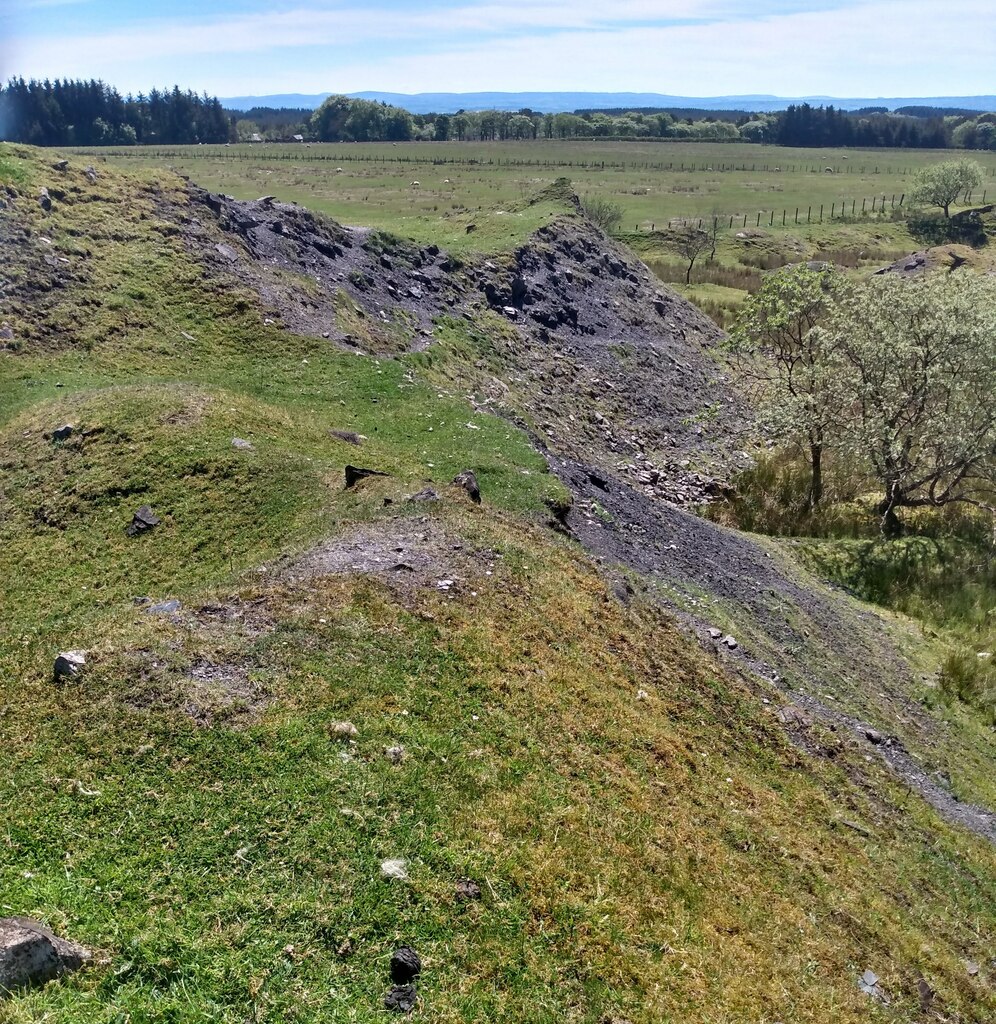
The remains of Scobie's Bing survive among grazing land, and the route of the colliery railway can still be traced.
Remains of the spoil heap (Scobie's Bing) and the trackbed of the mineral railway.
Redevelopment
Unknown.
Nearby mines
- Hillhouserigg Colliery — 1.5 miles (2.4 km) SE
- Hassockrigg Colliery — 1.7 miles (2.8 km) E
- Calderhead Colliery — 2.0 miles (3.2 km) E
- Shotts Iron Works — 2.2 miles (3.6 km) SE
- Ardenrigg Colliery — 2.5 miles (4.1 km) NW
Straight-line distance, within 9 miles (15 km). Show on the map.
What's uncertain
Points where sources disagree or the record could not be settled; both accounts are kept. All open questions in the archive.
- In March 1936 Fortissat Colliery was described as belonging to the Shotts Iron Co. (Ltd.). (disputed) 3
Recorded claims
Individual factual claims, each attached to the source(s) that support it below. Where sources disagree, both are kept.
- Fortissat is recorded as a nineteenth-century colliery and ironstone mine. 1
- James Scobbie and Co. and later Baton Collieries Ltd owned the colliery before the National Coal Board. 2
- In March 1936 Fortissat Colliery was described as belonging to the Shotts Iron Co. (Ltd.). (disputed) 3
- The Shotts Iron Company worked the Slaty Band ironstone at Fortissat. 4
- The colliery employed 55 people in 1894, 180 in 1920 and 262 in 1947, when it raised 50,000 tons. 2
- It worked the Lower and Upper Drumgray seams, and from 1915 the Mid Drumgray and the Shotts Gas Coal. 2
- On a Sunday night in March 1936 a machineman, Peter M'Leod, was killed when his coal-cutting machine kicked, and the colliery stood idle the next day. 3
- The plan of the Mid Drumgray workings at Fortissat was abandoned in 1949. 5
- A plan of the Mill seam at Fortissat was abandoned in 1887. 6
Photographs & further reading
The route of the mineral railway that served the colliery.
View sourceThe national record of the colliery and ironstone mine, with its location and references.
View sourceOwners, employment, output and seams from the Lists of Mines.
View sourceSources
- (secondary) Fortissat Colliery (NRHE 82222) — Historic Environment Scotland (trove.scot, formerly Canmore)
- (primary) Fortissat Colliery — Durham Mining Museum
- (primary) Shotts parish accidents post 1900 — Scottish Mining Website — Scottish Mining Website
- (primary) BGS mine plan: Fortissat Slatyband ironstone workings by the Shotts Iron Co. — BGS / Mining Remediation Authority mine plans
- (primary) BGS mine plan: Fortissat, Mid Drumgray, abandoned 1949 — BGS / Mining Remediation Authority mine plans
- (primary) BGS mine plan: Fortissat, Mill, abandoned 1887 — BGS / Mining Remediation Authority mine plans
Record created: 4 October 2026 · Last researched: 4 October 2026