 MineArchive
Esgair Hir and Esgair Fraith Mines
| Also known as | Cambrian Mine, Cardigan Consolidated Mine, Welsh Potosi Mine, Kylon Potosi Mine |
|---|---|
| Location | North of Nant-y-Moch reservoir, six miles east of Talybont, Powys — 52.5069, -3.8700 (approximate) |
| Commodities | Lead, Copper |
| Type | Metal |
| Worked | 1691–1904 |
| Operators | Sir Carbery Pryse (1689–1704), William Waller (?–1694), Company of Mines Adventurers of England (1703–1708), Sir Humphrey Mackworth (1703–1708), Williamson & Eyton (1839–1848), Cardigan Consols (1858–1867), Cambrian Company (1877–1882) |
Overview
Esgair Hir and Esgair Fraith, two lead mines worked together on the same vein north of the Nant-y-Moch reservoir, were acclaimed in their day as 'the richest in all Wales' — the Welsh Potosi — and their 1689 legal battle with the Crown helped open up private mining across the country.
History
An ore outcrop at Esgair Hir was discovered before 1690, and the estate's owner, Sir Carbery Pryse, began working it himself -- directly challenging the Society of Mines Royal's royal monopoly over gold- and silver-rich mines. The courts ruled in Pryse's favour in 1689, letting him form a company and mine freely, a victory that opened up private capital and new mines across Wales more broadly. Pryse died in 1694; his former manager William Waller and Sir Humphrey Mackworth reformed the operation as the Company of Mines Adventurers of England, which worked the site from 1703 to 1708, raising around 2,000 tons of ore before stopping. After long fallow periods and lesser attempts in 1760 and 1788, Williamson & Eyton took on the mine in 1839, spending the winter of 1839-40 building four and a half miles of road to it and installing large pumping machinery; that phase lasted until 1848. The Welsh Potosi Company that followed built new surface structures and steam engines, but its miners struck over unpaid wages in 1856 and the company was declared bankrupt in 1857. Cardigan Consols worked the site from 1858 to 1867, concentrating on shaft development with little ore to show for it before giving up. In 1877 the Cambrian Company took over, using a steam engine to drain the workings until the old waterwheel and its long line of pump rods to Engine Shaft had been repaired; no worthwhile ore was found at Esgair Hir itself, so the company turned to the mine's eastern end at Esgair Fraith, developing ground between the Copper and Eastern Shafts. Some copper ore was won there, but at a time of rapidly falling copper prices, and the company went into liquidation in 1882 -- by which point an 1887 Ordnance Survey map was recording the two halves of the site separately, as the Cambrian Lead Works (Esgair Hir) and Cambrian Copper Works (Esgair Fraith). A series of small, undercapitalised partnerships stripped what remained of the old workings between 1886 and 1904, when the mine finally closed for good -- defeated, as so often, by its remote mountain location, chronic undercapitalisation, and falling ore prices.
Geology
Esgair Hir and Esgair Fraith lie on a mineralised fracture zone, up to 60ft wide in places, running east-west along the Ordovician-Silurian boundary and traced for some 4km; lead ore occurs in vertical pipes that narrow with depth, with copper content rising and lead falling toward Esgair Fraith to the east.
Workings
Worked with Esgair Fraith on the same vein; Cardigan Consols concentrated on shaft development between 1858 and 1867 with little ore to show for it.
Closure
The company went into liquidation in 1882 amid rapidly falling copper prices; small partnerships stripped what remained until the mine finally closed in 1904.
What remains
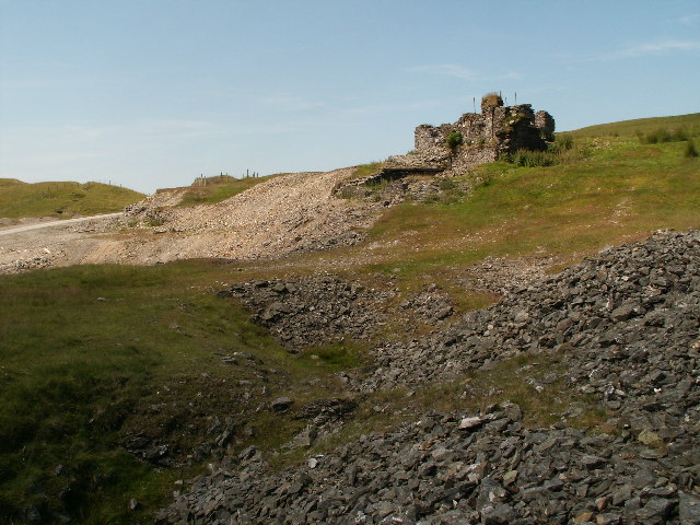
A substantial range of ruins survives, including barracks, the 1872 engine house and crushing mill, blocked Crown Pits shafts, a round powder house, and Shaft Glas with its finely engineered pump-rod tunnel running two-thirds of a mile to Esgair Fraith; the site has suffered damage from forestry operations and faces a proposed wind development. It is also a Site of Special Scientific Interest, valued for hosting the largest number of metallophyte lichens of any site in Ceredigion -- including the rare metallophyte liverwort Cephaloziella nicholsonii -- supported by the metal-rich soil the historic mining left behind.
A barracks range with buttressed walls and a large kitchen, the ruined 1872 engine house and crushing mill, blocked Crown Pits shafts lining the hillside, a round powder house, and Shaft Glas -- notable for its finely engineered stonework and an innovative pump-rod tunnel running two-thirds of a mile to Esgair Fraith.
Nearby mines
- Eaglebrook Mine — 1.5 miles (2.4 km) S, Ceredigion
- Rhyd Fach Mine — 1.8 miles (2.9 km) S, Ceredigion
- Ystrad Einion Mine — 2.1 miles (3.4 km) NW, Ceredigion
- Hafan Mine — 2.2 miles (3.6 km) S, Ceredigion
- Bwlch Glas Mine — 2.3 miles (3.8 km) SW, Ceredigion
Straight-line distance, within 9 miles (15 km). Show on the map.
Recorded claims
Individual factual claims, each attached to the source(s) that support it below. Where sources disagree, both are kept.
- Sir Carbery Pryse's decision to work the ore outcrop at Esgair Hir himself, discovered before 1690, directly challenged the Society of Mines Royal's monopoly over precious-metal mining; the courts ruled in his favour, a victory that helped open up private capital and new mines across Wales. 1
- The Company of Mines Adventurers of England worked Esgair Hir and Esgair Fraith from 1703 to 1708, raising around 2,000 tons of ore. 1
- Williamson & Eyton, who took on the mine in 1839, spent the winter of 1839-40 building four and a half miles of road to reach it, and installed large pumping machinery, working the site until 1848. 1
- The Welsh Potosi Company's miners struck over unpaid wages in 1856, and the company failed the following year. 1
- A series of small, undercapitalised partnerships stripped what remained of the old workings between 1886 and 1904, when the mine finally closed for good. 1
- Sir Carbery Pryse died in 1694; his former manager William Waller and Sir Humphrey Mackworth reformed the operation as the Company of Mines Adventurers of England, which worked the site from 1703 to 1708. 1
- In 1877 the Cambrian Company took over, draining the workings and later developing Esgair Fraith's copper ground when no worthwhile ore was found at Esgair Hir itself; falling copper prices brought the company into liquidation in 1882, by which point an 1887 OS map recorded the two halves of the site separately as the Cambrian Lead Works and Cambrian Copper Works. 1
- Esgair Hir's abandoned, unreclaimed mine workings, now a Site of Special Scientific Interest, host the largest number of metallophyte lichens of any site in Ceredigion, including the rare metallophyte liverwort Cephaloziella nicholsonii, both supported by the metal-rich soil the historic mining left behind. 2
- A substantial range of ruins survives at the site, including a barracks range, the 1872 engine house and crushing mill, blocked Crown Pits shafts, a round powder house, and Shaft Glas with its finely engineered pump-rod tunnel running two-thirds of a mile to Esgair Fraith; the mine offices and workshops are where the travel writer George Borrow reportedly once sheltered. 3
Photographs & further reading
A detailed modern exploration account of the mine's surviving ruins, including the barracks, engine house and Shaft Glas.
View sourceSources
- (secondary) Esgair Hir & Esgair Fraith Mines — Northern Mine Research Society
- (secondary) Esgair Hir — Woodland Trust
- (observational) Esgair Hir - chasing dreams of silver — Treasure Maps (exploration blog)
Record created: 20 August 2026 · Last researched: 31 August 2026